A long day on a combination of easy and difficult trails brought us through three towns and an abandoned village, and to an unexpectedly not-so-great campsite
We arranged with Don yesterday to take us back to the Tinkers Point Path trailhead at 8:30 am, and he was ready to go just as we were. 15 minutes later, we were back at the trailhead, and started down the path.
The weather looked much better than it did yesterday: overcast, but not foggy. Rain was still forecast for late this afternoon, but if we were lucky, we’d get to our planned campsite and have our tent set up before that happened.
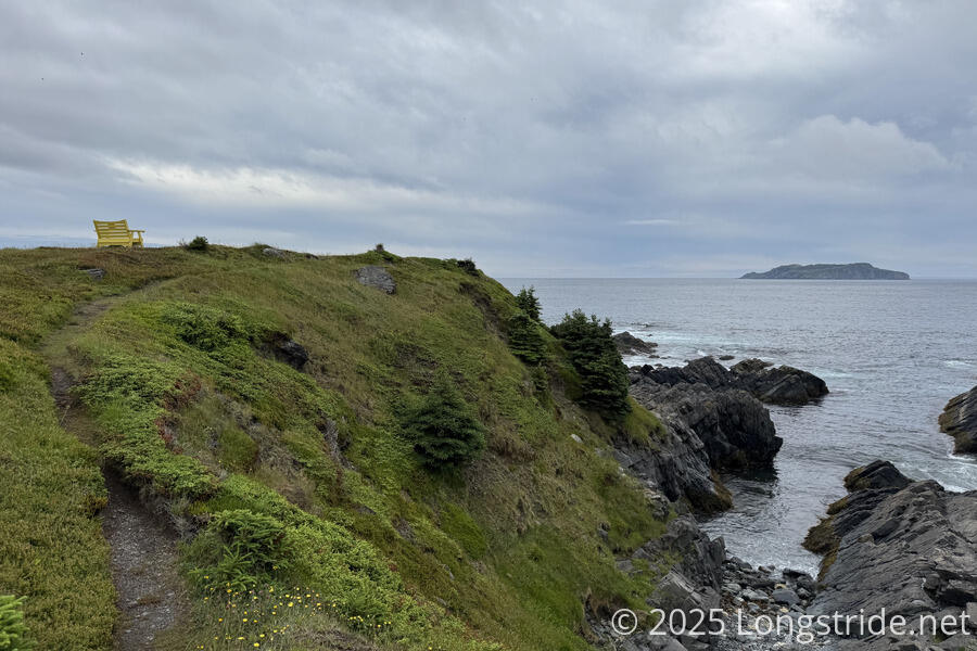
Tinkers Point Path was as easy as it claimed to be, taking us back out along the southern side of Mobile Bay, to its eponymous Tinkers Point, where a bright yellow bench provided a comfortable view towards Great Island. Along the way, we saw a few whales in the bay and out to sea, and plenty of seabirds.
Rounding Tinkers Point brought us along several small coves on the way to Tors Cove (both a cove, and a community).
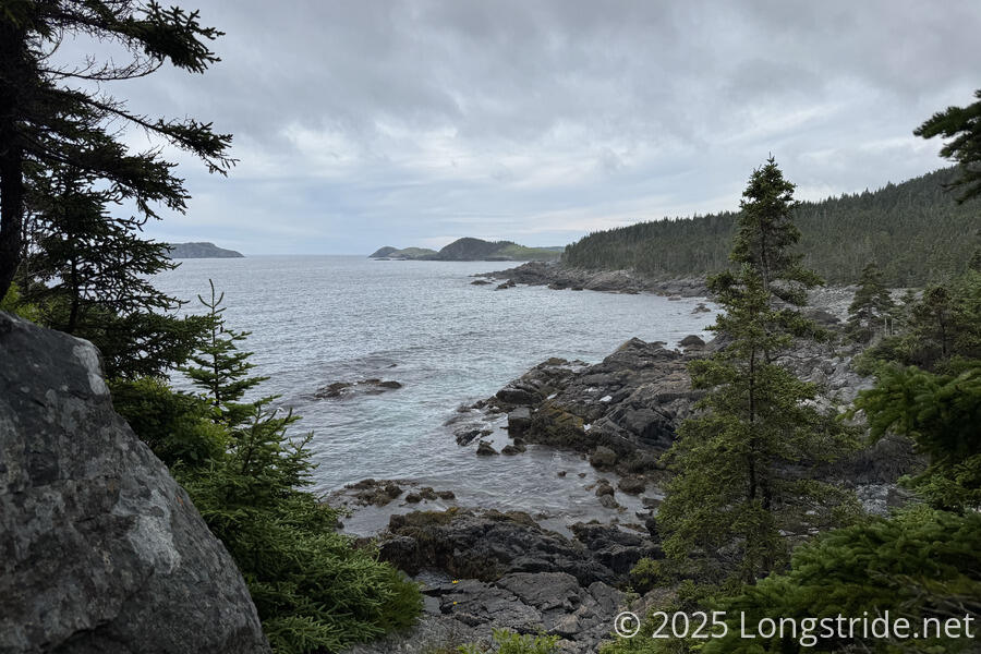
As we approached the community, Fox Island stood out, a mostly-bright-green cleared island, with a ridge of pines along its back. We passed two older women out for a walk down the trail to go bird watching.

It took less than fifteen minutes to walk through Tors Cove — it’s not a large place. Near the edge of town, we passed a water tower and pipeline for a power station. The pipeline from the tower had a significant number of leaks; I wondered just how much water (and thus, power) was being wasted there every day.
This brought us to the La Manche Village Path, which is perhaps the oddest path on the trail. Initially following an old gravel road for less than a kilometer, the path then joined a paved road for over 3 km, taking us through the community of St. Michaels. Turning at a junction at the end of the road in Bauline East, we followed another gravel road up a steep hill for another half-kilometer, eventually returning to actual trail and entering the La Manche Provincial Park for the rest of the way to the end of the path. This path took us somewhat more inland than we have usually been, and we were rarely near the ocean until the end of the path.
Along the road, we saw a few little chicks on the ground at the edge of the road. Seeing us, they disappeared into the brush. When CareFree got too close, a parent bird charged out of the woods, hissing and flapping its wings. I think the bird was a grouse, and the chicks looked the same as the ones I saw the other day, which made me wonder, if they were grouses, where was the parent?
Possibly our longest distance on the trail before stopping for a break, we took our first break in a small rocky clearing after almost 12 km of hiking. (Granted, all of it was easy trail or road walk, but that was more than half of our planned day by distance.) We saw quite a few people: two women from Quebec at the intersection at Bauline East whom we had a long conversation with, and a couple of families. Excluding the trails at Signal Hill in St. John’s, this was probably the largest number of people we’d seen on a path.
Now afternoon, it was still overcast, and the sky seemed a little darker than it had been this morning, a little cooler and more humid.
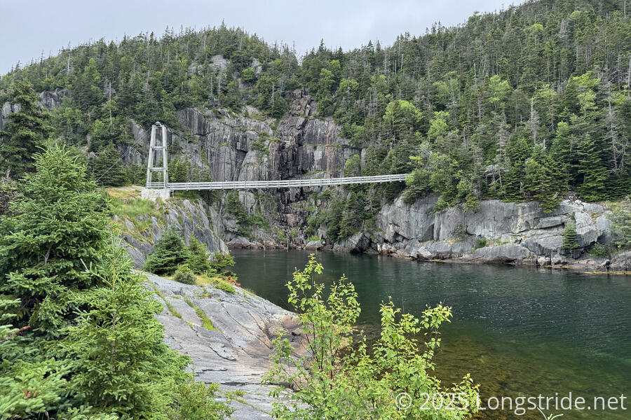
The path led us to La Manche Village, a fishing village abandoned in 1966 following a storm that demolished the community’s network of wharves and fish stages (used to process cod for salting and drying) and flakes (used to dry cod). Access was via a wooden suspension bridge, built in 1999 by the ECTA, since the previous bridge was demolished in the 1966 storm.
We missed actually walking through the ruins of La Manche; we were a bit laser-focused on getting started on the Flamber Head Path, rated as “moderate to difficult”. We still had almost 8 km to go to get to our campsite, and we wanted to get there before it started raining.
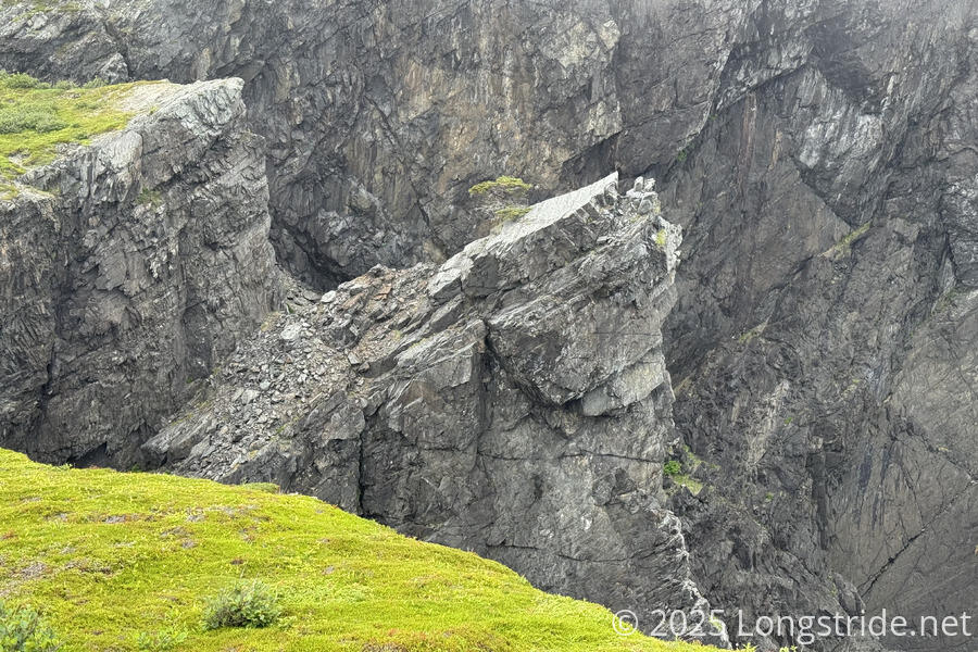
Flamber Head Path was immediately much more rugged than La Manche Village Path had been, with lots of short ups and downs. Unlike today’s two earlier paths, this path had plenty of overgrown sections, particularly towards the end of the day, and most of it was still wet from yesterday’s rain. Naturally, all this made it slower to proceed than we would have liked. Generally closer to the ocean than we were on the La Manche path, we saw several large flocks of puffins in the water, at least until the fog blew in. Occasionally, we thought we could hear whales offshore, but it was too foggy to see them.
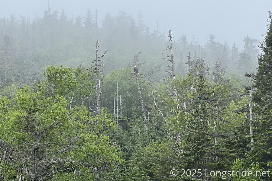
At the crossing of Freshwater River (yes, again; I’ve lost track of how many of those we’ve passed!), we saw a bald eagle sitting in a tree, much closer to us than when we saw one on the Spout Path. I hoped we’d be able to get even closer to it after crossing the river and entering the forest it was sitting in, but it flew away before we were able to get a closer view.
Not long after we saw the eagle, about half a kilometer from camp, it began to rain, with some thunder, a first for us in Newfoundland. The pine trees, which had been mostly behaving themselves, suddenly were quite thick and overgrown. Being already soaked from the earlier rain, by the time we got to the campsite, we were thoroughly soaked much more from the trees than the rain that was falling.
We arrived at camp, the Roaring Cove River Campsite, an official ECTA campsite, just before two other hikers who were heading north. They got lucky with their site, the only clear flat space large enough in the campsite to pitch a tent (two, even). The campsite had several tent platforms, all of which were rotting, broken, and generally unusable. We tried to make one work, but the platform just didn’t have enough usable space for our tent, and we had to relocate to the ground next to the platform, which might have been fine, except it was a quite cramped space, and one site of the tent had to be pitched in the grass. While I’ve stayed at a lot of bad campsites (including one not much better than this a few days ago), functionally, this is one of the worst official campsites I’ve stayed in on any trail I’ve hiked.
The rain was still going the whole time we were setting up, so not only were our clothes soaked, but the tent interior got somewhat wet as well. This made for a somewhat miserable while in the tent until we got changed out of our wet clothes into dry ones.
Fortunately, the rain stopped long enough to cook dinner. For that, I needed to get water from Roaring Cove River, just a minute prior on the trail (and, naturally, through wet and overgrown trees, though I managed to not get too wet in the process by taking time to thoroughly shake the water off the trees with a trekking pole on my way down and back). We’d hoped to try to dry out our clothes, and strung up some rope to use as a clothes line, but a light rain resumed as I was finishing cooking my dinner and put the kibosh on that plan. Later, after sunset, the rain was accompanied by a few flashes of lightning.
Tomorrow’s plan is for another long day, almost 25 km to another ECTA campsite two paths ahead. Hopefully, that campsite will be in better condition than today’s. At least, the weather forecast for tomorrow is much better — we might even get some sun!