A longish day took us to the easternmost point in Canada, as we continue to work our way south along the coast of Newfoundland.
We started hiking shortly after 9 am, not bad considering we needed to take an Uber to the trailhead parking lot and then walk another five minutes to the start of Deadmans Bay Path. It was overcast, but not foggy, at least not where we were. After a couple days of hiking with the sun shining directly on us, it was nice to have the sun hidden away a little, even if it meant the views were not the greatest.
A rarity on trail, we found a $5 banknote sitting in the bushes. We’ll put it to good use; probably laundry the next opportunity we have.
A steep uphill from the trailhead took us through forest and up to a somewhat open rocky area mostly filled with scrub. That’s we passed by a couple of ponds, we were greeted with a loud chorus of frogs.
Despite going through a somewhat boggy area, the trail itself was pretty dry, though, some of the plants on the uphill still were holding on to rain from last night, trying to soak our boots.
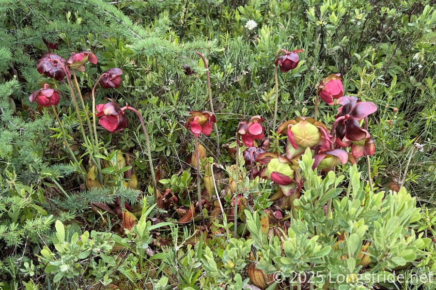
The bogs on the ridge had quite a few pitcher plants, many of which were flowering. This is the first time I’d actually seen flowers on a pitcher plant, and they were much larger than I would’ve expected.
A somewhat steep downhill back through the forest brought us alongside Freshwater Bay. On the way down, we passed a couple of streams that didn’t really have a lot of flow to them. Despite the rain last night, I’m a little surprised at how little flowing water there is around the trail.
From a distance, we could see the rock barachois separating Freshwater Bay from Freshwater Bay Pond. The trail crosses it, a significant shortcut to the trail along the perimeter of the pond. Fortunately, it looked intact; part of it had been washed out in the past, and presumably it can be flooded at high tide.

We followed the bay inland to the barachois. Crossing the giant rock pile took us a good 15 minutes, and was easily the most strenuous part of the day. Along the way, we were distracted by a pair of whales that had entered the bay and were swimming towards us. This was pretty exciting, because this was the closest whales had actually gotten to us so far, but it did make it a little more difficult to not trip over the rocks.
Once on the other side, we stopped for our first break of the day, and took advantage of the binoculars that CareFree got to watch the whales more closely.
The whales eventually started to move further out of the bay, but once we resumed hiking, the trail took us in that general direction also. For a while afterwards, we could still hear the whales breathing when they came up to the surface, even when we weren’t able to see them.
Later, as we approached the town of Blackhead, we saw two more whales (which could easily have been the same two) even closer to shore. Fog started to blow in from the ocean.
After a brief walk through Blackhead, we joined the Cape Spear Path. Starting with a nice forest trail, we began a climb up a rough rugged path. We could hear the ocean, but no longer see it through the fog. A foghorn started sounding in the distance. I assumed it was from Fort Amherst, since I saw a sign there warning about it, but otherwise couldn’t really pinpoint the direction the sound was coming from.
The tip of one of my trekking poles pulled out on this stretch; probably it was loosened going across the rock bridge, and then pulled out in some thick mud next to the trail. (I looked briefly, but couldn’t find the tip on the ground.) Fortunately, CareFree was carrying a replacement tip, so we stopped for a minute to put it on. Otherwise, the bottom segment of my pole would have gotten chewed up on the rocks, and I’d have to replace it entirely.
From there, the climb up to the road leading to the Cape Spear Lighthouse was slow and frustrating. Knowing there was a cafe there, we were pushing a little longer between breaks, and it took us a lot longer than we expected.
Near the road, the trail veered off to cross a parking lot, and then branched out into a network of paths the rest of the way uphill to the lighthouse. A sign warned some of the trails were closed due to coastal erosion. Fog continued to blow in, and visibility was limited; we kept quite far away from the edge of the cliffs on our way up.
The trails that weren’t closed eventually led us to an observation platform with various displays, and a monument to being the easternmost point of Canada!

Also nearby were gun embankments from WWII, but we didn’t linger there long; we needed a break, and Cape Spear Cafe was calling. The walk to the cafe went past Cape Spear’s foghorn, which was the one that had been sounding the last few hours. (It was quite loud walking past it, it it wasn’t too bad once we were at the cafe and clearly behind it.)
We stopped for a break at the cafe, briefly chatting with two other hikers heading north. We both got a very tasty hot blueberry cobbler with ice cream, which was nice to warm us up a little.
We were surprised to find it was already after 4 pm when we stopped (and nearly 5 when we continued again).
Heading south from the lighthouse, we were very surprised by just how great the trail was. A few boardwalks in poor repair aside, this might have been the fastest we hiked for any length on the ECT that wasn’t on a road.
We got a lucky view back to the lighthouse. When we left, the clouds were retreating a bit, but as we continued, the fog was rolling back in over the cape, and the lighthouse was nearly completely engulfed in fog from our view.

Ahead, we were quite happy with our view, relatively unimpaired by the fog. It was a very different landscape to what we had been seeing, with the trail following one ridge, and a relatively treeless river valley separating us from the next ridge over.

Turning to the southwest as we approached the end of the small peninsula we were on, we came much closer to the coast, and could hear (and sometimes see) a very rough ocean bartering the coast.
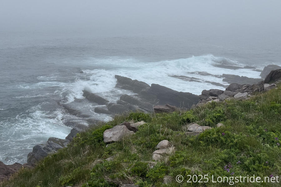
In some places, we could even hear rocks on the beaches grinding against each other as water retreating after a wave pulled them towards the ocean. (And some of those rocks did look rather round and smooth.)
Finding a campsite was more difficult than we expected. We passed a nice one since it was only 5:30 and we still had plenty of daylight (sunset is still after 9 pm). We were looking for another described campsite, but having only a general description of its location, we were rather unsure where it was.
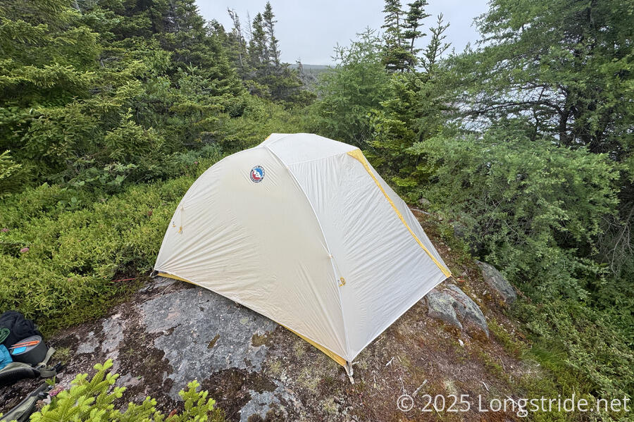
Around 7, we reached a place we thought might be it, though it was rocky, tiny, cramped, and definitely not “2 or 3 spots”. Hoping for something better, we continued another ten minutes, through some steep and very rugged trail, stopping at three large boulders it looked like we’d have to climb and deciding that we’d spent enough time looking, and it was time to go back to the site we’d found.
It took some doing, but we managed to cram our tent into the space available, only able to use one of our doors because the other opened into dense foliage.
Tomorrow, we’ll finish the Cape Spear Path, go through the towns of Maddox Cove and Petty Harbour, and start on the Motion Path, which when combined with the adjacent Spout Path, forms the longest (30 km) stretch of trail on the ECT without going through a town.