Today was a long, arduous trek through water and steep hills, before turning into some of the most well-built trail I’ve ever seen. (Followed, of course, by a road walk.)
I didn’t sleep all that well last night. I woke up at 2 am to go pee (which was a bit awkward since I didn’t want to get wet, and never really got back to sleep. The rain continued, and wind picked up around 4 am, blowing out one of our tent stakes (which we didn’t really get pushed into the ground too far because the ground was actually very hard; now, it was much softer), and allowing a small puddle of water to collect in the foot of the tent, soaking the foot box of my sleeping bag.
We were’t the only people to have tent problems around the time either. While I was mopping up the puddle and CareFree went outside to fix the tent, I saw several other headlamps outside at the same time, presumably fixing their tents as well.
The route I took today is not advised if there was recent “heavy rain”. Naturally, there was some debate over what exactly that meant, in the context of the light rain that fell mostly-continuously for twelve hours overnight.
Many of us gambled that that the rain that fell wasn’t going to be a significant problem, and decided to forge on along the trail route. CareFree, however, was understandably nervous, and opted to take a detour, which involved over 35 km of road walk and a bit more elevation gain.
I didn’t want to take the detour — another 30 km of road walk involving some backtracking would have made my feet extremely unhappy, but I would have if there hadn’t been a group of three younger hikers leaving at the same time as we were ready to go. (I’d have preferred to do this section with Susanna, Peter, and Shaun, but they’d already left a little before we were ready.) So CareFree headed back along the dirt road we came from to take the detour, and I started downhill.
Before going further, we had to go through a Kauri Dieback Station, a two-way metal contraption blocking the trail that includes first a boot scrub, then a step-on disinfectant sprayer for the bottom of your boots, meant to reduce the chance of infected soil being transported from one area to another, spreading the dieback disease.
It took about 25 minutes to reach Mangapukahukahu Stream from the campsite, through mostly steep downhill trail. It was occasionally muddy, though did not begin to approach the muddy mess we encountered in the Raetea Forest the day before yesterday.
Once at the stream, we very quickly got our feet wet. Knowing that this would be an extended stream walk, with a rocky bottom (unlike Te Paki stream which was sandy), I opted to keep my boots on. My boots and socks would get completely soaked, but it would be much easier walking, and, at least after getting them terribly muddy two days ago, by the end of the creek, I’d have clean boots.
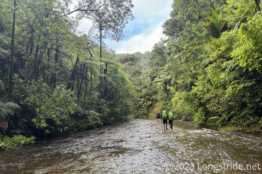
The stream was not too difficult to walk. It was usually ankle-to-shin deep, occasionally knee-deep, and twice for a short stretch, up to my crotch. The water was also not cold. I wouldn’t have wanted to stand in it for a long period of time, but I wasn’t cold walking through it. Every so often, we were able to leave the stream and proceed on the bank, which was usually a little faster. It was a little muddy, which made it a little harder to tell how deep it was, but fortunately, that’s what I had my trekking poles for.
The stream was in a small gorge, somewhat similar to the Gila River on the CDT, but on a smaller scale. Lush forest lined the hills on both sides of the stream. It would have been beautiful to look at, if I hadn’t been quite as concerned with keeping my footing while wading through the water.
After a little more than an hour in the creek, we reached the confluence of the stream and the Waipapa River, which the trail then followed. Unfortunately, because of the extra water from the rain, the river was too deep and flowing much too swiftly to cross — one of the hikers I was with got into the water to try and cross, and wound up nearly getting swept away, only just managing to hang onto a branch to steady himself. If it hadn’t been for the extra water from the rain, we could probably have just walked down the river. Instead, we had to find a path on the side of the mountain. This was a little difficult, because trail markers were missing or hard to see, but eventually we found a correct path forward, which put us far enough downstream from the confluence that we were able to cross, and then head upstream on the hills alongside the Waipapa.
We also caught up with Shaun, Susanna, and Peter at this point.
Once we continued following the trail, we found the trail markers on this trail to also be missing or unhelpful. Shaun and I, lagging slightly behind the rest of the group, took a wrong turn somewhere, and wound up climbing up (likely an old trail) to get around a fallen tree, and then we (though really, mostly me) had a difficult time climbing back down, due to the steepness, slickness from the rain, and in my case, what turned out to be way too much food in my pack due to a combination of buying more than I needed in Kaitaia and accidentally packing one of CareFree’s bags of nuts in with mine. This incorrect detour easily cost us half an hour. Susanna and Peter were kind enough to wait for us. I was glad they did; I was fairly exhausted by this point.
Twice on that section, when jumping over small crevasses with flowing water at the bottom, my water bottle jumped out of my pack and landed in the water. In both cases, other hikers went in to get my bottle, since I couldn’t see an easy route to get it. The second time, I was ready to call the bottle lost, since it was a much deeper crevasse and I didn’t think it reasonable to try and retrieve it, but Shaun happened to find a safe way to get to it that I just wasn’t able to see from my vantage point. I definitely owe him a beer now.
Somewhere in that section, after sliding down on some mud a bit, I also bent one of my trekking poles, which is a bit disappointing, given how early in the trail it is.
We continued on, occasionally on a superb set of boardwalk built over the old trail. We marveled at how difficult it must have been for them to build it. (I was too exhausted to take good pictures of this fine example of trail maintenance.)
After one more (but short) water crossing, we followed, for the first time today, some actually nice trail. After leading us uphill for a short while, we reached a long, steep climb, climbing up on one of the finest examples of trail maintenance I’ve ever seen. For at least half a kilometer or more, gaining 200 meters, the DOC had built a wooden staircase filled with gravel. Let alone the difficulty in building the staircase, the sheer amount of wood and gravel needed was enormous, and we couldn’t fathom how it could have all been transported without dozens or hundreds of people hauling gravel, either up from the river, or down from the road at the top.
Once we’d finished climbing the staircase, we continued climbing the mountain (though less steeply), until we reached what must have been a two kilometer long gravel path. (In retrospect, it was probably so that wheelbarrows could be used to haul gravel closer to the staircase. In any case, it was quite a reward after the water hiking, the terrible hillside trail, and the steep staircase.)
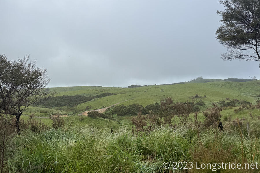
The gravel path brought us to a dirt road, which we followed another 9 km to the Puketi Campsite. Shaun passed me, since I was pretty worn out from our adventure on the hillside. Susanna and Peter lagged behind, trying to reserve a campsite while they had cell service at the top of the ridge, then caught up with me while I took a break.
The road wound through the mountains, occasionally giving a view of nearby meadows.
On my way to the campsite, I saw two rabbits (an invasive species in New Zealand). I also saw my first “Kiwi Zone” sign: dogs are not allowed in some areas, since they are likely to attack or kill the flightless birds.
I finally arrived at the campground at 5 pm, a ten hour day for only 20 km gained. Everyone else that was heading there via the TA had arrived before me, save for Susanna and Peter, who camped a couple of kilometers before, due to not being able to reserve a campsite.
The campground had plenty of space for camping (including for Susanna and Peter, despite them not having a reservation). It also had an 18-person hut, which was not available, though we saw no evidence of it being used. There was also two bathrooms and a shower, and a small picnic area with a cramped octagonal table.
CareFree was the first to arrive from the detour, getting there about fifteen minutes after me. (I was glad I got there first; that way she wouldn’t get there and be worried I hadn’t gotten there yet. But I was able to send her a message once I reached the road at the top of the ridge, and got a message from her as well, so we both knew the other was ok.)
We set up our soggy wet tent, cooked dinner, and turned in after sunset. It was a long day, and we were both tired. We’re quite looking forward to reaching Kerikeri tomorrow, where we’ll have our first zero.