Today’s mix of road, forest, and park trails brought us to Kerikeri, where we’re stopping for a much-needed day of rest.
We started off from the Puketī Campground, and pretty much immediately made a wrong turn, going down the detour CareFree had hiked yesterday. We only realized it as quickly as we did when we saw two other hikers walking back towards us. It only cost us five minutes of hiking, though.
The dirt road we were on continued through farmland. Recent sprouts were bright green, contrasting against the dull gray clouds.

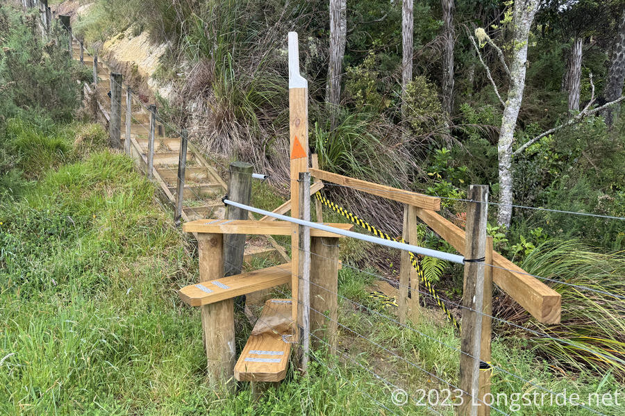
At the 200 km marker, the trail entered one of the farms it had been running along. I saw a new (to me) type of stile, meant to allow hiker access while preventing animals from passing. A few planks of wood around a vertical support pole make for a short circular staircase up, over, and down the other side of a (possibly electric) fence.
Light rain briefly fell, and we wandered on the border of a cow pasture for about half an hour. CareFree abruptly stopped to take off her red pack cover, so as not to startle the cows, separated between us by an electric fence and not much distance at all.
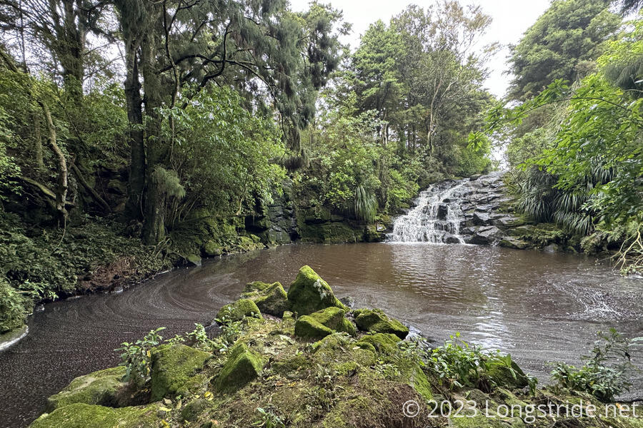
The trail entered a forest, which was much nicer than the (somewhat overgrown) grassy trail along the pasture. We were quite unprepared to see a waterfall nestled in the forest. It seems weird to me that a corporate farm has this hidden gem, but I’m just glad TA hikers are able to see it.
We stopped for a snack break just before exiting the forest, hoping that the tree cover would protect us from threat of rain and giving Shaun the opportunity to pass us.
Another gravel road split farmland and pastures on both sides, with a fair number of property for sale signs. (I don’t know much about the NZ land market, but the land prices seemed very expensive for being fairly remote.)
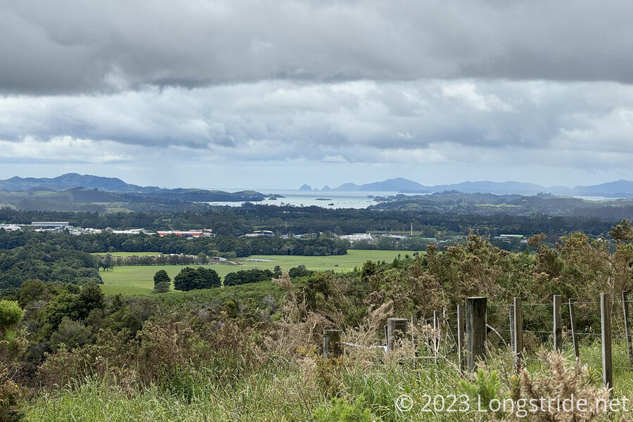
While on the gravel road, we got our first view of the Bay of Islands, a bay on New Zealand’s northeast coast with 144 islands. Shrouded in distant clouds, it gradually became more visible later in the afternoon as we got closer.
I also dropped my phone in this stretch while taking it out of my pack, cracking my screen protector and damaging the case on the gravel road. Fortunately, my phone itself seems undamaged.
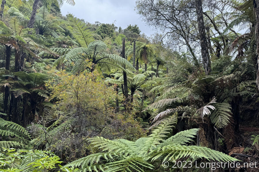
The trail entered another corporate farm, with another forest in the middle. A deep gully filled with lush ferns evoked memories of Jurassic Park.
When the trail entered the gully, it started following a creek that, after merging with two further larger water bodies, became the Kerikeri river. It then followed the river the rest of the way into town.
We caught up with Shaun in the middle of the fern gully, and invited him to lunch at a Thai restaurant just off the trail, on the way into Kerikeri. Our feet were hurting, and we were very much looking forward to a good meal and getting off our feet for a long break.
Exiting the gully, the trail had another set of quite excellent gravel staircases, comparable to the staircase in the Puketī forest, though at least a season or two older.
We stopped for a snack at a picnic area along the trail, more to rest our feet than because we were hungry. (And also to let Shaun catch up with us a little, so there’d be less waiting at the restaurant.)
After the picnic area, the trail followed a recently renovated section of track sandwiched between the river and tall, shady trees. It was a quite lovely section, and well-built. In spite of my now quite-aching feet, we made good time.
In the distance, we could see a large building I decided must be the Thai restaurant. As we got closer, though, several large closed signs came into view. Today is Monday, and that’s the one day of the week the restaurant was closed. Bummer. CareFree texted Shaun the news, just in time for him to appear right behind us.
From there, the TA joined a track in a local park alongside the Kerikeri river, separating the river from houses. (Further on, fences separated the trail from the houses, and a short stretch had a hastily improvised privacy fence.)
The trail continued on an asphalt bike path above the river, and arrived at a small seating area just before a waterfall on the river. I immediately went for one of the benches to sit down and take my boots off for a little while. Almost as if on cue, it began raining, and I also had to put on my rain jacket.
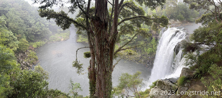
A bit further on, the trail came to another viewing area, providing a great view of Rainbow Falls and the large pool of water at its base.
Near the end of the park, the trail brought us to an old hydroelectric power station, originally built in 1929-30 and powered from water channeled from above the falls, to service the needs of the wives of retiring British civil servants originally based in Asia, who were used to having household servants, which they couldn’t readily obtain in New Zealand. (Electricity was a suitable alternative.)
CareFree went into the power station; I took a quick peek in, but seeing the same display as was at the overlook before the falls, I declined to enter. My feet hurt so much that shifting around outside was preferable to standing in place for a minute or two.
A trail heading uphill from just after the power station appeared to exist only in the imagination of the map I was using to plot a route to the cottage CareFree had arranged for us, and a reroute added another kilometer and a half, much to my feet’s dismay.
The trail diverted from the river towards a car park, providing us an actual exit from the trail to our cottage, and we said bye to Shaun. He was staying at a hostel in town, which we’d attempted to book, but which no longer had private rooms available.
Departing from the trail, we headed a kilometer and a half away from town to the J & D Cottage, a one-room-plus-bath addition to the house of our hosts, John and Diana.
They very generously offered to give us a ride into and back from town tomorrow, and back to the trailhead on Wednesday.
They also let us use their clothes line to hang all of our wet stuff. It was quite windy out, so everything we hung up, including, most importantly, our tent, dried out very quickly. (We ran out of space on the line and had to dry our sleeping bags by laying them out on the driveway in the sun, weighted down by rocks. They also dried quickly.)
Dinner was Thai food, but delivery, with surprisingly huge portions.
After a week and a half of hiking — during which time we hiked 233 km, much of it on roads, we were exhausted. Tomorrow will be a well-deserved day of rest.