A very varied day with several river crossings and a high-elevation mountain pass brought me to another valley in preparation for even more river crossings tomorrow.
It was cold out overnight, and my tent collected a bit of condensation by morning, but it had all dried out by the time I packed it up, thanks to the morning breeze.
After a brief initial climb and descent, the trail was largely flat for a few kilometers. As it traveled along a plateau, in roughly a straight line alongside the fence line for what seemed to be a pine farm with very few live trees, it approached the Ahuriri River.
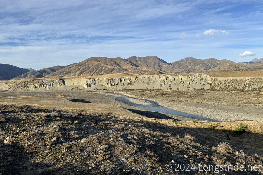
As I approached the river, it became clear there was going to be a steep drop from the plateau down to the river (and a correspondingly steep climb back up to the plateau on the other side of the river. On my way down, I could see Nikki and James in the water, halfway across the river. I made a mental note of where they crossed, since it appeared only to be knee-deep. Once I got a bit closer, James (now on the far bank) let out a pretty good whistle to get my attention, and then pointed to where I should go to cross, and how to cross.
The Ahuriri River is supposedly the largest unbridged river on the TA on the South Island, in “normal flows”. Clearly, this was a low flow, because it was not at all difficult to cross. Pictures of a diagram in Top Timaru Hut had been circulating for most of the South Island, showing the safe route through 1 meter deep water, which involved crossing in a particular place to an island, traversing to the lengthwise far side of the island, and finishing the crossing. The three of us were briefly in bottom-of-pants height water, and then in knee-high water for the rest of the crossing. It wasn’t difficult at all; most of the braids of the Rangitata that I crossed were deeper and more difficult to cross. So I’ll just count myself lucky that it hadn’t rained in a while so water levels were low.
Climbing out of the river’s gorge was more difficult than the river itself. It was a steep climb on somewhat slippery loose dirt up about 40 meters. At some point, I got off-trail by following someone’s footsteps, and made things more difficult for myself than necessary, but I made it to the top without too much difficulty.
After that, the trail followed the edge of the gorge briefly before turning to follow a dirt road along a fence line, leading to a trailhead car park.
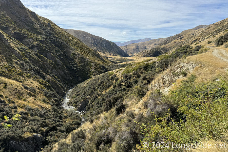
Beyond the car park, the trail continued to follow a farm road, leading down to the Avon Burn, a small river. After zig-zagging through trees with plenty of nice campsites (provided there was a flat area without cow shit on it), the trail reached the river, and crossed it a few times. On the first crossing, I’d made it about three-quarters of the way across, before running out of exposed rocks to hop across, and had to get my feet wet (again).
Shortly after, I stopped for a break. James and Nikki passed separately, not hiking together today.
After another half-hour of following the river, the trail steeply climbed up from the Avon Burn and joined a dirt road, which it essentially followed for the rest of the day.
The road wound around the mountainside, gradually gaining elevation. It was easy to follow, and not at all steep, and I made great time. I passed Nikki on a break while I short-cut the road, cutting off a wide turn around a marshy area by following a trail just above the marsh.
After an hour on the road, I reached Tin Hut, a private hut owned by the cow farm the trail was currently passing through, but available to hikers for a nominal fee. I stopped inside just long enough to sign the logbook, and continued on, not ready for a break.
Five minutes later, having started the day’s lengthy steep climb, I decided I really should stop for a break.
Nikki passed while I was packing up from my break; I caught up with her a while later.
Still a road (or at least, an old road bed; I doubt anyone actually drives up here), the trail gained nearly 1,000 meters of elevation to the pass at Martha Saddle. Along the way, I passed Hannah, who had flipped to Wānaka (the next trail town) to deal with a broken tent, and was hiking back to Lake Ōhau Lodge where she left off. I also passed another northbounder, who mentioned that there was supposed to be rain tomorrow, and that he didn’t envy my hike tomorrow. (Because I will be going through a river. Again. sigh)
It had been nice out for most of the day, but as I approached Martha Saddle, it gradually grew colder and windier. This was a long climb, and quite tiring, even without the wind. At least the trail was mostly fine on the old farm road it followed. It seemed incredible, though, that anyone would have cleared and graded a road this long and steep this far into the mountains to go over the pass, but if you’ve got a farm on both sides of the mountain, you need a way to get across, even if it is long and steep. At least there were switchbacks, after a fashion.
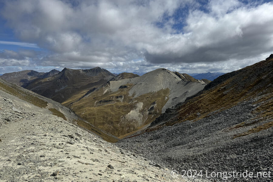
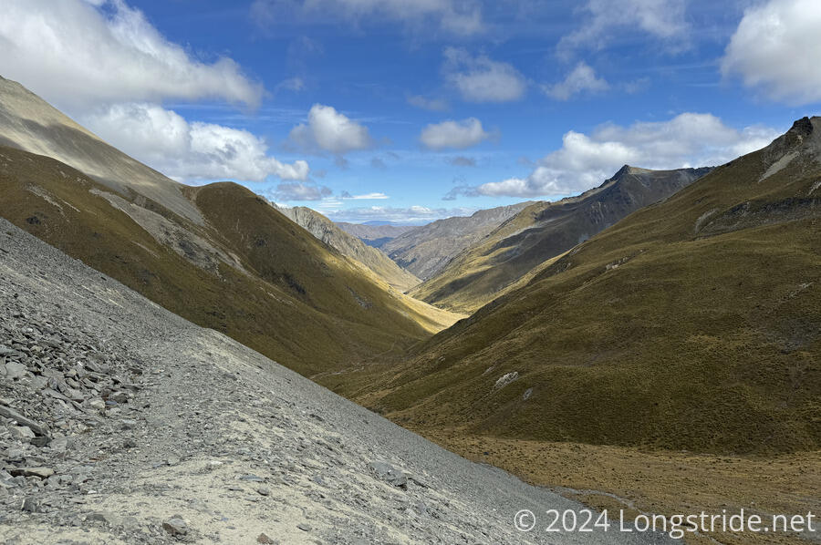
Eventually, I reached the saddle, which had good views to both sides.
There was one good thing about the wind: it helped dry out my shoes. They were nearly completely dry by the time I reached the saddle.
The descent was initially just as steep as the final part of the ascent, down a narrow trail with wide switchbacks. The wind didn’t really die down much until I got most of the way down the steep descent, at which point there was enough shade from being lower into the Timaru River valley to dull the wind.
The trail was generally easy to follow, with a few small stream crossings and muddy areas, but nothing too bad.
Going through some reasonably nice trail lined with overgrown tussock, I lightly sprained my ankle while I was pushing towards Top Timaru Hut. I was going to just walk it off, but thought better of it; I hadn’t had a break since I started the steep climb, and that was over three hours earlier. Better to stop now than risk compounding the problem from being more tired.
it was then that I noticed that one of my trekking pole tips had fallen off.
I had a reasonably narrow range of where that might have been; I’d just recently crossed a small creek on the trail, and would have noticed missing pole tips then. So I retraced (several times) my steps between where I stopped and that creek.
After nearly fifteen minutes of looking for the pole tip somewhere next to the trail, in occasionally thick grasses, I gave up the search. I’d have to get CareFree to send me replacement pole tips to Wānaka, and hope I could manage the trail until then with just one pole. (Trekking pole tips are carbide metal, very hard. By contrast, what they attach to on my poles is aluminum, which is not very strong in comparison. Using the pole without the tips would just wear that segment of the pole down to the point that I couldn’t put new tips on at all.)
I sat down and ate my snacks, and then did one last pass to see if I could find it anyway. I didn’t. As I put my pack on to continue, Nikki came over the hill, and I waited for her to catch up to me to ask if she’d happen to have seen the missing tip. She hadn’t, so with that, it was definitely lost, and I continued on.
Just under an hour later, I made it to Top Timaru Hut, to find the hut over-full. There were six bunks, all claimed, and two more of us wanting to stay in the hut by sleeping on the floor. For me, tenting wasn’t an option. With one of my poles missing its tip, I’d risk damaging the pole if I used it to set up my tent.
I almost started cooking dinner in the tiny vestibule outside the hut, which had half a dozen foldable chairs. But, the sandflies were pretty bad — worse than they’ve been since Arthurs Pass — and I retreated into the hut to cook.
Using the InReach, I coordinated with CareFree to order me a new set of poles in Wānaka. There was an outfitter that had tips, but now that the tips have pulled off one of my poles three times (once in the Richmonds, the other day in transit from Tekapo, and today), I don’t trust that the one pole will be able to successfully hold a new tip. The outfitter can’t do warranty replacements on-site, they have to send the poles back to Leki (in Germany), so I’m going to mail my “old” poles (that I just got in Wellington!) back to Auckland and deal with getting them serviced later. (This is a bad trail for poles! I’ll soon be on my third set. Despite my bad luck with them this trail, though, I’m still quite happy with them overall.)
With a long (time, not distance) hike planned for tomorrow, to Stodys Hut, I again turned in early. The weather forecast is calling for a little rain tonight, and perhaps some rain around noon tomorrow, which might be problematic since there will be numerous crossings of the Timaru River.