A climb up to Breast Hill and then steeply down to and along Lake Hāwea brought me, at least for now, out of the mountains.
It was very cold overnight. I didn’t get up until after 7, and didn’t leave Stodys Hut until after 8:30. Even then, it was still quite cold outside, and the sun hadn’t yet risen above the ridge.
Since we didn’t light a fire last night, none of my clothes from yesterday dried out. Not wanting to put on wet clothes to go hiking in the cold, I put on dry clothes instead. I had an extra pair of pants, and plenty of socks, but I only have the one hiking shirt, so I left on my town shirt (short sleeve), and put on my fleece and puffy to stay warm.
Leaving the hut, the first thing the trail did was cross a steep slope with a slip, with the trail being just barely wider than the width of my foot. It would have felt very unsafe if I didn’t have poles, and I wondered how DOC could put in the effort to maintain the hut and its toilet without bothering to widen the trail even a little.
About ten minutes after I left the hut, the sun had finally crested the ridge, which almost instantly made it too warm. I took my puffy off — I didn’t like having to hike with it on anyway — but kept my fleece on. With the next while being a moderately steep uphill on an old farm track, I assumed I’d have to stop again soon and take it off.
There was still some snow on the ground from yesterday, though not really very much to worry about.
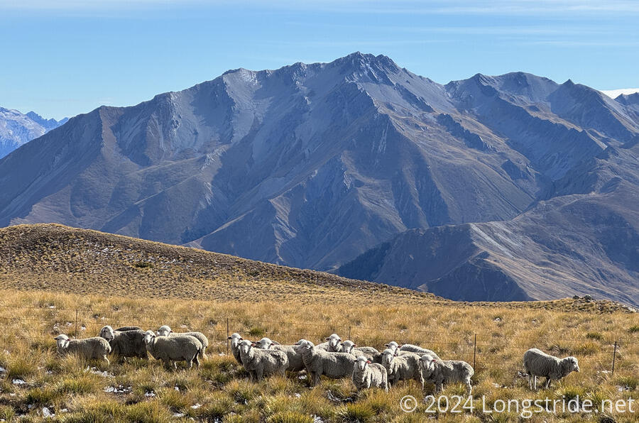
After about an hour, the trail exited the Hawea Conservation Park, which I entered two days ago when I crossed Martha Saddle. There were signs indicating the trail was entering a working farm (a sheep station), but even without the signs, it was fairly clear that there were sheep around: in places, the sheep droppings on the trail were so thick you couldn’t avoid stepping on them.
A later sign requested that people NEVER pick up the lambs. It was sad to think that a sign like that was necessary.
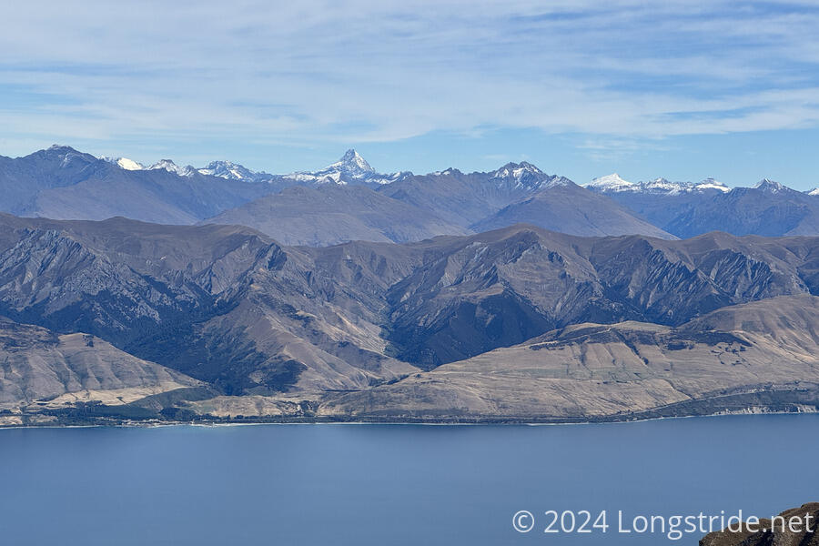
The steady climb up the farm road gave gradually improved views of the mountains all around, but especially to the west, towards Mount Aspiring National Park, where many of the mountains were snow-capped.
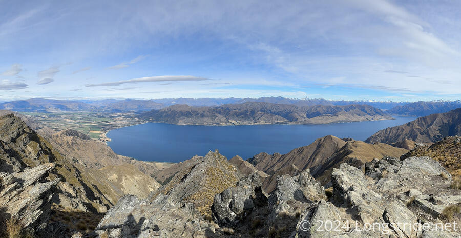
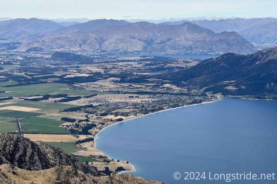
The high point of the day was Breast Hill, my first mountain summit in over a month. There were great panoramic views of the Aspiring Range, and also of Lake Hāwea and the town of the same name. Between the two, I could even see Lake Wānaka and the town of Wānaka.
I stopped for a break there for a while, catching up with Isabella, who was just getting ready to leave. Nikki and James had left a few minutes earlier; I saw them following the ridge ahead when I was almost at the top.
With visibility of town, I had cell service, and coordinated with CareFree for lodging today and tomorrow. While I was on my way uphill, she was able to book me nearly the last bunk at the hotel/hostel in Lake Hāwea. She was also able to book me two nights at a hostel in Wānaka — it’s been nearly two weeks since my last zero in Methven, it’s time for a break.
As I was getting ready to leave, Jill and Steve arrived, and also three day-hikers who hiked up to the summit from the trailhead.
From Breast Hill, the trail followed the ridge (and a fence line) downhill, towards Pakituhi Hut. It was a bit steep at times, but generally was fairly easy trail.
Towards the turn-off to the hut, the trail became a bit confusing, and it was unclear which way I was intended to go. Jill and Steve were not far behind me, so when they caught up, we finally figured out which way to go. I think we wound up following someone else’s shortcut, rather than just following the more clear trail, which was longer but looked much easier.
From this junction, the trail began a steep descent, initially along a narrow, sometimes rocky ridge, which occasionally required a little scrambling to get down. It was slow, but steady progress.
The three day hikers we saw at the summit passed us on the way down, and several others passed us going up to the summit. I wouldn’t exactly call it busy, but there were more people on trail than I have usually seen on the TA.
Steadily progressing downhill, it gradually got warmer. It was a nice change from this morning, except that I was getting too warm, since I still had my fleece and pants legs on, and there was nowhere to stop and take them off.
After over an hour on the steep descent, there was finally a small outcrop where I could sit down for a bit. Surprisingly, I was only about halfway down to the trailhead. But, I could finally take off my fleece and pants legs, which was great, because I was sweating. That also meant my town shirt was now dripping with sweat too. I swapped it for my hiking shirt, which wasn’t dry, but was fine given how warm it was.
From that outcrop, the trail was on the ridge for a little longer, then took switchbacks the rest of the way down, much easier than the ridge was.
Once I reached the trailhead, I found Nikki and James, and Jill and Steve, and a cooler with cans of soda, much welcome trail magic from Ben & Alex. I was going to stop for a break at the trailhead anyway, but cold soda made it even better.
From the trailhead, I followed a road for a short while, then joined the Gladstone Track, a gentle cycle path that took me the rest of the way to town, generally following a terrace above Lake Hāwea. I was running out of steam — the descent was quite tiring — so this was a bit slower than it should have been. I was also burdened by having way too much food. I’d brought five days of food, but I could have done with a day or two less: I’m in town tonight and tomorrow night, so I didn’t need to carry dinner or breakfast for those days.
After a shower, I joined Mikkel, Isabella, and Masako for dinner. They’re planning on taking an alternate route after Wānaka, going through the Mount Aspiring National Park, rather than following the TA to Queenstown, so that they can “stay in the mountains” longer, and also maintain a continuous footpath for longer. Beyond Queenstown, the trail is once again discontinuous, requiring road transport around Lake Wakatipu because the only path — via the road — is too dangerous to walk. This is the last of the discontinuities on the South Island.
Tomorrow will be a long, but relatively easy, day to Wānaka. I’m quite looking forward to the zero once I get there.