I woke up this morning to the smell of rain. The rain last night never reached me, but that unmistakable smell wafted into my tent, along with a bit of humidity.
I’d wanted to start hiking at 6:30 am, right around sunrise, to not waste the coolest part of the day. Despite setting an alarm earlier than yesterday, I didn’t manage to leave camp until a few minutes before I did yesterday. An improvement, I guess, even if small.
On the trail, seemingly in the middle of nowhere, sat a rusty car wheel. Later, on the side of the trail, there was a rusty muffler and tail pipe. One wonders how they got here, and also, what happened to the rest of the car.
I passed by a couple of southbound hikers. Apparently, it’s a thing for northbounders to hike from Lordsburg to the terminus when there aren’t enough spaces on the shuttle to the terminus on their desires start date. Which makes sense, I guess, otherwise the shuttles have to return empty.
After a couple of miles, I reached an empty bit of trail magic, a cooler (no longer) full of ice-cold Gatorade bottles. But the cooler was full of ice-cold ice water. I dipped my hands in for a bit to cool off and splashed some cold water on my face. It felt wonderful. It’s definitely hotter than yesterday, and there’s less wind to help moderate the heat.
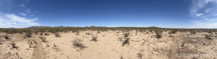
After running through the foothills below Hachita Peak, the trail joined a dirt road, and began cutting cross-country across relatively flat terrain. You definitely do get the feeling you’re actually going somewhere, because the perspective to mountains in the distance constantly changes.
I stopped for my first break after about seven and a half miles. This was further than I’d planned, but the relatively flat trail makes the hiking much easier. I sat down underneath a small bush, which provided just enough shade to make sitting there worthwhile.
I saw my first horned lizard on the trail this morning, but by the time I got my phone out, it had already attempted to hide under a bush, and I couldn’t get a clear photo.
My next important stop was the third CDTC water cache. Naturally, there was no shade at all there, but a large tree about a mile before the cache would have been a great place to stop if I’d been hiking southbound.
Just before the (very short) side trail to the cache box, there was a fence stile with barbwire, situated too narrowly to allow me to squeeze through without taking off my pack.
I took 7 liters from the water cache, and again burdened by fifteen pounds of water, headed off into the desert.
Wait, did I say desert? I meant cow pastures. For reasons not entirely clear to me, there are lots of cow pastures here. It must be because it’s wide open space that’s otherwise not good for much of anything. Most of them don’t have any cows (but lots of cow droppings), though today I saw two groups of about a dozen cows each.
In need of shade so I could take a break and cook dinner, I took a slight diversion from the trail, down a road that had a water tank (for cows). I didn’t want the water; just the shade that was supposed to be there. And there was shade, at least a little bit under a small tree, but there were also cows, and a lot of cow poop, making it an entirely unsuitable place to stop. In retrospect, passing by cows twenty minutes earlier by a different cow water source with no shade should have suggested this was not likely to work. But, I don’t think it actually added any distance, since the road reconnected with the CDT further north.
Just after the road reconnected with the CDT, though, was a small grove of trees near the “Vista Tank”. (I never actually saw the water tank, and it was unclear what vista was being suggested. Maybe the vista of trees in a desert?) A couple from the Czech Republic I’d met on Monday was under one of the trees. I found another tree nearby and sat down, careful to avoid the cow droppings that were plentiful in the area.
I spent about two hours under the partial shade of a tree, and cooked dinner, and drank a lot of water, greatly reducing my load to carry. While I was eating, large bees were flying around, collecting pollen from the tree’s flowers. Occasional gusts of wind blew the bees off course, and sent (I think) moths flying when they lost their grip on the trees in their sleep.
While taking my break, I noticed that the next water cache was “only” another nine miles ahead. I decided that would be a stretch goal for the evening. Leaving my break spot just before four, I figured I’d still be able to get there before sunset. Otherwise, I was aiming for a campsite about three miles earlier.
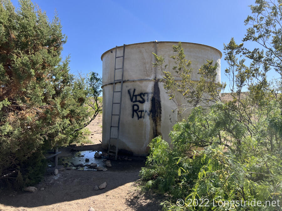
From the grove of trees, the trail climbed through the mountains, and the wind gradually picked up. At the highest elevation of the day, I passed a large water tank with “Vista Rim” spray painted on it. The tank overflowed from its drainage spigot, creating a small desert oasis and watering a few well-growing trees. It would have been a nice place to stop, had it been more than half an hour away from my previous break.
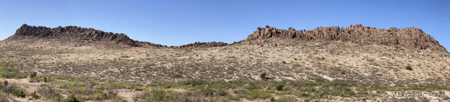
The trail continued west, climbing up along the Coyote Hills, making this part of the day quite scenic. The hills were capped with rock that looked like a spine or backbone.
In the Coyote Hills, I passed by a large tree with shade. There was even a makeshift bench made of a couple of planks of wood sitting on a tire. It was quite tempting, but I wanted to keep moving.
The trail bounced up and down for a bit, until reaching a saddle, with a nice view. After passing over the saddle, I generally headed downhill. I stopped for a short break at a campsite not far from the saddle and contemplated stopping there. I’d already gone over 20 miles at that point, and I would have had a great view of the sunset, but if I could make it another three miles down to the water cache, that would take three miles off tomorrow’s hike. Plus, it was only an hour and a half from sunset, and it was noticeably starting to cool off. Any mileage I did now would be far more comfortable than whatever I’d have to do in the heat of day tomorrow.
Because of how I’d been carrying my extra water, my pack was a bit unbalanced, and I think it was making it feel heavier than it should have been, so I attempted to transfer water from a foldable bottle (which was causing the imbalance) to my rigid water bottle, and in the process, dropped the foldable bottle and wound up accidentally spilling over a liter and a half of water before I could pick it up. Having done that, it was settled; I couldn’t stay where I was, because I now probably didn’t have enough water to camp away from a water source.
So, I sped downhill as quickly as I could, chasing the last rays of sunlight. As the sun descended, shadows lengthened, making it harder to discern complicated shapes, like campsites besides the trail.
Or simple shapes, like branches. Maybe ten feet ahead of me (though quite possibly less), I saw a very unusual-looking branch. “That’s a very unusual-looking branch”, I thought to myself, as the “branch” coiled up and started rattling at me.
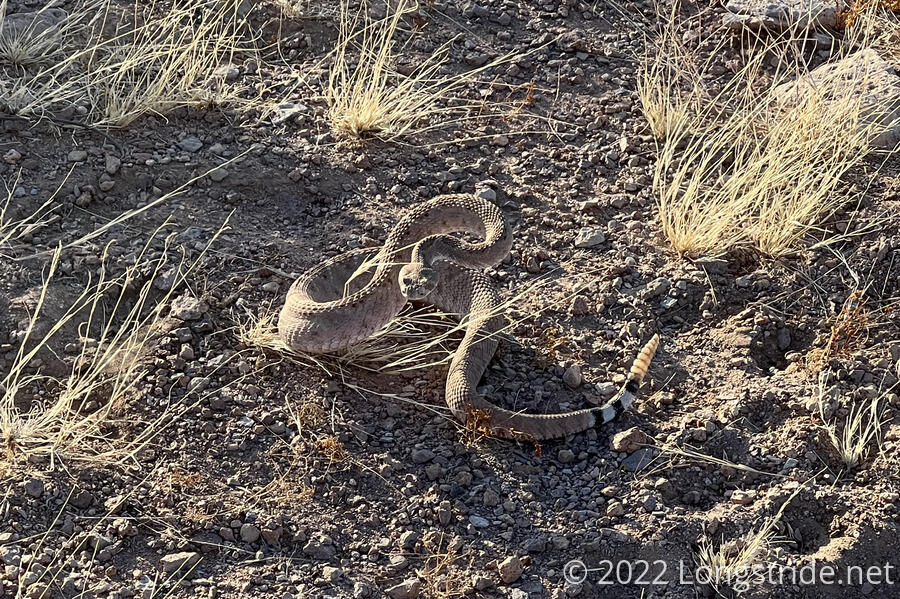
Fortunately, the rattlesnake wanted to have about as much to do with me as me with it, and I slowly backed off and circled around it.
I made it to camp, at the fourth of the CDTC water caches, about nine minutes after sunset, hiking 25.5 miles. Certainly not a distance I’d expected to do on my third day on trail. Fortunately, this means tomorrow’s hike will be just under 20 miles to the next water cache. I rather quickly got my tent set up, and tried to get to sleep “early”. I’m setting a 5 am alarm so I can actually leave camp before sunrise tomorrow.