Today, I returned to the Patapsco Valley State Park for a fourth time to hike in its Woodstock Area, with MAHG. Today’s hike was a scouting hike: thirteen of us met to scout out a trail route that would hopefully become part of MAHG’s staple of hikes.
We met at a parking area across from the Woodstock Inn, and set off to the east, into the woods, generally following the active CSX railroad line that largely parallels the Patapsco River. As we got started, a west-bound train clacked and screeched loudly through, its first several cars seemingly filled to the brim with garbage.
Over the next mile and a quarter, the trail, a narrow, damp, muddy mess, weaved towards and away from the railroad tracks, and bobbed up and down a few hills before crossing the Davis Branch, a small tributary. After a short uphill climb, the trail doubled back, re-crossed the branch shortly upstream, and followed the course of the stream a short distance away and uphill, in the general direction we came from.
Over the course of a mile, the trail gradually climbed a 200 ft hill, again bobbing up and down as it vaguely followed the park’s perimeter. This section of the park has quite a few intersecting trails, and we stopped frequently to consult maps to determine exactly which way we needed to turn. Occasionally, we’d tie a ribbon on a tree to mark the direction we selected, to identify the route for a follow-up hike or to assist if we decided we made a wrong turn.
This section of park is also adjacent to several housing developments, up on a steep hill from where we were hiking. I mused that they probably visited the park frequently, though it’d be nicer if they didn’t have steep hills separating them from the hiking trails. Almost as soon as I verbalized that thought, we came across a not-too-steep dirt access road that had clearly been recently used. Judging from its general direction, it probably led up to the houses. We followed it down, though, towards the river and railroad tracks.
The dirt road would have taken us all the way to the railroad, but we turned off of it just before, heading up a hill that took us south, away from the river. The top of the hill gave us a reasonable vantage point of the train tracks, and we saw an SUV parked along the tracks; this was probably the vehicle that made the tire tracks in the access road we had just followed.
Again bouncing up and down a hill, we weaved along its side, the trail loosely following a stream until it was far enough upstream to cross over, before looping back north, following the stream (and crossing twice more) back towards the railroad and the river.
This whole section of the trail led itself very well for a winter scouting hike. In several places, we could clearly see the overall shape of the terrain, and several other trails a distance off. Come spring and summer, when the trees are full of leaves, we’d lose that ability.
As we approached the train tracks, we saw two trucks parked on one set of tracks; a work crew was there installing a new electrical line for a switch that joined two tracks west of there with the single track heading east. A second train also picked that time to clack and screech through, so we paused for a few minutes to let it pass.
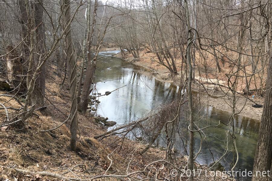
We briefly followed and crossed the railroad tracks, now following the river more closely, along an the old railroad bed. (The railroad had long since been moved to its present location, slightly more uphill and through a tunnel.)
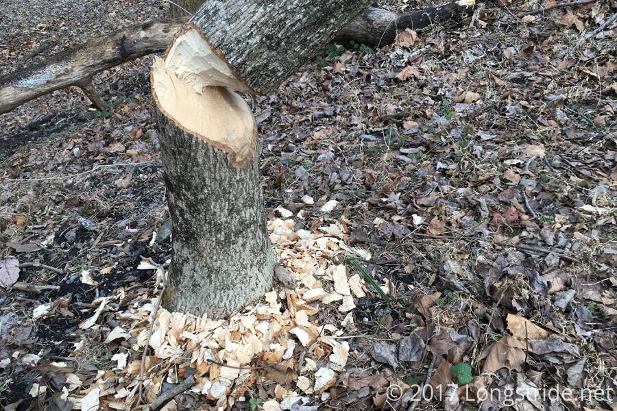
The trail led us in a semicircle, going around the hill that the railroad currently tunnels through. Following the river, the work of beavers was quite evident; several small trees had been chewed on and felled.
That brought us to the end of the “out” portion of our scouting hike. The original plan had been to check out the railroad bridge across the Patapsco and then head back the way we came, perhaps finding an alternate loop back so it wouldn’t be simply an out-and-back hike. But at this point, it had already been five miles, out of a planned seven; going back the way we came would likely put us far over our planned distance.
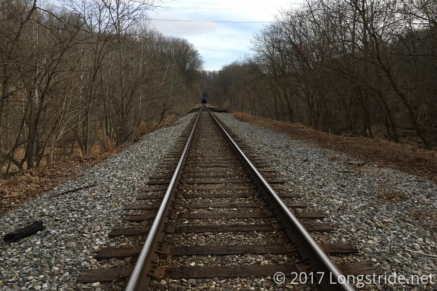
I’ve said before, “What's a hike if it doesn’t include a little bit of adventure?” We took that to heart here, too, and crossed the railroad bridge.
Since I’m here writing about it, you can assume the bridge crossing went without incident. It was still rather sketchy to cross, though. The wooden ties were awkwardly spaced for walking, slightly spongy, most had pieces chipped off, and a few were even missing! The bridge was also a bit longer than it initially seemed (I think just because crossing it was slower than I expected). I’d not recommend crossing that bridge. But, all of us made it in one piece.
We followed a very steep embankment down from the tracks, a set of tall concrete stairs paralleling a steep gravel slope, providing a slightly easier option of getting down off the artificial hill built up for the train tracks.
From there, a trail picked up, following the tracks a bit before turning back on itself as it climbed a hill towards a set of power lines that crossed the river the same place as the train tracks.
Reaching the clearing for the power lines, we found a mailbox. Whether there as a joke, or if it had an actual use was a question that would not be answered today. We crossed the clearing, headed down a steep hill, and crossed one last stream.
From here, the trail headed due west, back towards our starting point. Though there were a few small hills here and there, the trail largely followed the river, and gradually gained two dozen feet of elevation over two miles. I was not terribly surprised when a third train rumbled along the tracks
Following the river, the trail joined with the Patapsco “Thru” Trail (which does not actually run the length of the park), crossing under the bridge for Woodstock Road. The trail looped back uphill, ending at the road, and we completed our hike with a short roadwalk back to our cars.
All in all, this was a great hike. The early day was a bit muddy and slick from recent rain, but with the absence of leaves, provided nice views of the contours of the park and a fun bit of hilly terrain: some hills, but still, fairly easy. The sketchy railroad bridge wasn't much fun, and the backside of the hike had some relatively boring terrain, but there were still nice views of the river.
A second scouting hike is planned, maybe in a few weeks, to find a route back from the railroad bridge that makes the hike not simply an out-and-back path. There’s enough trails in that section that we didn’t hike on, so there’s probably a way to do it!
Next up: a hike in Shenandoah with the PATC!