Our second day on the East Coast Trail took us through more challenging terrain, but also gave us some great views as we proceeded north along Newfoundland’s coast.
A 6 am alarm got CareFree and I hiking at 8 am. Yesterday’s’ overcast weather had become a fog, with the clouds kissing the treetops. It was a little warmer than I’d been anticipating, though; still a little cool when not moving, but it was perfectly fine while hiking.
We didn’t have any views at all for about the first two and a half hours of today’s hike, thanks to the clouds, which made the morning a bit more rough that it might otherwise have been. The more difficult ground than yesterday slowed us a little, and despite getting in some strenuous hiking last week to help prepare, my efforts throughout the day felt amateurish compared to what I feel I’m usually capable of.
At least, despite the clouds, the ground was dry, so we didn’t have slippery mud or rocks to worry about.
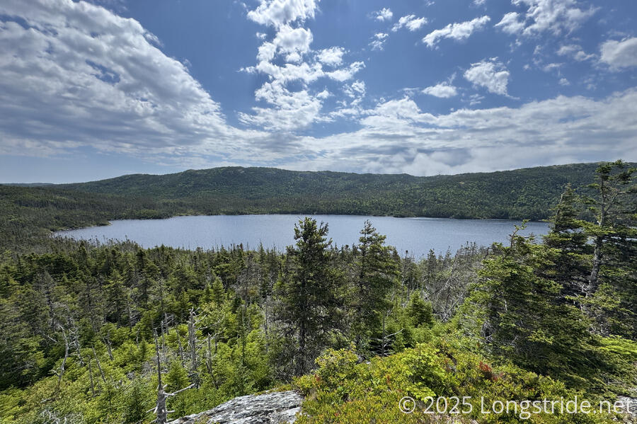
Once the fog started to lift, we continued to get nice views of the surrounding ocean and coves, and Bell Island continued to appear, through gradually receding into the distance as we continued north.

After two and a half hours, we passed the campsite we were originally aiming for yesterday. Had we continued hiking there yesterday, we wouldn’t have arrived until well after sunset, so stopping “early” yesterday (still after 7 pm) was a good idea.
For a while, it was pretty clear out, with the sun harshly bearing down on us, though the wind, especially in exposed areas, kept it somewhat cool. Later in the afternoon, clouds returned, though it was still fairly bright out.
The most difficult portion of the Piccos Ridge Path was towards its north end, with a few very steep ascents and descents, assisted by ropes. In most cases, the ropes weren’t necessary for us since we have trekking poles, but they were still quite useful to have, especially in wet weather. Part of this section of trail was badly deteriorated and eroding, and I wouldn’t have wanted to be hiking there when the ropes were actually necessary.
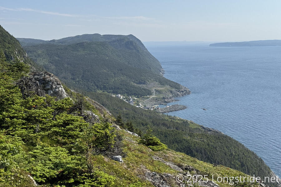
The Piccos Ridge Path was very rugged, slow, and frustrating. But we kept moving forward steadily and finally made it to the end shortly before 3 pm, taking seven hours to go roughly 14 km (including breaks). We stopped at a grassy picnic area above the town of Bauline.
Overall, the trail felt like it was routed with lots of pointless ups and downs, but at least it was very scenic when we did have views.
Our major issue was that we were low on water. Water had been somewhat scarce on the Piccos Ridge Path, and didn’t look to be in good supply on the upcoming White Horse Path, which continues along the cliffs north of Bauline. On the community walk from trailhead to trailhead, we passed a resident and asked her if there was somewhere in town we could get water; she offered to give us water at her house. A short walk later, we were completely filled up (with cold water!), which was really good because my pack bladder was almost completely empty, and the hike to the next water source on-trail would have been very uncomfortable.
As we arrived at the other end of town, a woman living in a house next to the trailhead offered us water as well. We chatted for a few minutes. She said that Piccos Ridge was the hardest path on the trail, so fortunately, we have that behind us now. She also said we should be able to see whales from the trail, which we were hoping for.
Not a minute after we continued up the hill, we saw a pair of whale spouts from a small viewpoint. The next hour or so was very slow to hike, not so much because the trail was difficult (though it was, and also windy), but because we kept stopping to look at the whales. They were far enough offshore that we didn’t get really good looks at them, but at one point, we could see six whale spouts at once. (We would have stayed longer there to watch, but it was incredibly windy, and starting to get actually cold.)
The whales were hard to photograph, since they were fairly far away and didn’t stay on the surface for very long, but we did get some nice views back to Piccos Ridge and Bauline.
While the White Horse Path was definitely a bit easier than Piccos Ridge, much of the challenge of this stretch came from it being rather overgrown. It’s always slower to walk when you can’t see your feet and you’re constantly pushing through pine trees crowding in on a narrow path.
With hiking on White Horse being nearly as slow as on Piccos Ridge, we also didn’t see ourselves making it to the campsite we’d planned on (already short of our goal, since we were behind from yesterday), and started looking for early options. We passed a dry creek (the not-flowing outflow from a lake) and the campsite that was supposed to be on the hill nearby that we didn’t see, making me a little resigned to having to hike to the next known campsite, likely putting us there near sunset.
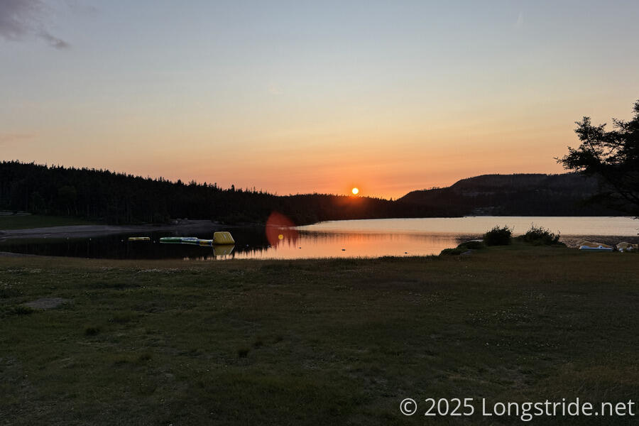
A bit frustrated, we stopped at an observation area just off the trail at the end of a gravel road, with a pair of binoculars and a small playground. CareFree wanted to just set up the tent in the corner of the area out of the way. I didn’t think this was such a good idea, and called the office for Marine Park, an RV “campground” that owned the area, and asked if we could camp there. They said no, because people often go there to watch the sunset, but after hearing we had been hiking since 8 am from near the start of Piccos Ridge, they offered that, while they can’t usually do this, we could stay at a reduced rate at one of the few of their RV sites that actually had grass we could pitch our tent at.
The manager, Bruce, then went out of his way to pick us up as we were walking to the campground office, and he gave us a little tour with his four-seater golf cart, showing us the site we’d stay at, where the lakefront beach was, where the rest rooms were, and where the camp store was. We got some extra food (soda, ice cream, candy, and a microwaveable cheeseburger for me — because why not?), and Bruce drove us to our campsite, in a somewhat secluded area with five other sites, two of which were occupied.
What we saw walking from the trail, and learned from Bruce, is that the campground really is geared specifically to long-term site rentals (they have very few overnight spots, and no backpacker sites). And everything is pretty spread out, so even from our site, it was a relatively long walk to the bathroom near the beach — not a concern for most campers because their RVs have toilets.
Shortly past the dry creek we passed earlier, we could see a large flat clearing on the nearby mountainside. We initially assumed it was a parking lot. In talking with Bruce (and also seeing No Entry signs for construction work along the road to the campground), we realized that they were actually part of the park’s expansion plans.
After setting up our tent, we ate dinner at a small covered picnic table in a sort of common area for the six sites in our area. We didn’t see either of them show up, though. (Bruce said most people are here on the weekends.)
Our schedule for the next couple of days is looking constrained. We planned to hike 47 km yesterday and today, but only managed 37, which puts on pressure for getting to St. John’s in three days, because we have a room booked there already. Worst case, we can get an uber to town from a road crossing along the way, but that’s not really what we’re out here to do…