It was a little bit cold in the morning, but the sun was shining, and a clear blue sky was overhead. This had the makings of another excellent day of hiking. My original plan for the day was to make it to the Battell Shelter, the next shelter north on the trail, but the unexpected distance covered yesterday opened up other possibilities: one of the three shelters only a few miles from Appalachian Gap, VT 17, the road to Waitsfield, my next resupply stop.
As usual, Zippy zipped up her pack and left first (the origin of her trail name), followed by me, and shortly after, Goldfish and Fresh Pot. Our destination was unclear, except that it was somewhere north of where we started.
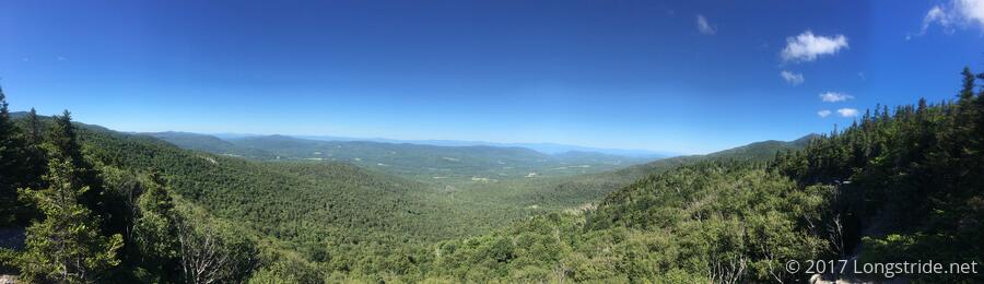
The day started with the ascent and summit of Mount Grant, which featured some climbs up rock slabs, providing a decent view of the landscape behind. But the first real scenic view of the day was at Sunset Ledge, a west-facing rock outcrop with an expansive view of New York's Adirondack Mountains to the west. I found Zippy already there, reading a book, and, since this seemed a good place for a break, I grabbed a snack, sat down, and took in the scenery.
Goldfish and Fresh Pot arrived shortly thereafter, and the four of us spent altogether too long on the ledge, taking in the view and considering plans for where to end the day. While we were basking in the sun, my pack, boots, and socks got a thorough drying out, and when it was finally time to leave, it was a really good feeling to put on toasty warm socks and a dry pack.
I led the pack down the mountain into Lincoln Gap, and then up to our next stop, Lincoln Mountain's Mt. Abraham, which has 360 degree views of the surrounding landscape. To the south, was Killington, where I had been 6 days and 60 miles ago. To the west was the Adirondacks. To the east, The Whites, with Mt. Washington visible in the haze. To the north, our destination in a few days, Camel's Hump.
Upon arrival, we were greeted by a GMC caretaker, who gave each of us a peppermint patty. The topic of food came up: Zippy was apparently low on food, and there was a bit of continuation from a conversation yesterday, when the question was posed, "if you could have only five foods, what would they be?"; my answer of "pizza, with pineapple, sausage, and green peppers" (which was intended to be one of five) then forced the question, what exactly is a "food"? The summit was fairly crowded with day hikers (and several dogs, including a photogenic corgi), and they couldn't help to overhear us talking about food, so we found ourselves in the position of having unintentionally "Yogi"ed for food: from different people, we were given a banana, a nectarine, and grapes.
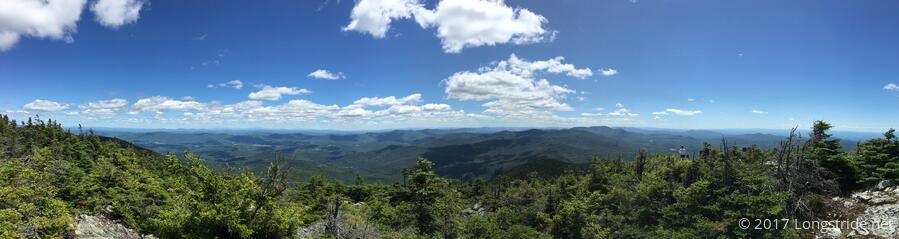
After baking in the sun for far too long, Goldfish, Fresh Pot, and I continued on, while Zippy continued to take in the view. (We had been on the summit somewhat longer than she was, as she was apparently delayed by a stick in her boot, and then hiked slower than the rest of us.) The trail largely followed the ridge on Lincoln Mountain, bouncing up and down a bit for four more peaks before beginning the descent down the north face of the mountain. The three of us made a brief stop at a closed ski lodge along the way, where another pair of day hikers gave us each a handful of cherries. They were delicious, and their water content was very much appreciated, as we found ourselves all unexpectedly low on water. (Baking on two exposed rock faces for probably nearly two hours did not do wonders for our hydration.)
From the ski lodge, I again led the pack (if you can call three hikers a pack), attempting particularly to keep a steady, not-too-fast pace in order to conserve the little water we had left. We ran completely out of water at an overlook almost immediately before the turn-off to Glen Ellen Lodge. While there was supposed to be water at the next "shelter", the Stark's Nest Warming Hut, on or fairly close to the trail, we decided to take the 0.3 mile side trail to Glen Ellen Lodge so that we could get water now. This was a wise choice, I think.
After collecting slightly greenish water from a small waterfall shortly before the shelter (and which was still slightly greenish even after filtering), we sat down in front of the shelter for a short break. I decided that, as it had already been a good 13 mile day, I was going to stop here so my feet did not murder me on the way to the road, 3.4 miles ahead. Goldfish called to reserve a room, and he and his wife pushed on to go into town.
My trail legs appear to be making a comeback, though the callouses on my feet essential for high mileage days are lagging behind. Goldfish twice commented on my pace, noting that he and his wife often "gas out" — they go too fast initially, then run out of energy to keep going long distances — and credited my pace with them being able to consider hiking the rest of the way into town. (I knew I could make it to town as well, but I also knew my feet would be very unhappy if I tried.)
Us being the only people at Glen Ellen Lodge, and it being after 5:30 when they left, I predicted I'd likely have the shelter to myself: more than likely, anyone still hiking on the mountain would go to one of the two shelters closer to the road, or even go all the way to the road and hitch into town. And now, several hours later, my prediction is confirmed; I have the shelter to myself. This is only the second time on the trail that this has happened. (The first was at Kirkridge Shelter in Pennsylvania on the AT last year.)
In the shelter was a note from Bill, Chuck, and Todd, to Pete and Jen, dated July 22 (8 days ago), with a beer (Brickstone Hop Skip). I guess Pete and Jen never made it to the shelter to pick up their beer; I wonder how long it'll stay here before someone else drinks it.
Glen Ellen Lodge has the most expansive view of the sky I've seen, and the forecast is for clear skies tonight. If it were a bit warmer, I could really use Gas's camp chair for a bit of stargazing.
Tomorrow: The plan is a short day into town, with resupply, and relaxation, but I am also reconsidering the plan for the next few days. Originally, I expected to hike 16 miles the day out of Waitsfield, climbing up and over both Mt. Ethan Allen and Camel's Hump. Given the elevation profile, this now seems a bad idea.