A long and varied day of road walks, farm trails, and the Tahuanui Track through the Pirongia Forest led us to our highest point yet in New Zealand.
With a longish day ahead, we left the cafe in Whatawhata a little before 7:30, continuing the road walk we started yesterday evening. As is typical for New Zealand, it was humid out; there was a little fog at our campsite this morning, and the mountains ahead were cloud-capped.
We began the day with a slight detour, sticking on the road rather than following a trail down to a river. Comments in our trail guide suggested it was a wet, trashy section with bad markers. Also with the fog, the ground was wet, and if the trail is overgrown (because of course it would be), we would quickly have wet feet.
We passed by a farm with a bunch of cows near the road. CareFree mooed at the cows, just for fun, and one of the cows, probably a bull, started replying in deep, threatening moos as we passed. It was probably a good thing there was a fence and a stand of trees between the cows and us.
A little later, we heard, and then eventually saw, a helicopter flying relatively low over the farmland adjacent to the road. It had some sort of boom sticking out to the sides. I suspect they were spraying the fields with something; they also appeared to adjust course when we were walking nearby.
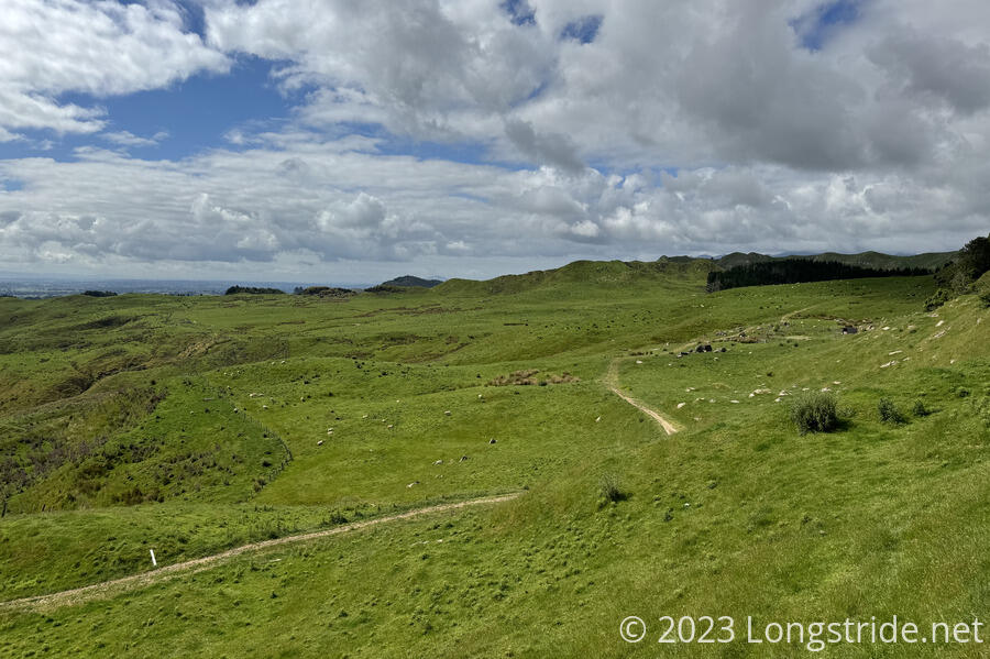
The paved road gave way to gravel, as we began a climb up towards farmland. As typical, we followed a steep fence line for awhile. Then, the trail cut through the hillside, a lush green meadow for sheep grazing that had some different rock formations to what we’ve seen elsewhere.

We passed quite a few sheep on our way through the farm, as we crossed a few stiles (or went through adjacent gates instead).
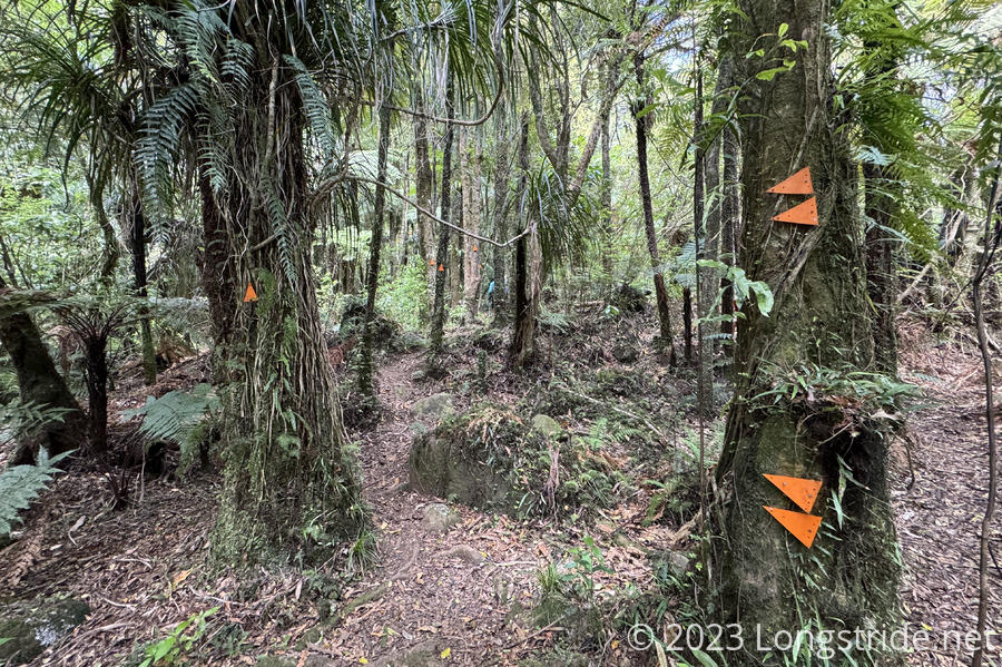
The trail through the farm eventually brought us to a forest that took us downhill. The trail in the forest was generally pretty great, though occasionally a little steep. On our way down, we passed two TA hikers, one of whom had a seemingly gigantic pack.
After exiting the forest and wandering around some more farmland, we reached a car park, and stopped for a break.
We chatted with the two hikers when they caught up with us. Jackie, from Australia, decided to hike the TA. Her friend, Jess, also from Australia, decided to join in. Somewhat similar to myself, Jess has embraced a travel lifestyle, running her fully-remote digital design company from wherever she happens to be.
From the car parking lot, we followed a road for another half hour, meandering up a ridge with views of farmland. We then left the road, following a very nice, shaded trail along a creek for another half hour to the Kaniwhaniwha Campsite. This is where we’d originally planned on ending the day. But, since we’d pushed to Whatawhata yesterday, it was still early in the afternoon, so we had plenty of time to hike up to Pirongia Summit, the high point of the Pirongia Forest we were now in. Signs indicated that’d take another 4.5 hours.
It was pretty hot out, and we were running low on water, so we took an early, long break at a picnic table to get water from the creek we’d been following and filter it. We also took the opportunity to dry out our tent’s rainfly, which was pretty wet when we packed it up this morning.
Signs pointed to two ways up the mountain: the Bell Track, which was estimated to take 9.5 hours, and the more direct 4.5-hour Tahuanui Track, which goes straight up a ridge from the campsite.
Leaving the campsite, we reentered the forest, navigated a couple of annoying stream crossings, and then began a steep ascent up the ridge towards the summit. The trail was fairly-well maintained, though, making it not overly difficult, aside its steepness. There was some mud to deal with, but overall, it was mostly dry, and enjoyable.
I kept a good pace for a while, but after about two hours, I ran out of stream and slowly trudged the rest of the way up. I should have stopped for a snack break, but CareFree had zoomed on ahead, so stopping would only have put me much further behind.
I finally caught up at a viewpoint to the west overlooking farmland far below, had a snack, and rested for a bit. But not very long, since we were still a kilometer from the summit.
Still tired, and now slowed by a very steep and muddy trail, it took me another 40 minutes to get up to the Pirongia Summit. At the top was a viewing platform, giving a 360° view. To the east, we could again see the ocean, the Tasman Sea. But, we couldn’t stay long — it had gotten cool, and windy.
At 959 m, Pirongia is now the highest point in New Zealand we’ve been to so far.
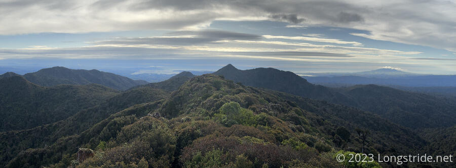
The mud up to the summit was bad, and then interrupted by a surprise — and very welcome — boardwalk to the view, and a bit after. But then the boardwalk disappeared, and the mud got considerably worse. This is probably a harbinger of tomorrow’s descent down the mountain.
The 4.5 hour estimate to the summit was reasonably accurate; it really did take us about 4.5 hours to get from the campsite to Pāhautea Hut.
This is my first visit to a DOC hut, and it was much nicer than I expected. On the way in, I passed by several campsites (mostly full!) and a shelter for use by campers for cooking. The hut has a large common room with three large tables and benches, sinks (with collected but untreated water) and space to cook, and two bunk rooms with 20 spaces in total, with nice mattresses. The outside of the hut had a large wraparound deck. A short distance away, three toilets and a foot-washing station rounded out the amenities.
In the hut were two families, and a group of hikers who were camping but hanging out in the hut’s common room. The Scottish couple we met the other day arrived later.
By the time we got settled, got and filtered water, and started dinner, it was nearly 8 pm, and we were pretty tired.
My feet hurt. Today was easily the longest, steepest climb, with the most elevation gain we’d done so far this trail, and my feet were justifiably frustrated. But it was a good day, with great views. And quite varied, too. As CareFree and I were going through the pictures from today, this morning’s farmland felt so long ago that it didn’t even feel like today.