A long day today took us from Ngāruawāhia, through Hamilton, and on to Whatawhata, and set us up for a summit of Pirongia Mountain tomorrow.
The first half of the trail today was along the Te Awa River Ride, a 65 km cycle path from Ngāruawāhia to Lake Karapiro, via Hamilton, along the Waikato River. This gave us a nice, easy track for the first half of the day.
As we left Ngāruawāhia, we passed a number of informational signs, describing the cycle path and its creation, local plants and animals, and some Māori culture.
From its start, the cycle path followed the Waikato, often from a cliff above the river. The hard concrete path wasn’t very friendly for our feet, but it was fairly flat, and we did make good time.

Along the way, we met Scottish couple Kirsty and Craig. They said we were the first TA hikers they’ve seen in a week. (At first I didn’t think this was too far off from our experience, but I think we’ve actually seen at least eight other TA hikers since we left Auckland besides them, so they may well have just been unlucky.)
The cycle path was quick to walk, but as we got further from Ngāruawāhia, it started to get less interesting. The path veered away from the river for a bit, but when it got closer, potential views were often blocked by trees. Houses sprung up on both sides of the river, occasionally perched on a tall cliff overlooking the river. As we got closer to Hamilton, it wasn’t a very enjoyable path to hike. But, as a means of transportation between communities along the river, the path it was quite utilitarian, and we were regularly passed by cyclists.
After 20 km, we stopped for a break (our second) at a bench overlooking the river. We had a simple plan: finish going into town (just over 1 km) and go to an iSite, so CareFree could purchase some single-use DOC hut passes for the Tararua Range (since she doesn’t need a six-month pass like I got when in Auckland), then go to a McDonald’s for lunch, and head west out of town, stopping at Countdown to resupply for the next stretch to Te Kūiti.
We also arranged to meet up with Hannah at the iSite. Although we hadn’t seen her since Kaitaia, we’d still been in regular contact. With a combination of skipping lousy sections and several long days, she’d passed us, and had made it to Hamilton a day ahead of us. After a bit of consternation trying to work out the logistics to go on a tour of the Hobbiton Movie Set tomorrow, she managed to make it all work out, and was quite happy about it.
After a bit of a runaround because the iSite wasn’t where our trail guide said it was, we met up with Hannah. CareFree got her hut tickets, and the three of us went off in search of the McDonald’s. We couldn’t find it; I suspect it was inside a shopping mall. But, we saw a Burger King, and went there instead. The burgers were great, though we were saddened by their lack of milkshakes.
We had a lovely conversation with Hannah, but alas, we still had another 15 km to walk to resupply and make it to Whatawhata, so we bid farewell, and continued on.
Central Hamilton felt a bit more gritty than Auckland did. Being a much smaller city, it’s not surprising that there was a much quicker transition from ritzy cliff-top homes, to central city grit, to farm houses. What took us easily four days around Auckland took less than a day with Hamilton.
Our resupply and repacking at the Countdown took less than an hour. All things considered, I think this might have been one of our most efficient town resupply stops ever, on any trail. Not staying in town easily accelerated us by a day.
In Auckland, CareFree bought a new pair of shoes. She carried them 150 km to Hamilton, rather than wearing them, to avoid “wasting” the tread on the significant amount of road walking between the two cities. She finally disposed of her old shoes at the Countdown, having me unceremoniously drop them into a garbage can with the rest of the discarded packaging from our resupply.
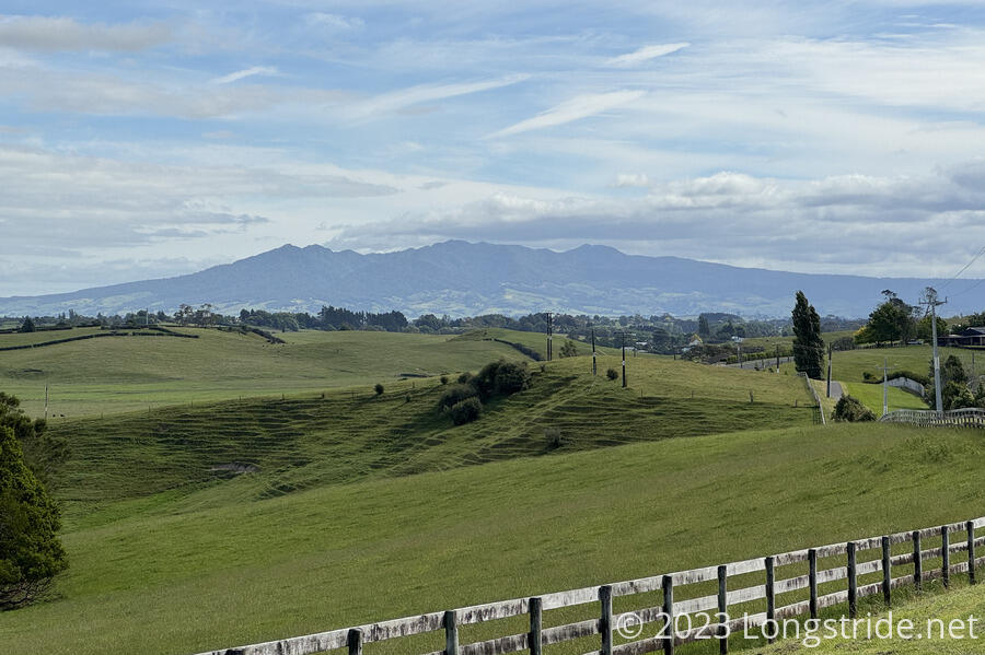
Leaving the Countdown, we made our way out of town via a cycle path that climbed up a hill to a small viewpoint. In the distance, we could see Pirongia, which we’ll summit tomorrow.
A sign on a pole largely hidden by brush claimed that we were 800 km from Cape Reinga, with 2200 km left to go to Bluff. (At that point, we were really closer to 780 km in; the discrepancy is easily accounted for by the significant trail relocations due to forest closures in the north.)
The whole area around Hamilton appears to be horse country. Especially on our way out of town, but also a bit this morning after we left Ngāruawāhia, we saw quite a few horse stables, and signs for horseback riding lessons. We may even have seen a horse show getting set up this morning, though we didn’t take the time to investigate.
Now outside of Hamilton proper, we followed a gravel trail on the outskirts of the Taitua Arboretum, and then crossed a farm, following a fence line up and down steep hills.
Some more road walking brought us to Whatawhata. We knew the cafe we were camping behind would be closed, but we saw a gas station on our way into town, and had hopes for soda and ice cream. Alas, they also were closed. We probably could have gotten something from the bar across the street, which was definitely open, given the loud live music coming out of its doors.
We set up our tent quickly, joining easily another ten hikers who were already there.
In the evening, we revised our plan for tomorrow. Although we’d come to Whatawhata to give us a shorter day to the campsite at the base of Pirongia Mountain tomorrow, we instead decided to continue to be aggressive, and push to the top of the mountain and stay at the DOC hut just beyond the summit. It would make tomorrow longer than we’d initially planned, with a steep climb to finish the day, but it would also break up the climb to the top (which is not supposed to be otherwise difficult) and a very muddy descent afterwards. (Also, there’s limited camping options after, so a shorter day coming down would be beneficial.)
We tried to book space for the hut, but it was full, so settled for a campsite (the last available, as it turned out). Later, I checked again and found the hut had two spaces open up, so we quickly grabbed those instead.
At 35.9 km, today was our longest day so far. It’s exciting to see our pace gradually accelerate as we work our way through the North Island.