It was awfully windy and cold last night (at least, not as cold as it was in the Smokies, though), the wind whipping my tent and even making it into the tent by blowing under the rain fly, but my sleeping bag kept me nice and warm and toasty overnight.
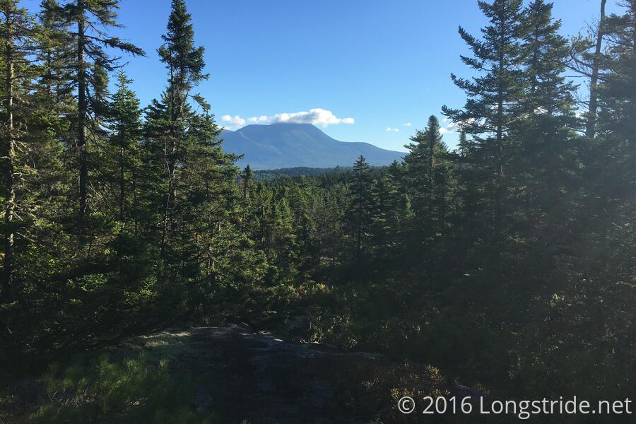
I got up early, and managed to leave the campsite shortly after 6. The terrain was almost flat, up until the climb up to the Rainbow Ledges, and even that wasn’t too bad. The ledges provided a clear view to Katahdin, the summit hiding behind a cloud. I took a break there, hoping the cloud would pass, but it didn’t.
A gradual climb down Rainbow Mountain brought me to the Hurd Brook Lean-to, the last before The Birches at the base of Katahdin. From there, the trail was a little bumpy, but it leveled out as it approached Golden Rd.
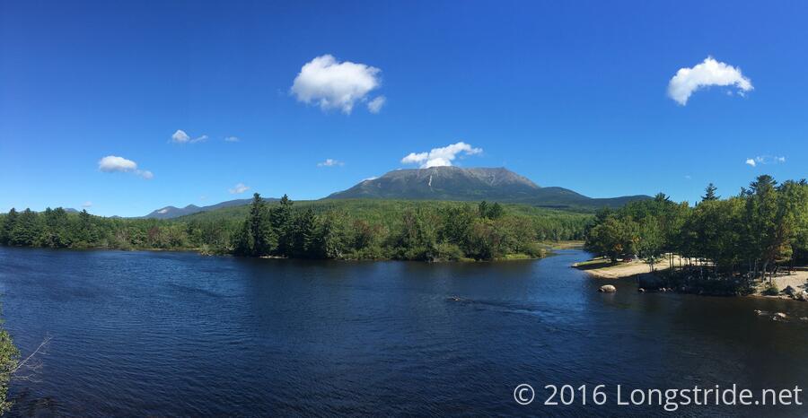
At 10:45, I reached Golden Rd, and the sign marking the end of the Hundred Mile Wilderness. Just ahead lay Abol Bridge, crossing the wide west branch of the Penobscot River. Just over the bridge is a convenience store and restaurant. Lacking electricity, the convenience store and restaurant are both relatively expensive, but it was worth stopping there for a cheeseburger.
Mothly Stud and several other hikers were there ahead of me, waiting for the restaurant to open (at 11), as was a park ranger from Baxter State Park. The ranger was there to help coordinate arriving hikers by keeping track of who was coming in, and where they were planning on staying.
There are two conveniently located places to stay at the base of Katahdin: The Birches (available only to thru-hikers), and the shelters at the Katahdin Stream Campground. I had discounted the KSC since getting a space there generally requires advance (and non-refundable) reservations, and they were already all reserved. However, thanks to the ranger, I learned that another group of hikers in the restaurant had gotten two of the shelters at the KSC, and had space available in one of them. I asked, and they agreed to let me stay in their shelter, so that also conveniently freed up a spot at The Birches. (And, it’d cost me slightly less.)
Begrudgingly, I paid for an hour of wifi access at the convenience store. I let Mothly Stud borrow my phone for a bit so he could coordinate with his girlfriend, who was meeting him tomorrow to hike Katahdin.
I finally left the restaurant sometime after noon, and after a short walk down Golden Rd, I entered Baxter State Park. For the next while, the trail followed the north side of the Penobscot along basically flat terrain, and I maintained over a 3 mph pace for just under an hour, before I stopped to take a break to rest my feet.
The trail turned, and started a gradual uphill at the Nesowadnehunk Stream, and after fording it twice, the first of which was a bit tricky (mostly because I didn’t want to stop to take my shoes off, and I wound up nearly slipping as I made it across, dipping my shoe into the water, but not far enough in to get my feet wet), I stopped for another break and to get more water.
While I was filtering water, Mothly Stud caught up (and collected water himself), and the ranger from earlier came by, to do some trail maintenance further ahead.
I made it to the Katahdin Stream Campground shortly after 5, and signed in at the ranger station. This is the first year that Baxter is requiring permits for AT hikers to hike Katahdin; according to their register, I’m NOBO #655.
I went over to KSC lean-to #8, where my shelter-mates were waiting: thru-hikers Sea Dog, and Pepper and Salt, a German couple.
At the parking lot adjacent to the KSC, a hiker’s family was providing trail magic. It being late, they didn’t have much left, but I was able to get a sandwich and some orange juice.
Back at the shelter, I made my usual dinner, and the several of us chatted, also joined by Shiv and T3. Apparently, the squirrels around the KSC are vicious, and when they left their packs and food bags unattended for just a short while, the squirrels chewed at them, managing to get a peanut butter sandwich or two.
We all went to sleep relatively early, having decided that 7 am tomorrow would be a great time to start our last day on the AT. From here, Baxter Peak is only 5.2 miles away.
It won’t be long now...