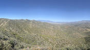
Yesterday was a bleak landscape of cactus, rocks, and dirt. Today was anything but. As I said the other day: turn the corner, and you’re in a completely different painting.
read more (1184 words, 4 photos)
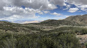
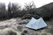
With my tent properly set up, and a distinct lack of wind, I slept reasonably well last night. I was so tired from the long day, though, that I slept in a bit and didn’t leave camp until almost 8:45 am. And that late start was further delayed by an unexpected surprise: a water cache just a few tenths of a mile from where we camped, and earlier than the expected one under the CA-78 bridge at Scissors Crossing.
read more (965 words, 3 photos)
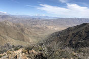
Last night was one of my most uncomfortable nights on the trail ever. I’m not entirely sure I actually got any sleep, as the continuous winds caused my tent to flap incessantly. It was very loud, and I couldn’t even stretch out comfortably because then the tent’s flapping around would cause it to hit my feet and head. Somehow, I managed at least a little rest, and around 5 am, the winds started to die down and I could “sleep” a little more comfortably.
read more (968 words, 2 photos)
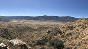
The word of the day is windy. Almost as soon as I left the Mount Laguna Lodge, the wind started, and it rarely let up all day. There were also a number of incredible views, often of the desert just to the east.
read more (509 words, 3 photos)
Today was a short day, but ultimately necessarily so, thanks to last night’s unexpected cold. I should have checked the weather report sometime yesterday. It was already somewhat cool when I got into my sleeping bag, and the temperature continued to fall throughout the night. In retrospect, I should have just stayed in my hiking clothes, rather than putting on my camp clothes, if for no other reason than my hiking pants have (detachable) long legs, and my camp shorts don’t.
read more (1106 words, 3 photos)