Today was a long day, mostly on road on the way to Grants, with an interesting but strenuous detour.
With the Cebolla Alternate for the rest of the day being a roadwalk, most of which would be paved, Dog Bite, Plus One, and Mr. Freeze got a bit of an earlier start, wanting to get more done in the lack of shade before the sun got hot. As Dog Bite was leaving, this gem of a conversation happened:
Dog Bite: We’ll meet at the well, yeah?
Simple: Hey, when you get there, think you can pour some of those flavor packets into the well so that when it comes out it’s already flavored?
Dog Bite: Yeah, how many you think I need, like 50?
Simple: Sounds right.
Simple, Patches, and I started hiking around 7:30, heading north out of the canyon we were in. It didn’t take long before the sun rose over the mountains, and it started to get warm pretty quickly.
After half an hour, we reached a Y-intersection with a sign indicating that we had just come from Sand Canyon. That certainly explained the amount of sand on the road to that point.
After a couple of miles, we turned off trail to go to an old windmill that had been retrofitted with a solar panel. I thought this was the meeting point Dog Bite mentioned, but, it wasn’t. I opted not to get water here, rather getting it from the next well. But, when I followed the path that was supposed to go back to the trail, I couldn’t actually find the road that my map said I was supposed to follow. I instead followed another dirt road that was on my map, which was a little longer, but still got me to the next major intersection, NM 117, the paved road I’ll be following for most of the rest of the way into Grants.
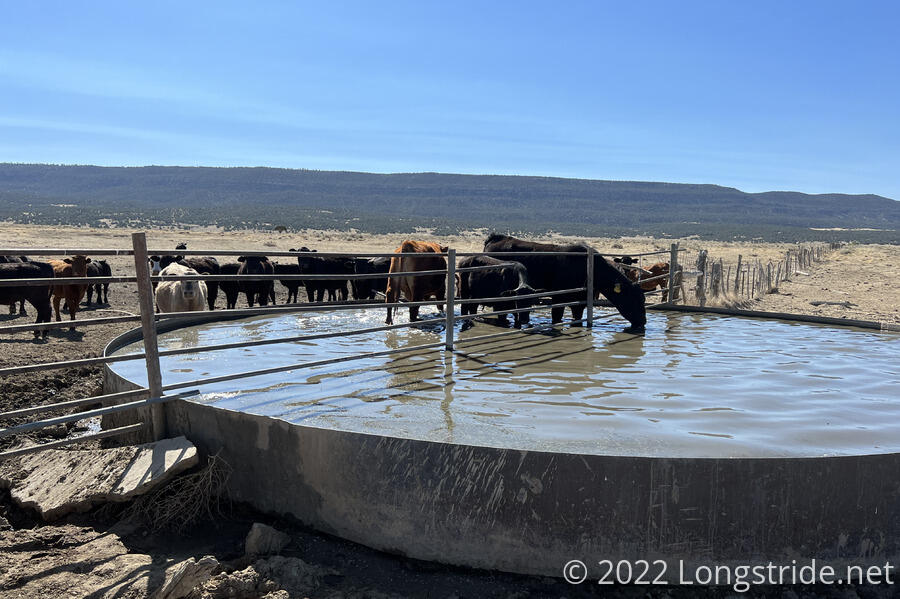
After another 45 minutes I took a detour to the solar well we were supposed to meet at. I actually overshot the intended path to the well, taking a second entrance. This one was a first: rather than a complicated mechanism, this gate was kept closed by a simple rope with a knot.
This turned out to be the wrong side of the cow fence. I had to cross through another gate (while staying away from a herd of cows) to get to the water trough. Dog Bite was waiting there; Mr. Freeze and Plus One had just hiked off.
This was perhaps the most unclean of the water sources I’ve used so far. A whole herd of cows were milling around the water trough, and several were standing in the tank. Dog Bite, who had been sitting there for awhile waiting for us, said that he had observed the cows defecating into the trough, and one of the bulls had been attempting to mate with the heifers standing in the trough.
Fortunately, the water coming from the well was coming through a pipe that looked pretty clean, but the pipe was pretty close to the water level in the trough, making it impossible to get water without the outside of my water bag getting smeared with whatever was hidden under the water.
After collecting what I thought was plenty of water (and also drinking a large amount there), I continued on, returning to the road (via the intended access path) and headed north.
On the side of the road, I passed a dehydrated meal bag, sweet pork and rice, which was the same as what Patches had had yesterday. (But, he was behind me at the time, so I knew it couldn’t have been his, rather just a funny coincidence.)
During most of the morning, to the west of the road were fences blocking access to the El Malpais National Monument. To the east were fences blocking access to a cattle ranch.
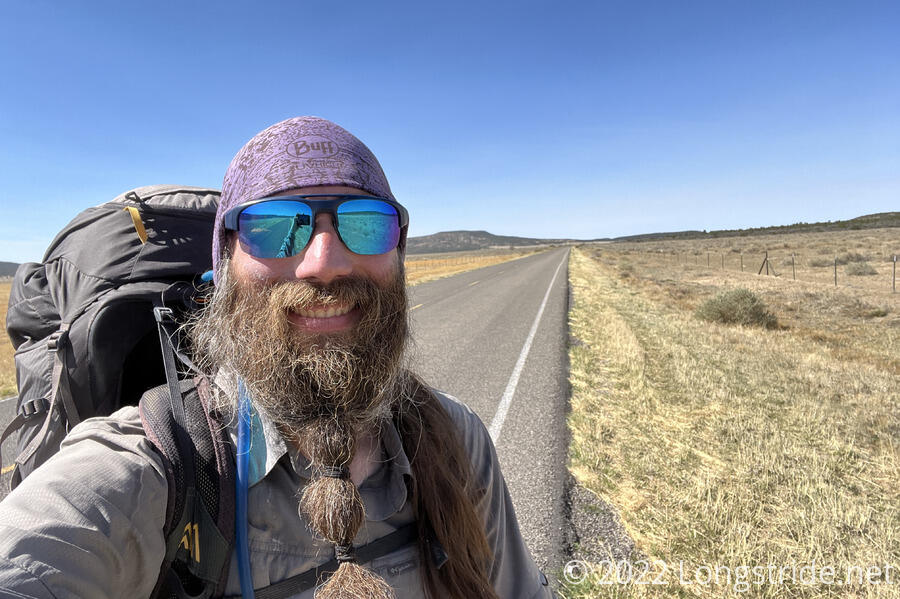
For over four miles, I continued to walk along NM 117. Simple and I stopped for a break at the entrance to the South Narrows Picnic Area just off the road. Mr. Freeze, and two other hikers we’d been seeing for a while, Kiernan and Kyra, were just getting ready to take the Narrows Rim Trail.
An unofficial alternate, the Narrows Rim Trail climbs up the sandstone ridge on the east side of the road. Coupled with a rock scramble to get back down, this alternate cuts off about four miles of roadwalk to the next picnic area, at the expense of about another mile and a half of hiking.
While I mulled over the decision, Patches arrived in a truck towing a small trailer. He had started to have shin splints (or some other leg pain) from the roadwalk, and hitched a ride from a friendly guy. He offered us water; I chugged about a third of a liter from my water bottle and had him fill it back up.
He was going to drop Patches off at our destination for the day, the El Malpais Ranger Station, another 12.5 miles down the road. He offered us a ride as well, but both Simple and I declined, preferring to walk.
Shortly before we finished our break, Patches and the guy drove off, and Dog Bite and Plus One walked up, having been sitting at one of the picnic areas a little further down the road. They had given some of the heavier contents of their packs to Patches to take to the ranger station, so they were going to slightly slackpack the rest of the day. (I’d had that thought also, but didn’t want to ask.)
The picnic area also had a pit toilet and trash can, both of which I took advantage of.
Simple continued along the road. His leg also was giving him trouble, and he wasn’t willing to risk it on a rock scramble. At the last minute, though, I decided to take the Narrows Rim Trail.
After a short climb up to the ridge, the trail continued north, roughly paralleling the road, but at a higher elevation. From this new vantage point, I was able to actually see the El Malpais badlands. From the road, just a short plain and a distant rock wall was visible. But from the ridge, I could see a cracked volcanic rock wasteland, dotted with trees.
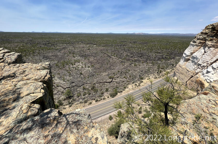
The trail followed a path through reddish sand and rocks, and while it was slower and longer than the road, it was much nicer to hike, and also far more interesting.
The higher vantage point also provided my first view of Mount Taylor, a dormant volcano and the tallest mountain in the Cibola National Forest. The CDT doesn’t summit the mountain, but there is an alternate that goes over, so I was looking forward to hiking over it. But that seems unlikely now, since the mountain is included in the forest closures.
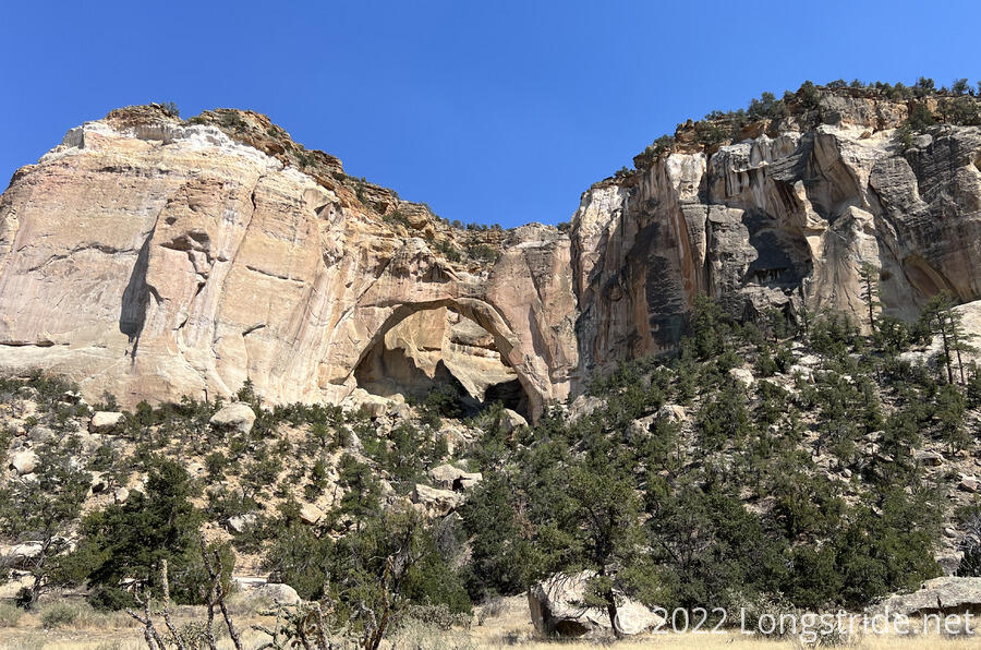
The gem of the Narrows Rim Trail was a vista to the La Ventana (“The Window”) arch, formed by the sandstone eroding over millions of years due to freeze-thaw cycles. At the vista taking a break were Dog Bite and Plus One, Mr. Freeze, and Kiernan and Kyra. I opted to continue on a little further, to the gps coordinates where the rock scramble down the cliff began.
Shortly before I finished my break, Kiernan and Kyra arrived, and headed down the scramble, marked with cairns. Several minutes later, I followed.
The path was clearly marked at first, but then, at some point, I lost the cairns, instead following footsteps. This meant that, if there was an easy path down, I was no longer following it. But, I saw Kiernan ahead of me in the direction it looked like I needed to go, so I guessed I was going in something resembling the right way.
It wasn’t too difficult for the most part, but there were two sections that slowed me down significantly. On one, I took a clearly suboptimal path because I didn’t like how large a drop I’d have had to make from the trail. This resulted in me slowly (but controllably) sliding down a rock face with loose dirt and rock, dislodging far more dirt and largeish rocks than I was really comfortable with.
Later, there was another large drop off, and after starting down, I decided that it wasn’t safe to go down forwards (pack in the way, so I couldn’t stay as close to the rock as I wanted), or backwards (couldn’t see). After climbing back up a bit and looking around some more, I found another path (and footprints) that took a more circuitous but less steep and safer path.
Finally, after about 50 minutes from starting down, I dropped about 450 feet (I think) and moved maybe a quarter to half a mile. It took far longer than I’d expected. But, at least I got a better view of the arch than I did from the vista.
Once I was finished with the descent, I made it to the picnic area in short order, to find everyone else there before me. Dog Bite, Plus One, and Mr. Freeze had gone down an earlier path down the cliff, and it only took them ten or fifteen minutes!
From the picnic area, it was roughly another nine miles on NM 117 to the ranger station we were stopping at. As I was about to start out down the road, I took a sip from my pack bladder and found it to be now completely drained. And my water bottle had only about a third of a liter of water left.
Mr. Freeze generously gave me half a liter of water, which I thought would give me just enough to make it to the ranger station, which I knew had water. And off I went, wanting to get the roadwalk over with as quickly as possible so I could get to more water more quickly.
I stopped for a short break about halfway, and had some water and trail mix, but did not have a full snack, having exhausted my planned snacks for the day. (I could have dug into my pack to get more, but didn’t want to, partially because I was sitting on a slightly steep hill just off the shoulder of the road, and there wasn’t much space to spread out.
By 6:30, I arrived at the ranger station. I went over to the picnic table where Simple and Patches were sitting, conveniently located next to the water spigot.
I was pretty exhausted from the roadwalk and also the rock scramble and the extra miles from the side trail to avoid part of the roadwalk. Almost too tired to cook dinner, but I knew I needed to, because I hadn’t eaten (or drank) enough given what I’d hiked.
At one point, my blood sugar crashed from not having enough to eat during the day, and I had to eat a snickers bar to get it back up to the point where I could actually eat my dinner.
While I was sitting there trying to eat, Simple was planning his next few weeks. He’s going to fly to Florida on Sunday to meet family, and also hike a week or so of the panhandle portion of the Florida Trail, and then come back to the CDT sand continue in Colorado.
Dog Bite, Plus One, and Mr. Freeze arrived maybe an hour after I did. Mr. Freeze had written “BEER?” on her sun umbrella, and within five minutes, they had gotten two cans of beer. Later, they got more water than they could actually use. Also, a number of people didn’t give beer, but raised their open beer cans to show that they had beer.
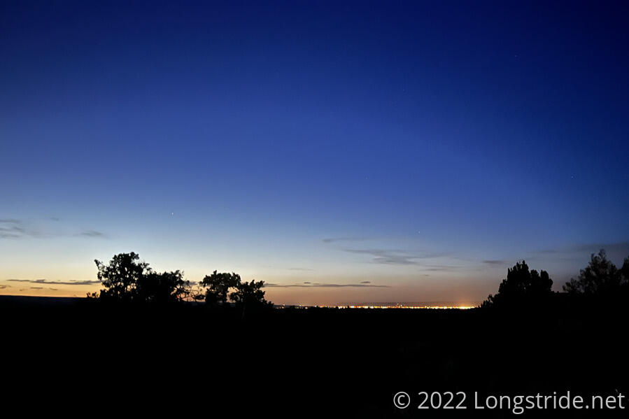
Sluggish all evening, I finally finished eating after sunset, and quickly set up my tent in the waning light. The ground was again soft and sandy, but it was also warmer than it had been. This bodes well for getting up “early” tomorrow to get started on the rest of the roadwalk to Grants (another 15 miles) before it becomes too hot.
The ranger station was within sight of Grants, and the city lights shone out from the horizon. We’ll be there tomorrow, and a planned zero the day after, but after that remains unclear for now.