A long day brought us to a campsite near one of the last snowy passes on the trail.
The early alarm I set last night mostly worked; I left camp a little before 6:30, “only” half an hour behind Pale Ale and Sprouts.
From our campsite, the trail continued north, with a somewhat steep climb up the mountain to a pass. As we guessed yesterday, there really wasn’t anywhere further down the trail to camp, so we made a good decision not trying to push forward looking for a campsite.
Shortly before the pass, I crossed today’s first short snow traverse, cutting off a couple of switchbacks in the process.
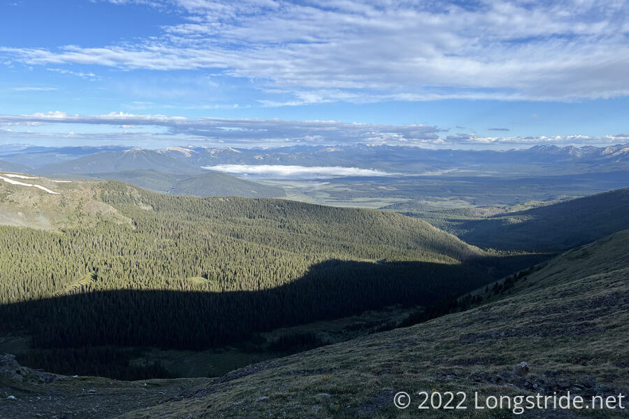
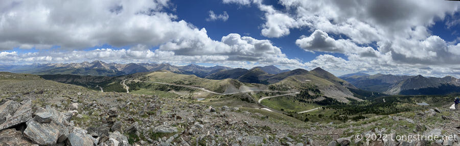
Our trail guide described the pass is having “spectacular views”. I usually take such descriptions with a grain of salt, but there really were spectacular views. Looking west, a nearby mountain formed the western border of the valley that contained the Mirror Lake Alternate that Stumblebee was hiking. A little beyond, the Taylor Park Reservoir had a cloud directly over it. Beyond that, a chain of snow-capped mountains formed a wall that we’ll have to hike over tomorrow at Lake Ann Pass.
Shortly over the pass, I caught up with Pale Ale and Sprouts, who were having a break on the side of the trail, taking in the view.
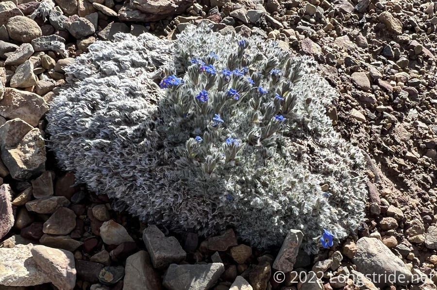
When we continued, the trail continued to wind its way along the side of mountains. As has been common in the Colorado mountains, there’s been a large variety of interesting plants. One I saw today had small purple flowers growing out of a fuzzy base on some rocks.
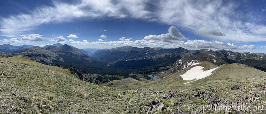
One of the mountains the trail took me past was labeled “Wander Ridge” on one of my maps, and the rather uncreative (but accurate) “Peak 12792” in the app I use to record which mountains I’ve summited. Now being ahead of Pale Ale and Sprouts, and the summit being not very far off-trail, I decided to drop my pack and climb up.
It took less than ten minutes to make my way up to the summit, avoiding a couple of snow fields in the process. The view was well worth the effort. I could even see a lake with a small island in the valley below that I couldn’t see from the trail. (The lake later became visible from the trail once I made a little further progress.) The top was a relatively flat grassy area; one could probably even manage to camp there, if the complete exposure wasn’t going to be a problem.
Returning back to my pack took a few minutes longer; I didn’t really remember the exact path I took up to the summit, so on my way back down, I wound up straying too close to a snow field I’d avoided on the way up.
Later, Pale Ale said that she was excited for me when she saw my pack on the side of the trail and me already halfway up to the summit.
The trail continued along the side of the mountain, overlooking a valley nestled between the ridge and another set of mountains on the other side of the valley. A few lakes broke up the field of green.
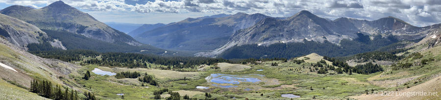
A little further on the trail itself summited a mountain, a little shorter than the one I’d gone off-trail for. At the summit, a large rock wall a couple of feet high had been built, offering some protection from wind.
From this small summit, the trail descended to Cottonwood Pass.
As we got closer to the pass, we passed a large number of people taking the trail to a viewpoint just off the CDT. The wind also picked up a bit, so, tired and cold and quite ready for a break, I opted to skip the side trail and go straight to the pass.
At the pass was a somewhat large parking area packed with the cars of the many people we saw. Sitting down for a snack break, I had to put my fleece on due to the wind in order to stay warm. We briefly chatted with a bicyclist who was planning on doing a rim-to-rim-to-rim hike in the Grand Canyon in a 24-hour period.
From the pass, the trail continued downhill, dropping into the valley of Texas Creek. The initial part of the descent was largely uneventful, though a bird sitting next to the trail let me get within spitting distance before it decided I was too close and flew away.
I stopped for a break shortly before Texas Creek. Pale Ale caught up just after I got my shoes off, and pointed out that, since we actually had to ford the creek, it’d be better to do that before our break. I agreed, and put my boots back on, sans socks, which would have done nothing but soak up water and make the rest of the day miserable for my feet.
The creek was flowing fairly quickly, not quite knee-high, and my shoes got thoroughly soaked. (Compared to the other stream and creek crossings I’ve had on the CDT, Texas Creek certainly lives up to its name; aside from the Gila River, it’s the largest creek I’ve had to ford this trail. (Of course, it’s tiny, compared to any of the fords on the PCT in the Sierra.) Having dry socks helped for after our break, though by the end of the day, they were also somewhat wet, having absorbed the water out of the inside of my boots.
Pale Ale and I (and Sprouts, when they arrived) set out a bunch of stuff to dry out. (We had wet tents and sleeping bags from this morning; I set my sleeping bag out, but not my tent, since I didn’t want to have to stuff it back into its sack a second time today.)
Gray clouds overhead let loose a little bit of rain, sending us scrambling to re-pack the stuff we’d set out to dry so that it wouldn’t wind up wetter than it started.
We continued downhill through the valley. I started to get vibes of the Sierra, due to the way the forest and trail felt, though I’d be hard-pressed to say exactly why it felt that way.
A short while later, we reached another creek crossing. Fortunately for me, this one had a dry crossing, preventing my feet from getting more wet than they already were. Pale Ale and Sprouts opted to just charge through the water, since the dry crossing was somewhat tricky.
We stopped for a few minutes to chat with Gary, a 72-year old Colorado Trail hiker, who had lots of hiking experience (but admitted he was slowing down in his advancing years). He also had a rather incredible amount of kayaking experience as well.
The downhill stopped at the junction with the Mirror Lake Alternate, where I found Stumblebee hiding out from the rain under a (pre-existing) improvised rain shelter made of pine tree branches propped up between two trees.
After a short break to let Pale Ale and Sprouts catch up, we headed uphill through the forest. Initially aspen, after about fifteen minutes, there was a sharp transition and the forest became dominated by pines. A light rain fell for just long enough to be annoying. The sun came out about ten minutes before I reached our campsite for the evening, a large area next to a creek with a few flattish areas for four or five tents.
Our goal for the day was to get as close as possible to Lake Ann Pass, which has been reported to have a small but sketchy snow traverse on its north face. With nearly nineteen miles under our belts today and the pass just over four miles away, we easily accomplished our goal.
Wanting to get over the pass early while the the snow is still hard, we decided to leave camp at 6:30 tomorrow morning, so I turned in a little early.