A miserably rainy 20+ mile hike today brought me to Wyoming, the third state on the trail.
Is took me longer than usual today to get started. Even though I had a 5 am alarm set, I didn’t actually get up until 5:30. But, I thought I slept better than I expected given how hard the ground I pitched my tent on was. And, it was warmer than I was expecting overnight.
Mark and Bella paid a visit while I was finishing packing my pack. He mentioned the possibility of rain; I said I hoped it wouldn’t, and then turned and looked to the west where it was clearly already raining. I put my pack cover on, and hoped that I wasn’t going to have to put my rain jacket on so early in the day, especially with an uphill coming up.
There were reports that the trail’s bridge over the North Fork Elk Creek was still out, and also the trail was significantly overgrown. Not wanting to have to try and cross the creek given how much water was coming down past the campsite, I decided to follow a couple of dirt roads that connected the trail further north after its creek crossing.
I didn’t get very far before it started to rain. Since it actually looked like it was going to be raining for a while, I gave in and put on my rain jacket.
The road wasn’t free of water obstacles either: after about a mile, a much smaller tributary to the North Fork crossed the road. Fortunately, there were some rocks and a log that I was able to use to cross the creek. It was a little tricky, since there were trees growing right next to the rocks and log, with their branches getting in the way a little, but I managed to keep my feet dry. Well, as dry as possible, anyway, given the rain started to pick up.
Right after the creek, the road entered a meadow. Standing in the meadow, near the trail, was a moose. My third moose of the trail, it was entirely too close to me, I felt. And this time, there was absolutely nothing in between us.
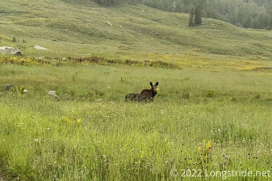
I made some noise and knocked my poles together and got it to move away from me a little bit… right onto the trail. I hiked up a little bit and continued to make noise, and it moved away a little bit. We repeated this dance a couple more times, until it decided it had enough, and ran up the hill out of sight.
With the moose gone, the road reconnected me to the CDT, which took me somewhat steeply up out of the valley I was in. As I reached an exposed ridge, there was a flash of lightning and thunder that came from about a mile away. I tried to pick up the pace a bit.
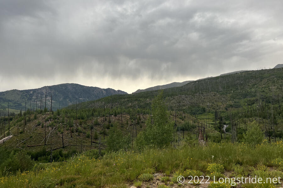
For a couple of miles, the trail followed a meadow (really, though, it was probably a marsh), occasionally weaving into pine forests. It was a bit of a miserable hike, with the trail often being a ditch that was flooded with water.
After being rained on for an hour and a half, the rain gradually diminished, turning into a fine mist. The clouds started to lift a bit, but it had gotten cold out. By now, I was quite thoroughly soaked. I hoped that the sun would soon come out, since that was the only way I was going to get dry.
A steep climb brought me up to near the top of another mountain, the rain having stopped along the way. The sky behind me seemed a bit lighter, and maybe the clouds in front did as well. I didn’t have long to get my hopes up, though, because it then started to drizzle.
I kept trudging uphill, hoping that the rain would stop long enough to stop for a break. It finally did, after I’d hiked almost 8.5 miles, and I sat down on a large rock next to the trail to rest and have a snack. I’d planned for a 20+ mile day today, but given my pace and the miserable weather, I doubted I’d make it to where I wanted to stop for the day.
The trail continued, now going downhill, and joined another dirt road, which at least helped improve my pace a little. The rain continued, off and on. A short but steep section on the road made for slow progress, as the road had become very eroded and rocky over time. The rain didn’t help matters, either, making everything just a little bit slicker.
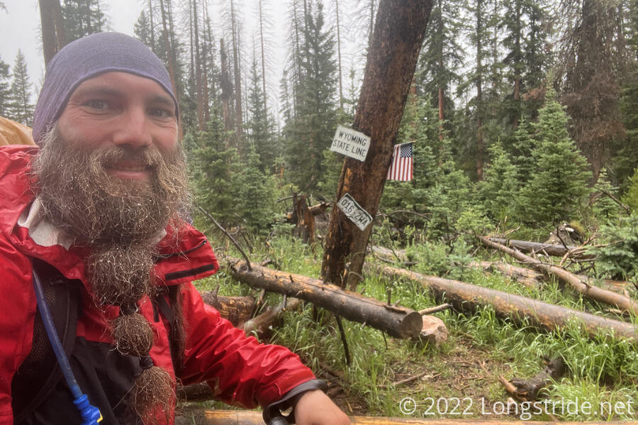
With it still raining, I reached the Colorado-Wyoming border. This was a big relief. Although I still have two and a half miles of Colorado to complete — which I will when I later return to Chama and close the gap between Grants and Cumbres Pass — I’m now finally out of Colorado, and a new stage of this hike can begin.
The trail continued through the woods for a while longer, crossing through a bog with a creek. Not wanting to stand around and filter water from a hard-to-collect source, I kept going, passing a campsite a bit further ahead. That led me to another bog. I wound up following the wrong trail crossing the bog, and wound up in a forest with a mess of blowdowns. Fortunately, my maps showed an old road, and I bushwhacked my way to the road, following it to a large gravel logging road.
Rather than returning to the CDT, I decided to follow the gravel road. There was reported to be water along the road, and it was a little bit less elevation change. Rain aside, it would probably be less muddy, as well. And being road, rather than trail, I figured it would be faster as well. There was also possibly campsites near an intersection, though that would be less than ideal.
I reached the water uneventfully, a large creek flowing through a culvert under the road. It started raining again just as I got there, so I had a not-very-relaxing standing break. A truck passed while I was filtering water, the first people I’ve seen today since I left camp.
I continued to follow the road a bit further. A bit south of the road’s junction with the CDT, I departing the road and charged more-or-less straight up the side of a hill, bushwhacking through a forest, to get to one of the very few campsites my trail guide actually explicitly showed.
The campsite turned out to be pretty lousy, and I followed the trail back down the hill and crossed the road, arriving at the Pipeline Trailhead. There was also not much in the way of good camping here, but since it was a Sunday, I figured that there wouldn’t be much traffic on the road, and I set up my tent behind a tree in a turnaround.
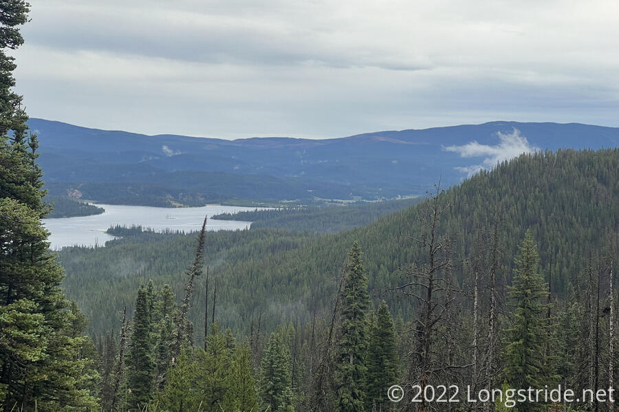
The rain had stopped, and now, a tiny patch of blue sky appeared, at least for a little while. The trailhead overlooked a water reservoir; a few small fog clouds were lifting.
I got my tent up, and changed into dry clothes. Thanks to the rain and wet plants, my socks were completely soaked, and my feet looked like shriveled prunes. While I was cooking dinner, the sun finally came out and the clouds started to clear, but it didn’t take long before the sun sank below the mountains to the west and it got cold out.
Today was a long, dreary day, and thanks to the rain, I only stopped twice for breaks. My feet are not happy with me at all — 70 miles in three days is a new CDT distance record for me. Fortunately, tomorrow will be a shorter day, only about 14 miles to Encampment, the first trail town in Wyoming!.