Today was unexpectedly shortened, but brings an important milestone: the end of Wyoming!
Although our campsite was fairly close to Yellowstone Lake, it was surprisingly dry and warm overnight, which made packing up go fairly quickly. Joe, who had stayed to chat with Velveeta until late in the night, returned to pick us up at 6:30, dropping us off near one of the lodges in Old Faithful Village.
With food being our first priority of the day, Velveeta, Fuck-It, and I sought out the breakfast buffet, which had been reported to be quite good. Learning it was on the other side of the village, we walked there, passing Old Faithful just as it was erupting.
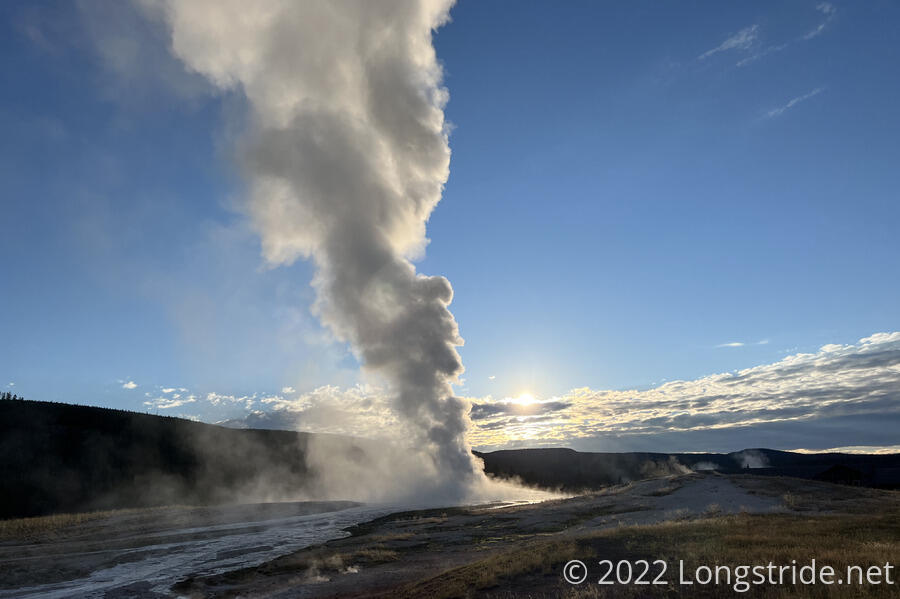
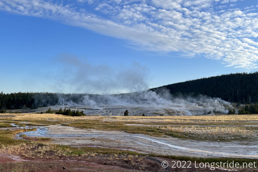
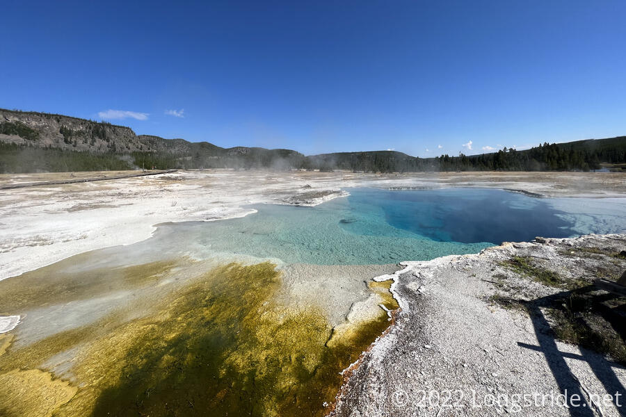
Beyond Old Faithful, on the other side of Firehole River, the many geysers in Upper Geyser Basin steamed, giving the area a spooky, desolate appearance.
From Old Faithful, we went to the Old Faithful Inn, a beautiful multi-story wooden building that practically exuded a feeling of “I am too expensive for you to stay here”. That said, the breakfast buffet at Old Faithful Inn was one of the best I’ve had on-trail (and reasonably priced, too, given the food available). We did a good job of overstuffing ourselves.
Rather than returning directly to the CDT — which leaves Old Faithful Village on a roadwalk — we instead took a detour to Upper Geyser Basin. After all, we were here, so why not take the time to check out the attractions?
We followed a boardwalk behind Old Faithful and crossed over Firehole River, taking one of the paths through Upper Geyser Valley. We didn’t get to see everything there, since we were mostly focused on going “forward” — we still had a trail to hike, after all.
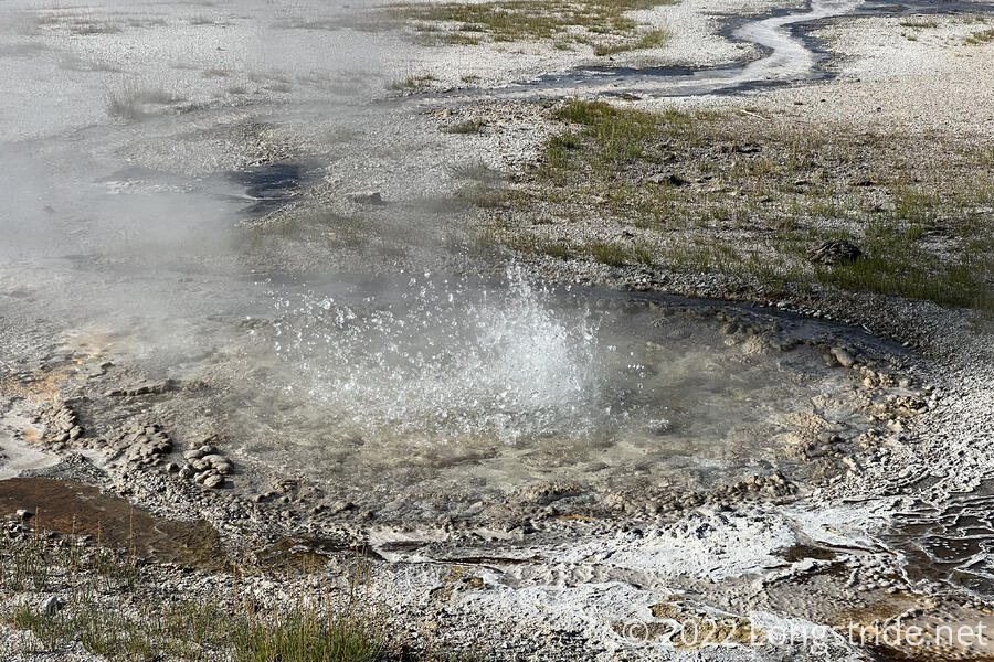
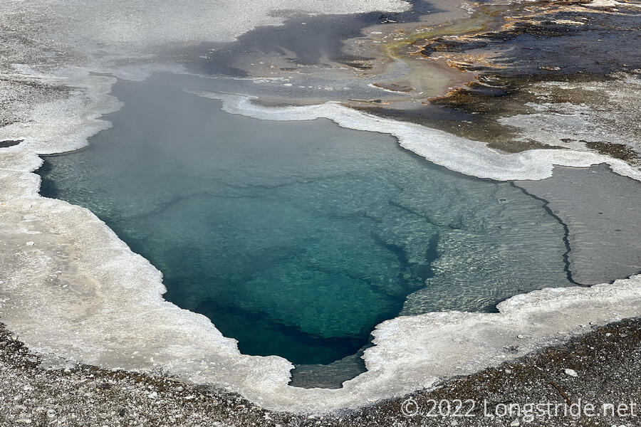
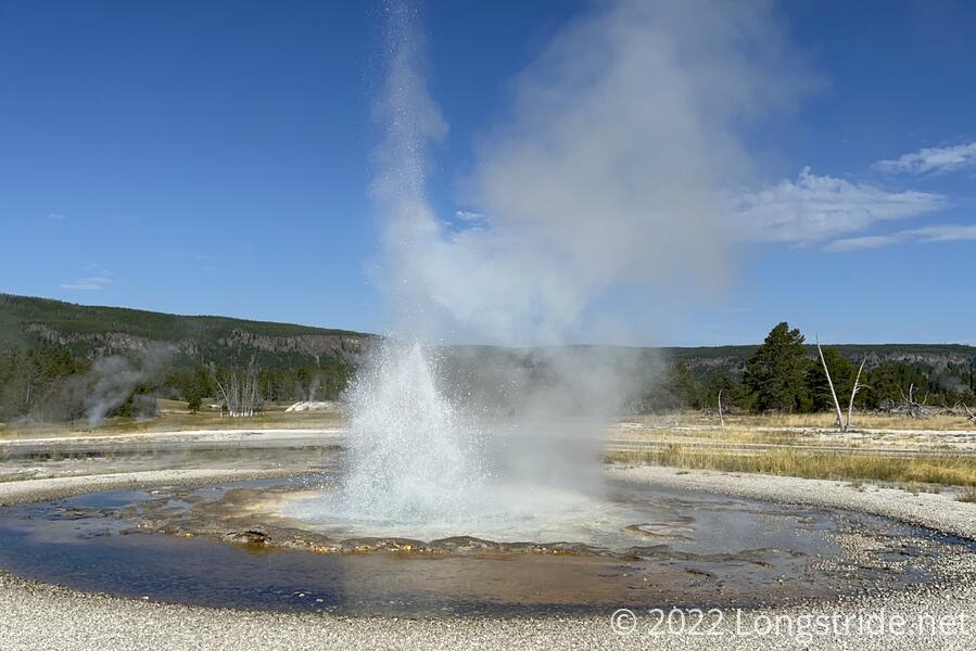
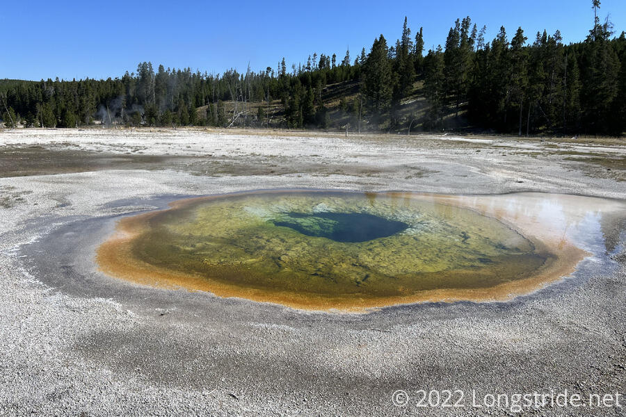
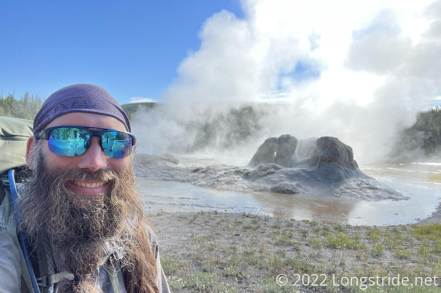
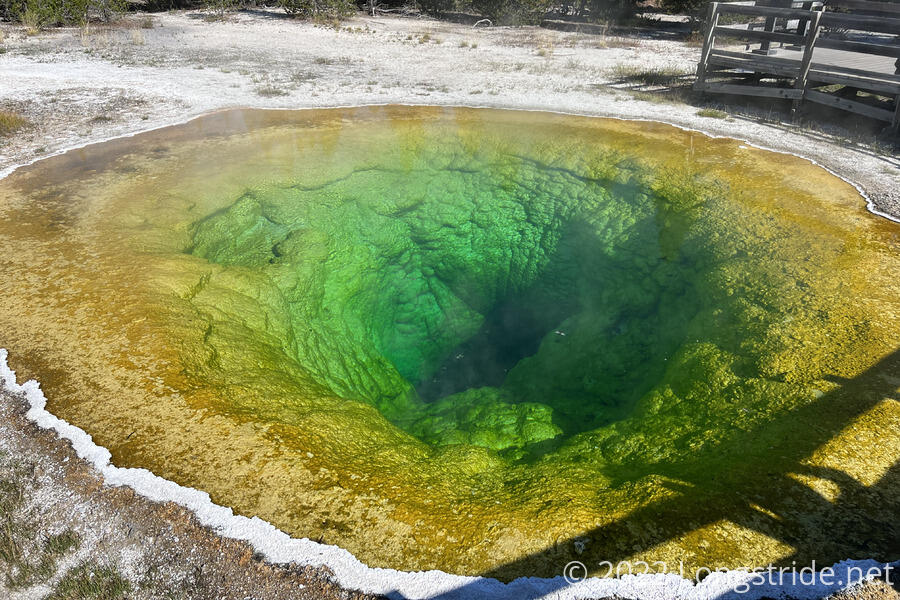
Most of the dozens of hot springs we passed had quite vibrant colors, a result of the different-colored bacteria that grew in different temperature ranges. The geysers took on different forms; some were just water spurting from a hole; others had built up a large mound of minerals around their vents. The Grotto Geyser was unique, in that it seemed to have formed in an ancient stand of trees. Morning Glory’s color, while still quite vibrant, has been fading over decades due to its vents being plugged with trash from visitors.
We passed two southbounders, who told us that another sobo behind them (whom we later passed) had a 27-mile water carry. I don’t think that’s going to be a problem for us since we’ll be diverging from the CDT after West Yellowstone, but it was good to know that water up ahead is somewhat limited.
Crossing a road, we left Upper Geyser Basin and entered Biscuit Basin. The last major hot spring we passed was the Sapphire Pool, a brilliant deep blue pit with a greenish run-off near the boardwalk. After that, the trail took us out of Biscuit Basin. We were now on our way out of Yellowstone.
While we were still near Biscuit Basin, a family passed us (most likely returning from a side trail to a waterfall). The kid pointed at Fuck-It and me and said “Look, Mom! Homeless people!”. (His mother quickly corrected him that we were hikers, not homeless. It was still funny, though.)
We again crossed the Firehole River, and began climbing through a thin pine forest — enough trees to block the view, but not enough to block the sun. Once I finished the steep part of the climb, I stopped for a break.
This morning’s trek through Upper Geyser and Biscuit Basins was incredible. I’ve been looking forward to revisiting Yellowstone the whole hike — the last time I was here was when I was a kid. Just Lone Star Geyser yesterday would have made Yellowstone worth it, but the myriad hot springs and geysers today was truly a sight. I only wish I could have seen one of the park’s mud volcanoes. I can always come back again, though.
After the steep climb, the trail again leveled off, and began a southwesterly course towards the western border of Yellowstone National Park. I was making good time, but with the hot sun and large breakfast, I was feeling a little lethargic and in need of a nap. I caught up to Fuck-It and Velveeta (who passed me on my break), and sat down with them for a bit. Fuck-It gave me a caffeine pill, which did help keep me awake.
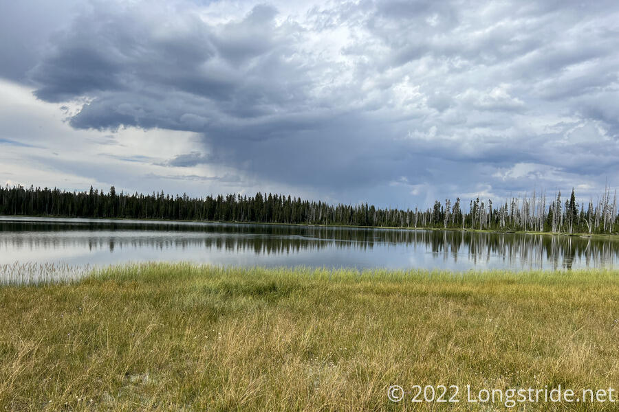
As I progressed up a creek valley, clouds obscured the sun, making it a lot cooler out. It was nice, but I hoped it wasn’t going to rain. In the distance, some thunder rumbled faintly.
Around 2:30, I arrived at Summit Lake, which was to have been our campsite yesterday. I’m glad we didn’t stay here; the campsites were somewhat close to the lake and its outlet, and the ground was fairly soggy.
I stopped to get water — the lake would be the last water for the day. This took forever. My water filter had already been declining in flow rate over the past few weeks, but it really nosedived today. Thanks to the somewhat algae-filled outlet I was collecting water from, it took me almost two hours to filter about four liters of water. (This should normally take less than ten minutes at the very most.)
During the time I was at Summit Lake (with Fuck-It and Velveeta long departed), the clouds to the west grew darker, and appeared to rain in the distance. A two hour delay filtering water killed the possibility of hiking four or five miles longer today, but with a plan to stop at a campsite just past the Yellowstone border, that wouldn’t be a big issue, for today, anyways.
Continuing southwest from the lake, I exited the forest, going through mile and a half swath of burned and fallen trees. I passed a 2000-mile marker on the trail made from thick branches, though I’m a few hundred miles short of that from alternates and the fire closure in New Mexico.
Reentering the forest, thunder quietly rumbled. As I continued walking towards the rain clouds, the thunder gradually grew louder, and a few raindrops fell.
Shortly after six, I reached the Wyoming-Idaho border, which actually is a milestone worth mentioning: I’ve finally completed my first full state on the CDT. (I’m also missing about three miles of Colorado due to the New Mexico fire closure.)
I was a little surprised to see Fuck-It and Velveeta there, eating dinner. I had assumed that they’d be out of Yellowstone by then, given my delay getting water. However, Fuck-It says he thinks he may have a fracture in his leg, so he set up camp at an unofficial campsite at the border, and is going to rest until tomorrow morning. Technically, he shouldn’t camp here because it’s not a designated campsite and we don’t have permits to camp here, but an injury seems to me a legitimate cause for bending the rules. I decided to stay with him out of solidarity — and to make sure he could get out safely if he really does have a fracture. (That it started to rain shortly after I got to the border was just a coincidence, I’m sure.) This means we won’t leave Yellowstone until tomorrow: it’s still another 2.5 miles through Idaho to the park boundary.
I set up my tent as quickly as I could in the rain, and ducked inside, hoping that the rain would stop soon so I could cook my dinner without having to sit outside in the rain. The thunder gradually died out, and after about an hour, the rain stopped. In that time, Velveeta, who was initially on the fence about staying, decided to stay as well.
I cooked dinner after the rain stopped. Tired from getting to sleep late last night, I retired to my sleeping bag relatively early. Some lightning flashed in the distance, but the rain held off, at least until after I went to sleep.