Another hot day took me through the bulk of the Tobacco Root Mountains, on the way to Whitehall.
Given our proximity to a lake, and the grassy campsite, it was surprisingly warm and dry overnight. That was great, but it means it would probably at least as hot today as it was yesterday.
While we were packing up to leave, Fuck-It lost his tent stakes. They were in a green bag, which was easily lost in the rather thick grass around where his tent was. Several of us searched the area for several minutes, and couldn’t find them.
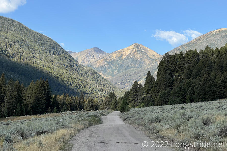
Leaving the campsite, I returned to the dirt road and followed it up and over a ridge. The sun climbed into a thin layer of clouds that helped cool the air a little, but it was still warm, and not even 8 am yet. After gently descending, my route turned onto an ATV trail, which quite steeply and ruggedly descended into a valley.
At the bottom of the valley, I joined a dirt road and turned west, following the road gradually up the middle of the valley.
The road passed no shortage of car campsites, and a few smaller sites that could easily be used by hikers, most with access to a creek. The empty sites, however, had cow infestations, and a number of places that looked like they’d be great for taking a break were “occowpied”.
At an intersection just before the road split between two separate valleys, I caught up with most of the rest of the group, sitting in the shade near a creek, and stopped for a break. On my way there, the forest service guy I saw yesterday passed, and stopped at the intersection, unloading an ATV and going further uphill, seemingly to install a new sign.
From the intersection, the road continued uphill, departing the valley floor and climbing steeply up the side of the mountain to a pass, with no shortage of switchbacks. About halfway up the ascent, I reached a small quandary; the route in my map diverged from the road, following a smaller road and then apparently bushwhacking further up the hill. I assumed this was because the larger road ended (as indicated by my map). However, following the planned route wound up being an annoying 45-minute mistake. While there was kind-of a trail that veered off the road at the indicated spot, the forest quickly degenerated into a mess of blowdowns, and was effectively impassable. I backtracked, followed the road, and discovered that it didn’t actually end where the map said it did. (There was a gate, though, but all that did was prevent ATV traffic. If I’d had satellite maps loaded, they probably would have shown that the road went all the way up to the pass, and I should have just followed it all the way to begin with. I should also have taken the lack of footprints as a clue I was going the wrong way, but there was a little ATV traffic, so it wasn’t unreasonable that it wiped out traces of foot traffic.)
On the way up (and really, ever since reaching the valley and starting the climb), there were a number of disused dirt roads that seemed to criss-cross the mountain. Once I made it over the pass, it became clear they were likely originally constructed for mining operations, and their presence made much more sense.
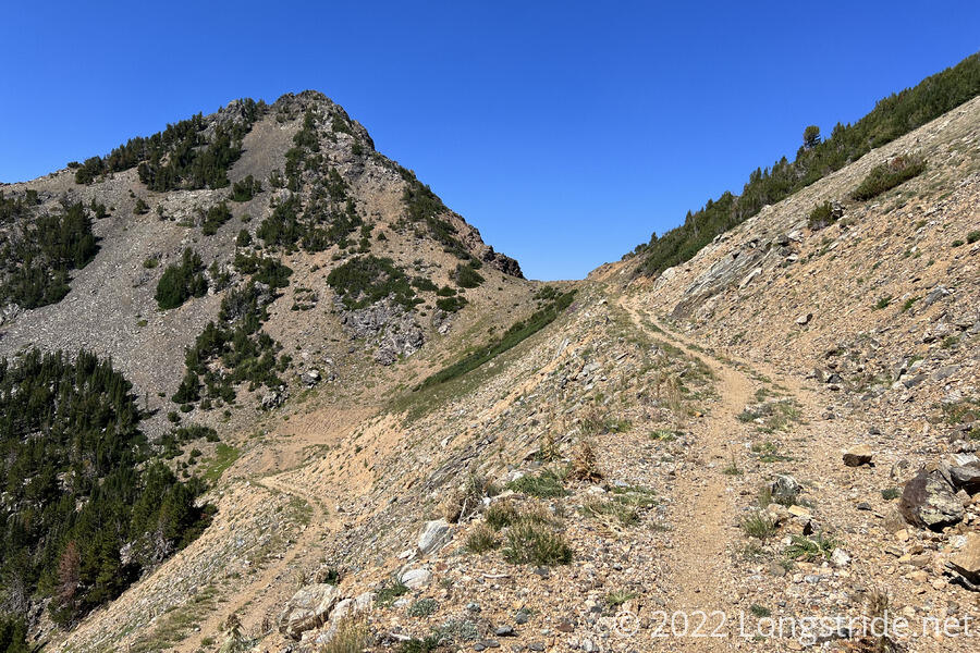
Once over the pass, just below Horse Mountain, I could see the first evidence of mining operations: a couple of wooden shacks built into the mountain, and what looked to be a shipping container at the end of the dirt road.
The trail diverted from the road, dropping down into a valley from its headwall. The initial drop was quite steep, and a little slow, with lots of scree from the steep slopes of the mountain slipping underfoot with every step.
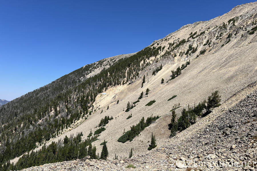
Once I dropped below the scree into forest, a dirt road resumed, dropping into a valley that crossed in front of Hollowtop Mountain, the highest peak in the Tobacco Root Mountains. I passed several mining ruins, including derelict cabins, crates and barrels, thick cables, and rusted-out heavy excavation equipment. It was all quite neat, and I wish I’d had more time to look around more and explore.
I stopped for a couple of breaks on the way down the valley; the second break, over an hour to filter water, allowed everyone else (whom I’d passed while they were on breaks) to pass me. It was still hot out, but the forest at least blocked much of the direct sunlight, making it much more tolerable.
After crossing the South Boulder River by rock hop, the ATV path left the forest, and joined a dirt road that, from a distance, followed the river downstream. There was no shortage of car camping areas, many of which were in use. A few ATVs passed by, including one that passed me once, and then passed me again going the other direction piled with so much firewood that the wood was falling out the back. A couple of pit toilets and trailhead parking lots added a thin veneer of civilization.
After a few miles, the trail left the national forest and entered the small town of Mammoth, where the occasional ATV traffic changed to occasional pickup truck traffic. One local, shuffling down the street very slowly with a walker and his (unleashed) dog, stopped to chat. A long time ago, he hiked a section of the Appalachian Trail, but now was unfortunately in no condition to hike anything.
The sun descended behind the mountains to the west, making the temperature more tolerable.
As I neared what seemed to be the edge of town, I started past a house, and the owner came out to talk, thanking me for staying on the road and not cutting through his property, and giving me two cans of soda and a beer. (The maps I was using called this out. I wondered why that was necessary, but apparently, last year, the map was originally drawn with the route cutting up the driveway and through their backyard to a trail, rather than going around, and it was a problem because lots of hikers took this alternate because of a big fire in Idaho and Montana.)
Just past the house, I caught up with everyone else — Fuck-It, Velveeta, Recon, Wild Man, and Sprouts — taking a break under the shade of a tree, near a creek. They’d gotten a lot of trail magic from a passing car, receiving several cans of beer, as well as some bags of veggies an pretzels. After a while, we moved up the road a bit, to the parking area at the Rock Creek Trailhead, right on the national forest boundary. Not having a better place to camp — at least within reasonable hiking distance with the daylight remaining — we decided to cowboy camp there. It seemed warm and dry, and all of us setting up our tents would both draw too much attention and take up too much space.
I was probably dehydrated today; I’d run out of water in my pack bladder on my way up to the pass, and so was rationing pretty significantly until I got to the creek to filter water at my second break. I had a hard time eating dinner, probably because I was dehydrated.
Fuck-It and Wild Man had “Got Beer?” signs they’d previously made, which they attached to their packs. (It’s why they’ve gotten so much beer.) They put them out by the road, to try and get more while we were cooking dinner, but none of the cars that passed by before sunset stopped to give us any.
The weather is likely to be at least as hot tomorrow as it was today, but I should still be able to make it to Whitehall for resupply.