Last night was one of my most uncomfortable nights on the trail ever. I’m not entirely sure I actually got any sleep, as the continuous winds caused my tent to flap incessantly. It was very loud, and I couldn’t even stretch out comfortably because then the tent’s flapping around would cause it to hit my feet and head. Somehow, I managed at least a little rest, and around 5 am, the winds started to die down and I could “sleep” a little more comfortably.
I got up a little before sunrise, and began the task of defrosting my tent. Fortunately, I had at least placed the tent such that once the sun came up, it would shine directly on the tent, hopefully assisting with the thaw. This took over an hour, but it was worth it. I was able to pack an almost entirely dry tent.
With the wind having died down and it still a bit cold, I briefly contemplated having last night’s dinner for breakfast. Had I done so, that probably would have killed another half hour at least of possible hiking; and while the winds had died down, they had not stoped entirely. It was still cold out, and cooking dinner in the wind while cold still sucks. I opted for my usual pop tart breakfast instead.
I finally started hiking around 8:20, a fairly reasonable starting time, all things considered. From my campsite, I could see another group of hikers a few minutes ahead on the trail, also thawing out their tents, and I hoped they had fared better with the wind. It turns out, they had. That campsite (not listed in my guide; or maybe listed as part of the site where I stopped) was a bit more sheltered, and they said the wind had calmed a bit late in the evening.
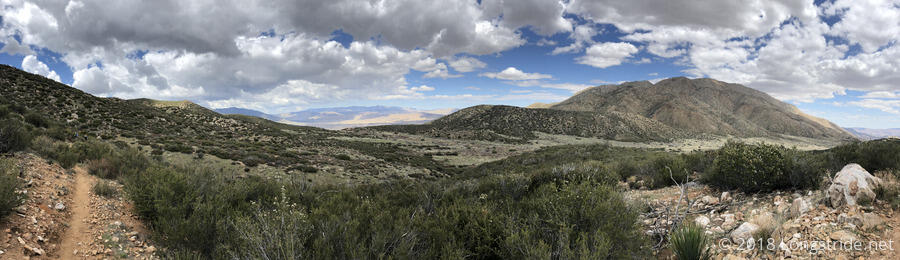
European hiker Wannes hiked with me from there for a few miles to a trail junction to a water tank, and at one point commented that the PCT is like hiking through a painting. To which I added, “and then you turn the corner and step into a different painting”.
At the trail junction, there were a few hikers gathered around the first trail magic food chest on the trail. Mostly depleted by now, it still had a few bags of trail mix and chips. We discussed the upcoming water situation briefly. A water tank about 9 miles ahead and a water cache another 12 or so past that are the only likely water sources for awhile, save for people going into Julian, the next trail town. (I’m not planning on going into Julian.)
Shortly after that, I managed to lightly sprain one of my ankles trying to catch up with the group, who left the cross trails shortly before I did. Wes was kind enough to give me some ibuprofen. (I just happened to buy a bottle of Advil before I left for the trail, you’d think I’d have had the foresight to put some in my pack.)
After sitting down to rest my ankle for a few minutes, I wound up hiking with Meghan for most of the rest of the day. She had caught up from stopping at the trail magic at Cibbets Flats the other day, and it turns out that a picture I took from the ridge past there likely was of her and Norm. Meghan, it turns out, is actually originally from New Mexico, having moved to Australia after getting an Environmental Engineering masters.
Later on, we picked up Patch, who had taken a short, incorrect detour that allowed us to catch up with him, and we hiked to the water tank at the Rodriguez Road crossing. Patch and I traded stories about the Appalachian Trail. While we stopped for a break at the water tank, three other hikers caught up with us.
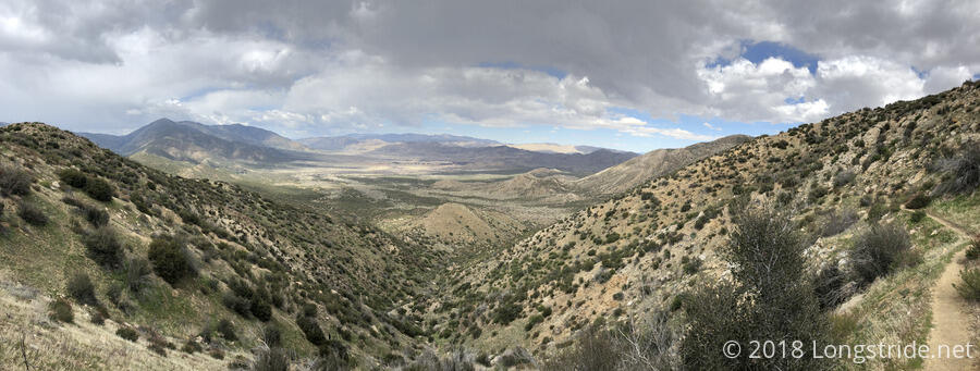
The hike today was mostly downhill, which was helpful since it also wound up being longer than I had originally expected. Starting from a few miles past the water tank, there were numerous closely spaced campsites on the trail leading up to Scissors Crossing and Julian. We pushed on, Patch planing to go the 7.2 miles to the last campsite before Julian; I was happy to try and get there, but tired from my lack of sleep last night, I would have been content with stopping anywhere ahead of where we were.
A very light drizzle fell on us for a few minutes as we were winding around a narrow stretch of trail along a steep mountainside, but apart from a few uphills that slowed me down, the rest of the day was largely uneventful. Patch and Meghan pushed ahead while I stopped for a break near the top of one of the hills, and then I caught up with them at a passable camping area a little further than the last actual campsite. Nearly 20 miles, this was easily my longest day yet on the PCT.
It turns out that Patch has the same tent as I do, and he helped me set mine up, significantly improving its sturdiness. Meghan pointed out that some of the holes in the ground were tarantula nests, so we should check our shoes in the morning to prevent unfortunate surprises.
Tired, and a little cold as the sun was setting, I cooked dinner from inside my tent.
After sunset, there was a crazy cloud formation in the sky to the west, like a flat mashed up rainbow. I wonder if it was the effect of a rocket launch from Vandenberg?
Tomorrow: uphill, that we could see from miles away earlier in the day, across the valley and up the next mountain.