Although the morning was not quite as warm as yesterday, I managed to make it out of camp before 7 am, a new record for this hike. This proved to be quite necessary, as it was warmer today than yesterday (or at least seemed so), and my hiking quickly grew to be quite sluggish once the sun made its way above the mountains. I got in a good 45 minutes of hiking before the first direct rays from the sun hit me.
The morning continued the long, steady climb uphill, vaguely following Mission Creek. Patch (who just happened to leave camp at the same time as me) and I immediately made a wrong turn, veering off the trail as it crossed Mission Creek through dense foliage. We wound up in what was probably an old riverbed, a good 20 feet below the ridge that the trail actually followed. Rather than turning back and finding the correct path to the trail, we instead climbed up the loose, sandy embankment, spilling dirt and rocks down below. (No one else is ever coming up the exact path I took.) Once up top, we saw Dock down in the riverbed as well, and pointed out where the trail was; he found a much easier way up than we took.
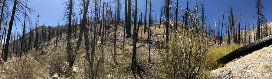
From there, it was a long, slow uphill, with almost 2800 feet of elevation gain over the 6.5 miles to the last crossing of Mission Creek. Making it there, the trail also entered an area burned by fire. Most of the trees were dead, tall pillars of black char and soot, just waiting to fall like dominoes. It was also the start of a potentially long water carry, so I opted to cook part of my dinner there, both reducing food and water weight. The burned trees meant no shade, so while I cooked dinner, the sun continued to roast me.
While I was cooking my macaroni and cheese, a butterfly flew over to my (bright red) fuel canister; I suspect it thought it must have been a particularly enticing flower. Failing getting anything useful from the side of the canister, it then flitted around a bit and landed on the packet of tuna I was in the process of scraping into my cook pot. Before I could get a photo, it flew off and landed on Patch’s pack, poking at a bandana, before moving on to actual flowers.
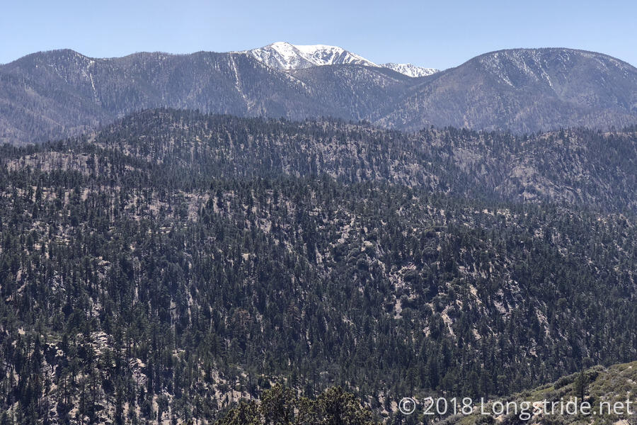
The hike from that last stream crossing continued to be long and slow, but as the day progressed (and the altitude increased), it started to get cooler, and by mid-afternoon, a light breeze developed. This made for much easier hiking. A great view of San Gorgonio came almost out of nowhere, as the trail rounded a corner.
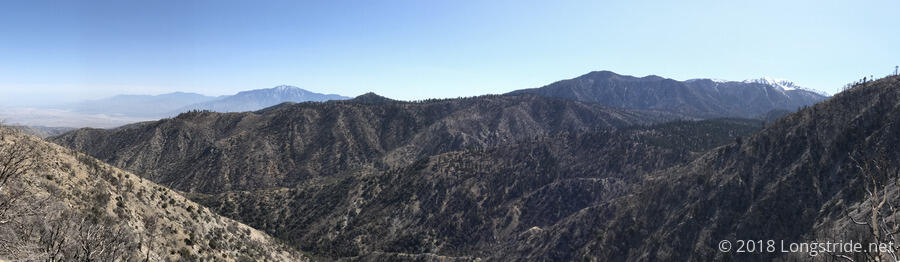
The trail today meandered quite a bit, and even though I progressed down the trail 14.4 miles, I ended only 4 miles away from where I started. I had a vague idea this was what was happening, but San Jacinto coming back into view, with the wind farm in the foreground, really made that clear.
I reached the Coon Creek Camp sometime around 4, and sat down for a snack next to a small (but very welcome) water cache. Dylan arrived shortly after. After Patch arrived, we investigated the camp, Patch and I having decided to stop here for the day. (The next campsite is on the top of a hill, and it was starting to get windy, and the campsite after that was too far to reasonably make it to today.) The camp consists of a set of three “historic” buildings there, somewhat reminiscent of an Appalachian Trail shelter, but the buildings are all in very poor repair, and there were signs of significant mouse droppings. Patch called it a health hazard, and possibly structurally unsafe. Apparently, though, the site can be rented out. Seeing the condition of the structure, I can’t imagine who would do so. Instead, we opted to set up our tents a little bit down the trail in a sandy area relatively shaded from the wind.
Later on, Quoi arrived at the water cache, and joined us for food. Around that time, I noticed a truck had pulled up to the cabin, and it looked vaguely park-rangery, so I went up to see if maybe they would have keys to unlock the privy.
Already talking with the ranger was Squish. What ensued felt like the dumbest conversation I’ve ever had with a park ranger. I said I was hoping they might have keys to the privy. They asked, “Why?”. A little surprised (because, why else would anyone want to get into a locked privy?), I responded, “So we could use it.”, trying to be polite and not give an incredibly snarky response the question deserved. “No, for paying customers only”, was the response. But, we could stay in the cabin, if we liked. I mentioned that it looked like a health and safety hazard, and the ranger said something to the effect of, “If you’re hiking the ‘PC Trail’, you should get used to that sort of thing.” I was so surprised by the flagrant disregard for health and safety that it didn’t even occur to me to say that on the AT, a structure in such disrepair would have long ago been condemned, destroyed, and rebuilt. I mean, I’m grateful the ranger was willing to let us stay in the cabin for free, but even hikers should have standards, especially where health and safety are concerned, and just because the cabin is a historical building shouldn’t give it a free pass.
After the ranger left, Squish joined us for dinner, and we had a good, long conversation, before it ultimately got too late (and too cold), and we all retreated to our tents.
Over the past week or so, at the end of the day, the top of my left foot had been hurting. Yesterday and this morning, I slightly loosened the shoelaces over that part of my foot, and the pain has now all but gone away.
Tomorrow: stop at the tentsite just short of California Highway 18, and go into Big Bear Lake early on Friday.