A “short” day took me most of the way up the Deception River.
It felt like I slept forever last night — or at least, it felt that way every few hours when I woke up and it was still earlier than it felt it should have been.
I had set a 6:30 alarm this morning, but didn’t really get out of bed until almost 7. I felt better than I did yesterday, but still tired, and cold.
I had the option to extend my stay another night and slackpack the whole of the Deception River and Goats Pass and Mingha River track to the other side of town. I decided not to, though. I was tired of Arthurs Pass and wanted to be gone, and I didn’t want to have to deal with the two additional hitches that would require. But also, I was a little nervous that I couldn’t do the whole stretch in one day. So I left the lodge with my full pack and returned to the village to hitch out.
Back in town, in front of the cafe, It didn’t take too long to get a hitch back to the trail. There wasn’t a whole lot of traffic, but after about ten minutes (which felt like much longer, since it was cool and windy), a guy in a sports car who had been sitting in front of the cafe asked where I needed to go, and the footbridge back to the trail was on his way, so he gave me a ride. 20 minutes later, I was back at the trailhead.
After recrossing the Morrison Footbridge, the trail began to follow the Deception River upstream. According to the ranger at the DOC visitor center I spoke with yesterday, the river is so-named because its flow rate is deceptive. The lower portion of the river, where it flows into the Ōtira, is on a deep shingle bed (apparently 100 meters thick), so half the river’s flow is underground. A bit further upstream, the shingle dissipates, and the river is fully above-ground, giving the appearance of a much higher flow rate than downstream.
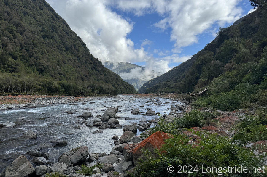
After following a proper trail for a short while, the trail disappeared, leaving me to follow the rocky (but dry) riverbed a fair distance from the river channel.
This was slow. It took me three hours just to hike 5.6 km. (Partially, my slowness is due to trying not to stress my left ankle too much, but still, I should have been faster than that.) During that time, I crossed the river three times, following the orange markers, and occasionally getting a short stretch of clear trail, by which I mean, a path through the rocks where the red lichen had been rubbed off by hikers. At least the river itself was clear and at most just above knee-deep, usually only in the center of the channel. You couldn’t really tell that there had been a big rainstorm two days ago.
I stopped for a break after the third river crossing, at a decision point: the arrows pointed into a forest trail, but there was also a path through the rocks. When I continued, I opted for the rocks: I could see the trail, and it seemed reasonable; the forest was probably going to be overgrown or a pain to hike through.
I can’t know whether just following the path in the riverbed was better than the forest path or not, but it got me where I needed to go, which was further upstream, without getting stabbed at by overgrown plants.
The second half of the day seemed to go faster than the first half. I’m not sure if that’s because the trail was easier to find, better signed, or I just got better at following the trail. I passed by two more northbounders, as well as did two southbound day-hikers. I saw another southbounder, who seemed poised to overtake me going uphill, but then I lost them when they fell behind as we took different paths along the riverbed, and I never saw them again.

The trail did really get nicer for at least a little while, before becoming steep, rugged up-and-down rock scrambles on narrow trail above the river. At least the trail stayed on the river’s left bank most of the afternoon, and I only had to cross smaller creeks. When the trail did cross back to the right bank, it was as it reached Upper Deception Hut.
As I arrived at the hut, I ran into two northbounders who were on their way out. They’d started from the trailhead south of Arthurs Pass roughly about the same time I started from the Morrison Footbridge. Now 4 pm, it had taken me seven hours to go 11.7 km up the river. Really not a good time. I blame both my ankle sprain, as well as the cold I had, which was sapping a lot of my energy and didn’t really seem to have improved much.
In the hut was another nobo, Marcela, from the Czech Republic, whom I’d met yesterday when I was at the DOC office. Later, three more sobos arrived, nearly filling the six-person hut.
Tomorrow, I’ll need to make it the rest of the way up the Deception River, over Goat Pass, and down the Mingha River to the road. Unless I make it very far tomorrow (which seems unlikely), I’ll probably have to go back to Arthurs Pass again. If I’d been able to make to the other side of town, I’d have enough food to make it to the end of the next section. But only making it half as far as I planned today means I’ve used an extra day of food which I’ll need to make up for in town. I’m glad I decided against attempting to slackpack the whole section today. Even with a light pack, with as long as it took me to get as far as I did, I probably wouldn’t have made it the rest of the way; I’d have had to go twice as fast as I did today, which didn’t seem likely.