Every time I go hiking, I am reminded just how bright a full moon is. With streetlights and indoor living, the brightness of the moon just isn’t clear. Last night was the first time I noticed the moon this hike, and it was every bit as bright as I remember from prior trails, bright enough to walk around without a headlamp and still see where you’re going.
It was warmer than I was expecting last night, at least until some time early in the morning, when it got quite a bit cooler. Once the sun came up, it was a little bit cloudier than it had been in prior days, though I’m not sure the clouds really did much to shield CareFree and I from the sun.
We managed to leave camp earlier than we did yesterday, leaving the Toccoa River and heading north around 9:40. Two of the hikers that camped on the south bank of the river were still there when we left.
About twenty minutes after we left the river, we finally ran into our first BMT hiker, who was nearly finished doing a loop of the Appalachian and Benton MacKaye Trails, starting from Springer and taking the AT to Fontana Dam (just south of the Smokies), and then turning south onto the BMT to return to Springer.
Today, the trail took us over several mountain summits. The first was Toonowee Mountain, which had a relatively steep climb and no view. On our way down, we passed two more hikers, an older couple. They were just out for the day, doing a six-mile out-and-back between the next road crossing and Toccoa River.
Yesterday and today, I’d been noticing some very faded blue blazes on trees, sometimes with the BMT blaze, and sometimes on their own trees. They were so faded it was hard to tell what their shape was supposed to be. I suspected the blue blazes might be for the Duncan Ridge Trail (one end of which starts with the BMT when it last split from the AT). I finally got my answer at the road: a sign for the trail named both the BMT and DRT, showing each trail’s blaze, which is a blue rectangular blaze for the DRT. (The BMT uses a white diamond.)
But, speaking of blazes, so far, I’ve been impressed with how well blazed the BMT is, and how good the blazes look. Relatively few blazes look notably old and worn. I also haven’t wondered if I was still on the trail like I often wondered on the early AT. (I’m not sure if this is because the BMT is better marked, or I’m less worried because I’m more experienced.)
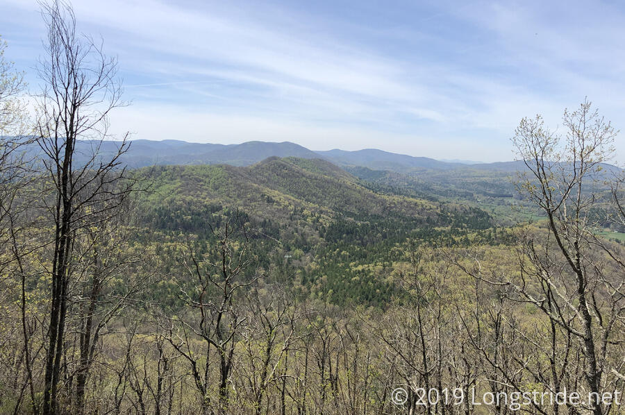
After just under five miles, we stopped for a much-needed break. Now on our second steep climb of the day, we were running out of steam. We kept the break short, about twenty minutes, and continued on to Wallalah Mountain. As before, there was no view from the summit, but the trees thinned on the way up, opening a view to the south.
We struggled our way up the third of our steep climbs, to Licklog Mountain, stopping there for our second break. A nice breeze greeted us there, at least for a short while. Licklog was also lacking a view, though we did notice that there were a lot of ants and butterflies flitting about.
After our break, we repeated the pattern we’d done twice before today: drop down from the mountain a bit, and then make a steep climb up the next one. This time, it was to Rhodes Mountain, which would be our last summit of the day.
The BMT doesn’t actually summit Rhodes, though; instead, the Duncan Ridge Trail splits from the BMT and heads east, back towards the AT, and the summit is a tenth of a mile up a steep (even by BMT standards) hill. CareFree elected to take a short break at the trail junction, while I climbed up to bag the summit (and, I was hoping, a view). At the top was a fire ring and a tiny campsite, and again, no view. Also there was a ripped and faded orange and white hanging contraption of some kind with a lock on it. There was one on the summit of Wallalah Mountain as well, and in neither case was there any indication what it was. I presume some sort of forest service management device.
From the trail junction, the BMT began its westward turn, and we headed down off the mountain to a road crossing. On our way down, we passed some recently-installed stairs; the dirt still showing signs of having been freshly turned. Trekking pole marks on each tier showed at least one other person had been here since then, probably the hiker we saw this morning.
Signs of trail construction had been fairly evident yesterday and today; there were quite a few stairs in different locations that had obviously been constructed (or reconstructed). Overall, the level and quality of maintenance on the BMT seems to be pretty good — actually, much better than I was expecting.
At the road, a bright orange sign announced a prescribed burn for “mid Feb - Mar”. It didn’t look to me like a burn had taken place.
After crossing the road, we began our last climb of the day, not quite as long as each of our earlier climbs, but broken up with several short downhills. Especially by this point, we were pretty tired, and had to stop far more often than we’d have liked for short standing breaks in the shade.
With the tree cover not fully in, we’re both getting sunburn. Fortunately, it’s not too bad, but I was hoping that there’d be enough tree cover to make it a non-issue, based on my experience on the AT. I suspect that I didn’t get burned much on the AT because it was cool enough to wear my long-sleeved fleece while hiking for at least a few weeks, and by the time that was no longer necessary, the leaves had grown in more.
We finally arrived at Payne Gap, 12 miles from Toccoa River, around 4:45. The first order of business was making sure we’d be able to get water; the guide said there was an intermittent spring. We dropped out packs at the campsite just a short distance away from the gap, and after a quick jaunt down one of the many old roadbeds in the area, we found the spring. It took some searching in the stream bed to find a place where we could collect water. It left a lot to be desired, but it was far from the worst water source I’ve seen. (CareFree would disagree, though.)
We had hoped to be able to do another four miles to the next campsite with a spring, to reduce the distance we’d need to hike on Friday to get into town, but after all the mountains we had to hike over, we were exhausted.
We set up the tent, filtered our water, cooked our dinner — which made everything better — and got into our sleeping bags, and this time set an alarm for tomorrow: we wanted to get up early enough that we’d have enough time to get in extra miles tomorrow: the weather forecast calls for rain on Friday morning, and the less time we can spend hiking in the rain, the better.
As we went to sleep, a very loud bird started chirping at something (for no reason we could discern). It shut up after a while, and an owl hooted even more loudly for a minute. Then the first loud bird chirped away a bit more, as if to have the last word.