A very long day today was set in motion by something we can’t yet control: the weather. With a sizable storm aiming at us, we pushed further than we planned in an attempt to stay as dry as possible tomorrow.
It was warm overnight, and with a light breeze blowing, it was very nice this morning. The alarm we set successfully got us up at 7 am, but it still took CareFree and I almost two hours to finish camp chores and start hiking. We left camp around 8:50 am, a nice breeze propelling us up the mountain as the sun crept over the nearby hills.
Naturally, the day began with a climb. But, which mountain we summited was unclear. The sign at the top said “Wilscot Mountain”, but my maps showed that we were on “Deadennen Mountain”, with Wilscot being a separate peak to the southwest that we passed alongside about a mile later. Ordinarily, I would defer to whichever name Peakbagger.com lists, but it doesn’t seem to have the mountain in its list at all!
As we descended the mountain heading south, we passed by a stretch of trail that had been immaculately groomed. Someone had swept all the leaves off the trail for a good distance. As we approached a switchback, I saw a pair of pink ribbons attached to a tree. I guessed (correctly) they marked the end of the maintenance, and indeed, the leaf litter returned to the trail.
Reaching the next road, we found another prescribed burn sign for mid-February through March, and no clear sign that there had actually been a burn. We also saw two cars in the parking area, and so we expected to see day hikers at some point. While we did see day hikers later in the day, it seemed unlikely the cars belonged to them.
Passing the road, the trail again turned uphill, as we began our climb of Tipton Mountain. As we climbed, we decided it was It was noticeably more humid than it was yesterday, though it was a little bit cooler, and the sun was a bit more obscured by clouds.
The trail heading up to Tipton had a number of unusual features. There were several snail shells that we noticed, embedded in the dirt. Several different kinds of millipedes scampered about. And the head of (presumably) a trail maintainer’s hand trowel was embedded in a tree, its handle tied up and dangling from a nearby vine.
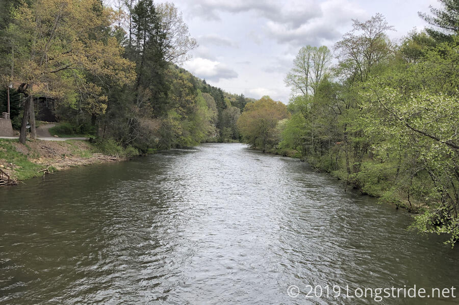
On the way down Tipton, thorough the trees, we could make out Blue Ridge Lake, adjacent to the town of Blue Ridge, and into which the Toccoa River flows. (We camped at that river two evenings ago, and will cross it again later today.)
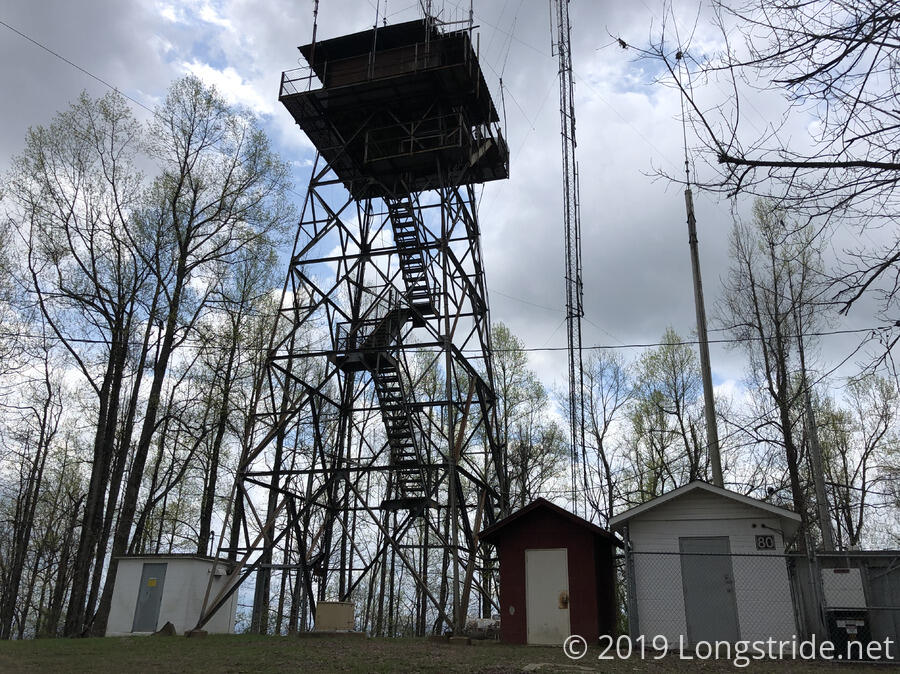
After descending Tipton, we stopped at Ledford Gap for a break. A nearby dirt road led up to the summit of Brawley Mountain; the BMT climbed up to the summit via a separate trail. The summit housed a fire tower and what appeared to be communications equipment, but again, no views. Unfortunately, the bottom flight of stairs to the tower had been removed, making it impossible to climb the tower — which I’m sure would have had a nice view over the area. (Otherwise, what would be the point of a fire tower?)
As we descended Brawley, the wind began to pick up, and the clouds in the sky appeared to be darker. CareFree was initially worried we were going to get rained on, but I was fairly sure the clouds weren’t going to rain — on us, at least, not yet.
Eventually, we reached Shallowford Bridge road, which the trail then immediately circumvented by leading us on an (otherwise) pointless up-and-down on the neighboring hill. We got another glimpse of Blue Ridge Lake along the way. And, we saw what looked like wooden supports for two teepees in a small clearing aside the trail.
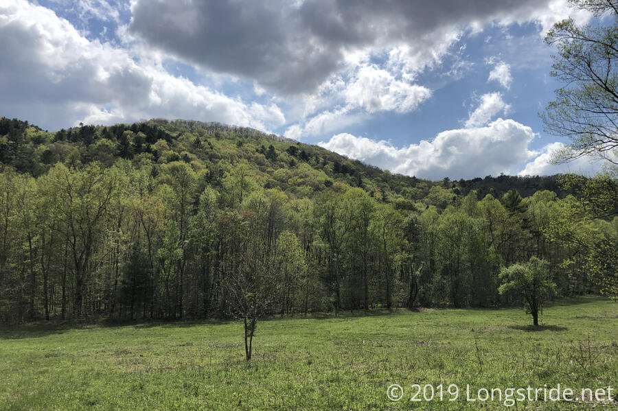
At some point during the day, I realized, I was quite happy with my decision to start the BMT in mid-April, rather than the end of March (as was my original plan). The extra few weeks has allowed the trees to start getting their leaves, and while we don’t often have full views of the surrounding landscape, when we do get glimpses of the surrounding hills and mountains through the trees, they are much more green and colorful than I remember the AT being at the end of March.
The BMT eventually exited the forest and rejoined Shallowford Bridge Road, beginning a roadwalk that reminded us a bit of the roadwalk out of Stehekin on the PCT. The trail (such that it was) followed a one-lane gravel road, with a river on trail-west. A lone kayaker paddled past, heading towards some rapids.
After about half a mile, we crossed the Toccoa River again on the one-lane Shallowford Bridge, and stopped for lunch at the Iron Bridge Cafe and General Store.
Fueled up with a burger, soda, and ice cream, we continued along what I think is one of the worst roadwalks I’ve ever done.
For another half mile, the trail followed Aska Road on the other side of the river, a two lane road with small, but usable shoulders. Then, the trail turned onto Stanley Creek Road for the next three miles. Stanley Creek was also a two-lane road, but it was a windy mountain road with barely any shoulders to speak of. Fortunately, there was fairly light traffic, so we didn’t have to step off the road too frequently, but as far as roadwalks go, there was a lot to be desired. I also got the distinct feeling that our presence was unwelcome; every home we passed had no trespassing/violators will be prosecuted signs of various sorts, from quite serious, to barely humorous (“trashpassers will be prostituted”).
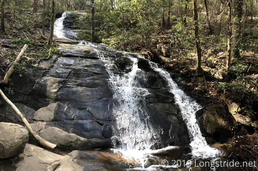
The only redeeming value of the roadwalk was that it was largely flat, so we were able to walk the 3.5 miles of road in just over an hour. The paved road turned into a gravel road, which then led to the trailhead to the Fall Branch Falls. We took a break at the trailhead to rest our feet and discuss our options for the day.
Our initial plan for the day was to go another mile and half up the mountain to a campsite. That would give us about 7.3 miles to get to the road into Blue Ridge tomorrow. But, with severe weather called for overnight and tomorrow, getting as far as possible today would be preferable so that there’d be less hiking in the rain tomorrow. It would be really beneficial if we could get over the mountain and further down into something resembling a sheltered campsite. Our stretch goal for the day would be a further 4.5 miles from where we were. It being 4 pm, that would likely mean we’d get there around 6:30 or 7, later in the day than we’d prefer, but at least before dark.
The Fall Branch Falls was evidentially a popular location to visit. While we were resting our feet and planning, two groups left from the parking lot to walk up to the falls. One of them, we passed on our way up.
At the top of the falls, we took a brief break to get water. Having had a big lunch, we got enough water to ensure that we’d be able to make it to town without cooking dinner tonight, in the event we couldn’t make it to the campsite we wanted, which reportedly had water. Just before we took the side trail to the top of the falls, we saw two day hikers returning down the BMT from further north, making them the first BMT hikers we’d seen all day.
As we continued climbing, the skies got a little more cloudy, and the wind started to pick up. Now several hours from when we had lunch, we stopped at our original destination for the day and took a short snack and foot-resting break.
The trail, still in the middle of its currently-westward track, took a turn to the north, going up Rocky Mountain. Near a pair of large fallen trees, some trail maintenance had been completed, and we saw a tire track in some damp mud. Because of the maintenance, I assumed it was from a cart used by the maintenance crew; the other obvious alternative was that it was from a mountain bike, and I didn’t think we saw enough damage to the trail from the track to think it was a biker.
As with Rhodes Mountain, Rocky Mountain was a short side-trail off the BMT. Again, CareFree opted to wait at the trail junction while I made the quick climb up to the summit. As I expected, there wasn’t much of a view, but there was a nice campsite at the top. If it weren’t going to be raining overnight (and, I suspected, a thunderstorm given the approaching storm was likely the same one that had caused tornadoes and power outages in Louisiana earlier in the day), it would have been a nice place to camp.
We reached the our campsite, a short distance off the BMT down an old road bed to a creek, just before 7 pm. It looked like there were three options for campsites. There was an obvious space right next to the fire ring. A little further uphill on the road bed, the road had been cleared of debris where someone likely camped recently. Expecting lots of wind and rain overnight, we chose a site up a small hump just before the fire ring, and protected on three sides by Rhododendron trees. All three spaces were fairly small; I think we went for the largest one available and even then, we barely managed to make the tent fit.
Hoping to keep water from coming down a higher hill and flooding our tent, CareFree dug a couple of small shallow water channels next to the hill. Unfortunately, I kept accidentally stepping on them while getting stuff out of my pack and getting ready for dinner, rendering them less effective, even after I went back and tried to touch them up. At best, I think all they’re going to do is help keep rain water that washes off the tent from immediately running underneath, which would be an improvement, at least. I guess we’ll find out tomorrow morning.
We collected water for dinner, and I didn’t start cooking until almost 8 pm. As luck would have it, my dinner tonight was the leftover meal I had from the PCT, which had since spent over six months sitting in my cupboard. It was not as appetizing as I was hoping for; some of the oil leaked out of the cheese package in my macaroni and cheese, and so dinner tasted a bit off. (If I hadn’t already had a big lunch, I might have complained about it less; mostly I ate it so I wouldn’t have to throw out a pot of otherwise good food.) I opted not to cook my ramen. I’d had enough food for the day, and the sun had already set by that point.
As we were discussing the day while eating dinner, we realized that, not only was this the longest day we’ve had on the BMT (19 miles!), it also had over 4,000 feet of elevation gain and loss. I’m surprised we did as well as we did today; we had a much easier time of it than I would have expected, especially this early in the hike.
After the sun went down, CareFree and I both thought we saw a flash of lightning that the other didn’t. I suspected it was just a trick of the light, especially since there was no thunder to follow up.
As we cleaned up after dinner and packed as much of our stuff as we could inside the tent (making it a bit more cramped than usual), the wind continued to pick up. The weather forecast was still not calling for any rain until very early tomorrow morning, so about all we could do until then was to try and get some sleep...