A long, rainy day put me in a good position for tomorrow’s hike to the high point of the CDT.
Expecting a long day today, as well as rain, I set an alarm for 5 am and wanted to get hiking by 6 am. Naturally, I didn’t actually get started until almost 7.
In the morning, it wasn’t quite as warm as it was yesterday, I think because the sun was mostly hidden by the mountains.
I saw a lot of Colorado Trail southbounders this morning. There must’ve been a lot of them camped somewhere relatively nearby. Today however, is the last day that I’m going to see anyone who’s hiking the Colorado Trail: the overlap between the CDT and the CT ended a couple of miles from where I camped.
Before the Colorado Trail split off though, I met Lady Scout and Chicken Legs, who wanted to take a picture with me since I was the first CDT hiker they met. And I also met No Trace and Unbreakable, who hiked the CDT in 2012-2013, and are triple crowners. No Trace asked what my average mileage was on the PCT; I said it took me six months, so about 14/day; he said I was probably the most honest person on trail, since most people he asked immediately started talking about how they did 30-35 mile days.
Both yesterday and today, a fair number of the CT hikers I passed congratulated me. This didn’t really make much sense, unless they thought I was a CT nobo, in which case, I would be “almost done” the CT. (Though granted, I’ve still hiked almost twice the length of the entire CT so far.)
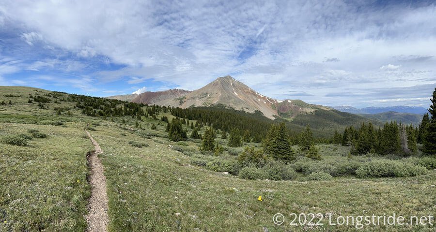
At the northern junction with the CT, the CDT turned onto a dirt road, which it followed briefly before going through a fence meant to block ATVs from driving off the road and onto the fragile tundra meadow. From there, the trail climbed straight up the mountainside.
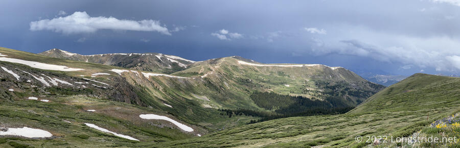
From the road, the trail climbed up to ridge, which it would follow for quite some time. I stopped for a break at a high point on the ridge, which gave me great views of the surrounding mountains, a valley, what appeared to be a large flat meadow (probably cow pastures), and a whole lot of rain clouds in the process of forming.
The wind started to pick up, and it got a little bit cooler, so I took that as a cue to start hiking again. I continue to follow the bridge, dropping to a saddle and then climbing up a steep slope towards Glacier Peak.
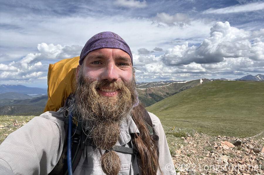
The Glacier Peak summit was only a couple hundred feet off-trail, and not that far uphill, so I took a quick detour off-trail to the summit.
After summiting, rather than backtracking, I tried to return directly to the trail moving forward. However, the trail became very indistinct, and I wound up wandering the side of the mountain for almost fifteen minutes before I returned to a clearly identifiable trail.
After dropping down to another saddle, and climbing back up to nearly the top of the ridge, alongside Whale Peak, the ridge itself began to narrow, and there was a very steep drop off on both sides.
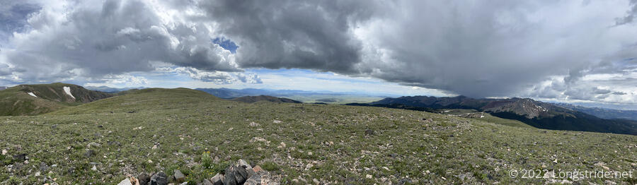
Looking west, back there way I came from, I could see the clouds darken and start to drop rain. Thunder rang out, and a light rain started to fall on me. As I continued to head east, I occasionally looked back to see the rain moving closer. I was being chased by a storm. Hail started to fall, and I put my rain jacket on.
The Whale Peak summit was not that far off-trail, maybe a little bit further than Glacier Peak was. However, with thunder and rain approaching, it didn’t seem like a good idea to take another detour. There wasn’t any tree cover, and being the highest thing around was not appealing. The thunder seemed reasonably far off so I wasn’t yet terribly worried about being on top of the ridge, but wanting to play it safe meant moving forward as quickly as possible. Which wasn’t always that quickly, when the trail seemed more of a suggestion than an actual physical thing.
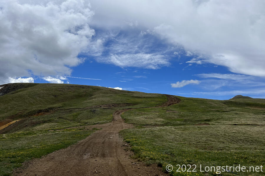
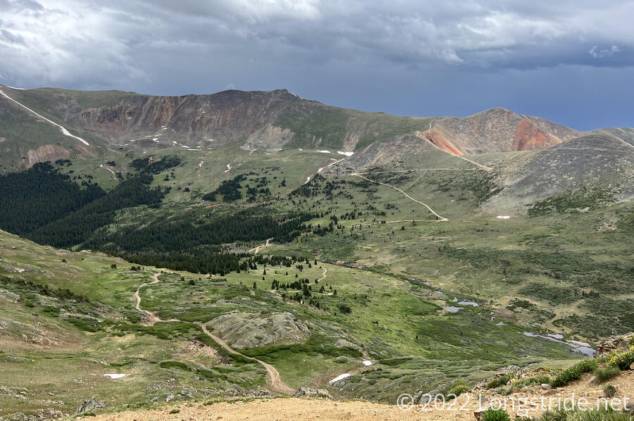
The trail (or rather, the line on my map) lead me to a rough dirt road, which I followed north for a while. At least for the moment, the rain clouds that had been chasing me now appeared to be blowing away from me. To the south, I could even see blue sky.
Up on the ridge, I actually had cell phone service. I checked the weather forecast, which said that starting in about two hours, it was going to rain for most of the rest of the afternoon. Not wanting to actually be on top of a ridge during a storm, I decided that I was most likely going to bail off the ridge and take an alternate route forward. But, since the weather was cooperating for now, I decided I would make that decision in about two miles, once I got to Webster Pass.
That plan lasted all of 15 minutes. Possibly distracted by a pair of ATVs that drove past, I missed turning off the road when the trail did. I realized that I missed my turn when I found myself on the summit of Teller Mountain, where the people in the ATVs had gotten out to take pictures. (They were impressed I was hiking to Canada, and also wanted to take a picture.)
Fortunately, I did not have to backtrack. A very rough dirt road dropped down into a valley: the same valley I would have gone into from Webster Pass. (In fact, I could see, on the other side of the valley, Webster Pass and the road from the pass switchbacking its way down.)
The hike down the road was a little slow due to the roughness of the road, and also the fact that as I got further down, the road doubled as a creek. A light rain fell occasionally on the way down, and then gradually picked up, raining continuously for over an hour.
Past the junction with the Webster Pass Road, the road gradually became better maintained and easier to walk down. A couple of cars passed me going in either direction. A pickup truck, going in my direction, offered me a ride. (I declined.)
I passed through the tiny town of Montezuma, which appeared to only have homes, and perhaps also rental properties, but did not appear to have either a restaurant or a store. I was hoping for the opportunity to at least go inside and get out of the rain for a little bit, but ultimately I’m glad there actually wasn’t anything. I needed the time that would’ve taken.
I walked straight through town, passing under a sign strung up over the road with a town‘s name, and a missile with the word “slow” painted on it. (The town’s main road had quite a few speed bumps, a speed limit of 5 mph, and lots of signs asking people to drive slowly. They really didn’t want anyone driving fast down the dirt road.) Past the sign, the road became paved.
I followed the paved road for awhile, until it reached a trailhead and turned into a dirt road re-entering the White River National Forest. Shortly after the rain finally stopped, I took a break on a small open area just below the road. The sun came out, at least for a while. I tried to dry out my wet clothes and rain jacket (which was thoroughly soaked), but there was only so much they were going to dry in the twenty minutes I was stopped. I just barely managed to get cell service, and the weather forecast called for more rain later today, and also rain tomorrow afternoon.
Following the dirt road further, I crossed over Peru Creek. Heavily polluted from mining activities, the creek water was white, and all the rocks in the creek were bleached. It looked sick, very unhealthy.
A little further rejoined me to the CDT, which, at this point, had dropped off the ridge I would have been following. The ridge, the Argentine Spine, has an alternate that continues to follow the ridge the rest of the way to Grays Peak, but the CDT drops into the valley with Peru Creek due to the ruggedness and exposure (and lack of water) on the ridge. Tomorrow, the trail will climb back up to the ridge to go to Grays.
As the afternoon progressed, clouds started to blow in. It got colder and more humid, and the clouds descended below the top of the ridges on either side of the valley, shrouding the peaks in fog.
Following the road took me last a number of car camping sites, as well as some campsites that were closed for rehabilitation. Eventually, after passing a small creek, I found an acceptable campsite a little bit off the road.
I went and got water, then set up my tent, ranking care to stay clear of the piles of very rusted cans strewn around the campsite.
I managed to get my macaroni and cheese done before it started a light rain. Fortunately, it held off from raining harder until I was all done and inside my tent.
The rain was cold enough that it caused the condensation on the inside of the tent to actually bead up and run. So it’s likely to be very humid in the tent tonight, and more than a little cold.
Once the CDT departed from the Colorado Trail, there was a huge reduction in other people on the trail; the only other people I saw were in ATVs (or in regular cars during the Montezuma alternate). This returns somewhat of a sense of solitude to the trail, which will likely persist until I start passing CDT southbounders.
My campsite puts me just 6.3 miles from Grays Peak, but it’s going to be a long climb up to the ridge, and then a slow hike along the ridge to Grays. I set an alarm and plan to leave at 6 am tomorrow, which should hopefully get me past Grays and on the way down before noon. Tomorrow’s going to be a long, tough day, but once I’m through, it’ll be the last time I’ll be above 14,000 feet on the trail.