Today was a short day in terms of miles, but it was quite eventful in terms of trail milestones.
Today, the trail will take me to Grays Peak. At 14,270 feet, it is the high point of the CDT. Getting there involves over 4000 feet of elevation gain in about 6.5 miles from my campsite this morning, and also involves summiting Mount Edwards, at 13,817 feet. Also, the ridgewalk between Edwards and Grays has a reputation for being slow and difficult. Finally, as a bonus, Torreys Peak, three feet shorter than Grays, is only a mile away from Grays, and is easily accessible, making bagging two fourteeners in one day possible.
Anticipating a hard day, and also bad weather in the afternoon, I had set a 5 am alarm to start hiking at 6, expecting that would give me enough time to summit both fourteeners before noon.
I started hiking at 7, still a little soggy from yesterday’s rain.
I continued uphill along the road from yesterday, still with only a moderate incline. After a while, I passed a parking lot with two trucks, and then a gate blocking the road to motorized vehicles. Once past the gate, the trail started to become steeper.
The area’s mining past was on display. A couple of roads branched off from the trail to go to different mines, and off in the distance were the remnants of buildings and large mining equipment, now left to rust and deteriorate.
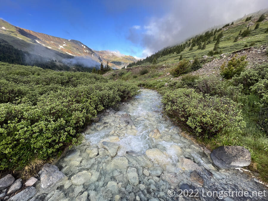
The legacy is also visible in the highly-polluted Peru Creek, which is is sickly white color that has bleached the color out of the rocks in the creek bed.
I tend to develop a bit of tunnel vision on roads, and today was no different. I overshot a trail junction by a tenth of a mile because I was concentrating on hiking up the road, and not looking out for where the trail diverged.
The trail crossed the still very sickly looking Peru Creek, and started steeply climbing out of the valley, up the face of Argentine Peak, to Argentine Pass. The CDT itself goes nowhere near the summit, but a challenging alternate, the Argentine Spine, traverses that ridge.
The trail started out initially as dirt, but as I gained altitude, it gradually became more and more rocky. There was even a very short rock scramble, a harbinger of what was to come.
The skies were mostly clear, but as the sun rose in the sky and started heating the valley, the moisture from yesterday started to rise as clouds. As I approached the pass, the wind started to pick up a little bit, and it became more humid, as the clouds in the valley escaped over the pass.
It took two and a half hours to hike the four miles from my campsite to Argentine Pass. This was a little slow, but not terrible given that included 2400 feet of elevation gain, a little more than half the gain up to Grays Peak.
At the pass were the remains of an old structure; several wooden pilings in pairs, and some wire cables. I suspected they may have been old power line towers, mostly due to there being metal power towers in the valley I hiked out of and which crossed the Argentine Spine on the other side of the pass.
I stopped for a break at the pass, since I suspected it was going to be the only good place to stop for a long while. Also, I was going to need the energy to get the rest of the way up to Edwards, still another 600 feet up.
Despite starting an hour later than I planned, I still had hope that I’d be able to at least summit Grays before noon. That would be difficult, but possible. I had two and a half miles to go, and just over two hours to do it in.
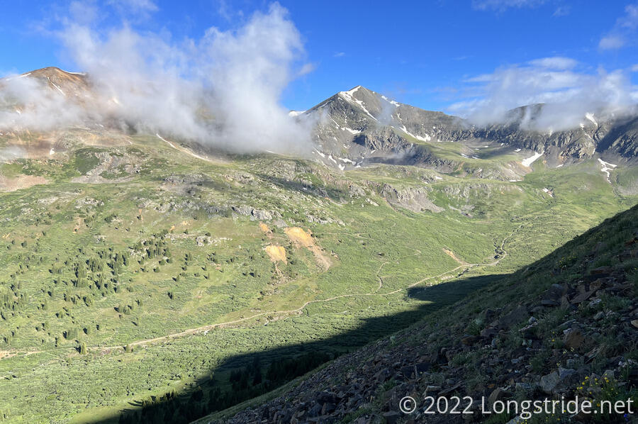
As I left the pass, heading towards the summit of Mount Edwards, the wind picked up, and the clouds still in the valley blew over the pass, eventually shrouding me in a light fog. Fortunately, there were cairns to follow. But, the humidity from the clouds and the thin air from the altitude (over 13,000 feet) made it a bit hard to breathe.
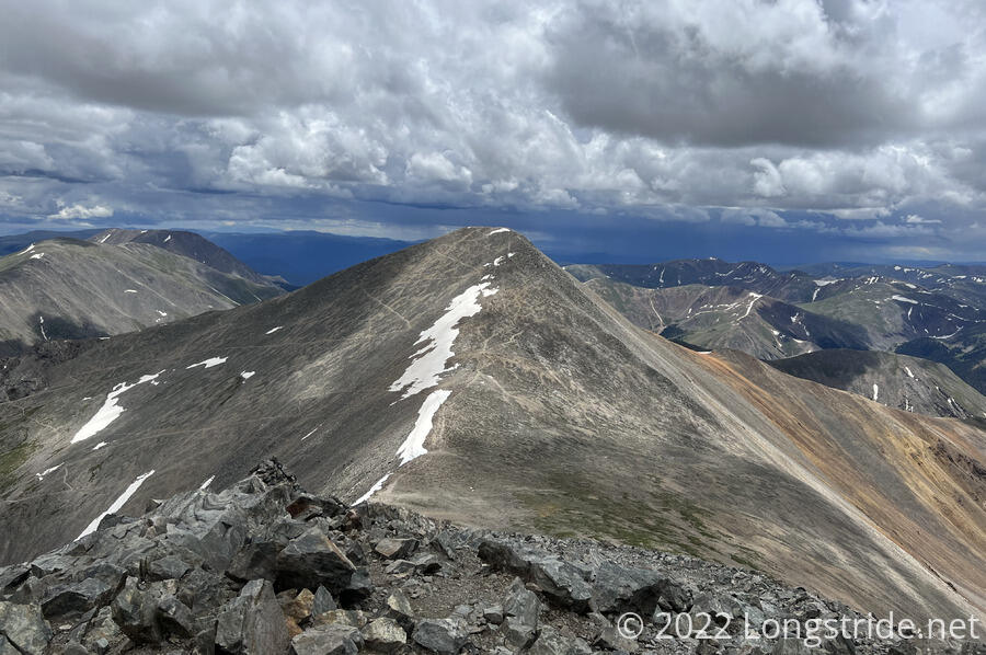
There wasn’t much of a trail to follow, besides the cairns, but it only took another half hour to reach the summit of Mount Edwards. From there, I had a good view of valleys on both sides of the mountain, as well as Grays and Torreys Peaks, still ahead.
The trail from Edwards initially descended, and then started climbing towards the narrow ridge between Edwards and Grays.
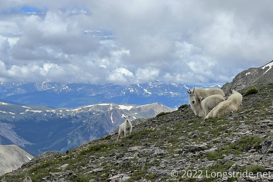
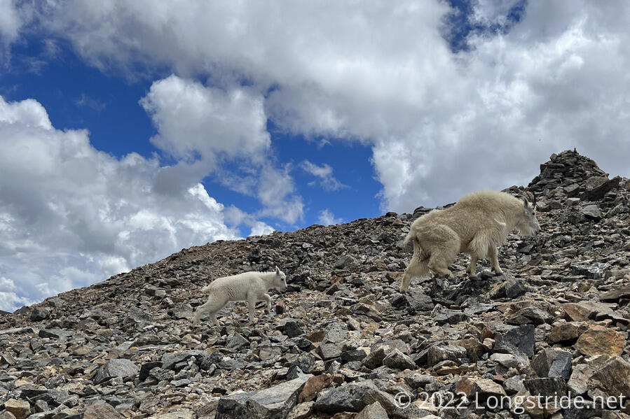
As I climbed, a herd of mountain goats appeared in front of me, several sitting directly on the trail. Fortunately, they saw me and got up and wandered away, though one of them took the opportunity to take a very long piss before strolling away.
Passing the goats, I began one of the slowest sections of trail I’ve had to date. The trail became a very rugged, rocky, narrow knife edge, often barely wider than five or ten feet across. When it was wider, it was because the trail briefly, but steeply, dropped or climbed along one side of the mountain.
Falling off the side of the mountain was a significant risk here, but I took my time, slowly making my way forward. What didn’t help was a thunderstorm brewing behind me, and I got a little bit of rain for a short while.
Eventually, I made it past the knife edge, and began a steep climb straight up the side of Grays Peak. While this was also completely exposed, at least there wasn’t a steep drop-off. By this point, the thunderstorm that had been chasing me either fizzled out, or was blown somewhere else, and I had good skies for the final climb up.
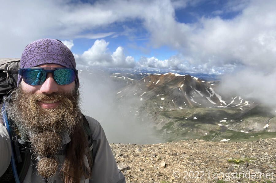
The mile and a half along the ridge from Edwards to Grays took me almost two hours, but the reward was my third fourteener, the highest point on the CDT, and great views all around.
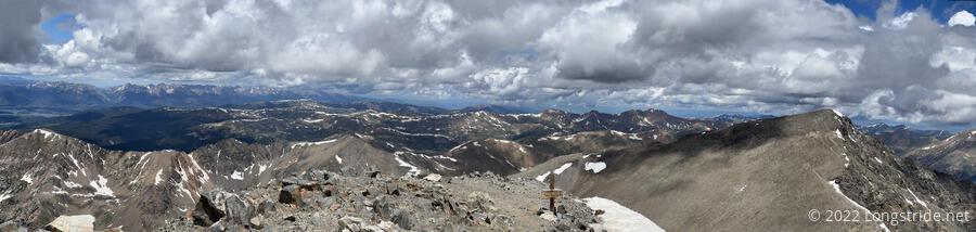
From the summit, I was able to see where I’d be hiking later today; I could actually see three people far down in the valley I’d be hiking into.
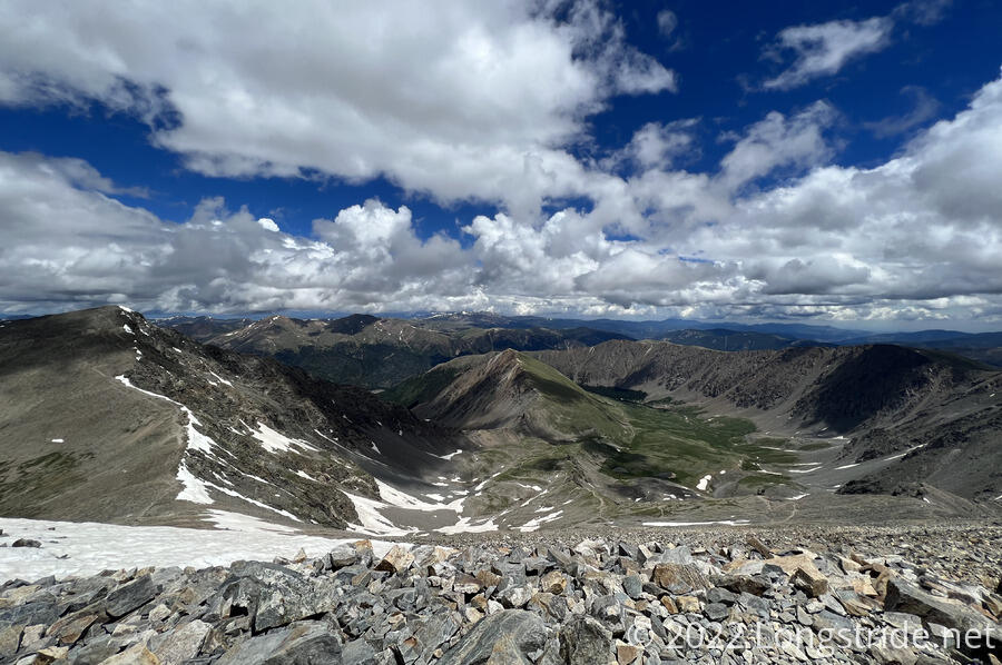
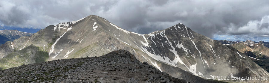
With Grays Peak sumitted, and the hardest part of the day over, I diverged from the CDT, heading down the saddle between Grays and Torreys Peaks. I planned to stop for a break just before the low point of the saddle, where a trail returned to the CDT. If the weather remained good, then I would leave my pack and hike up to summit Torreys, giving me two fourteeners in the same day.
On the way down to the saddle, I came pretty close to walking into a mom and baby mountain goat that were right on the trail. I went off-trail a short distance to give them some space.
My snack break at the saddle was uneventful, and the weather remained fine, good for a quick summit of Torreys, only three feet shorter than Grays. Since there were mountain goats in the area, I put my pack’s cover on, hoping that might slightly discourage them from messing with it (or at least make it slightly more difficult).
It took about 20 minutes to make the climb up to Torreys Peak, which had mostly the same views as Grays. However, there was a dark cloud behind Grays, which motivated me to not remain high up longer than necessary.
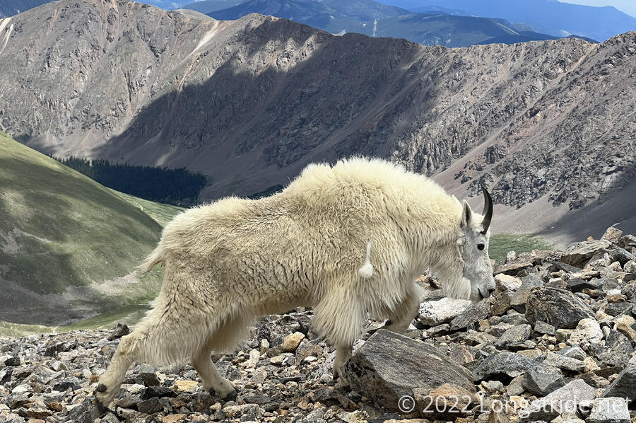
On the way back down, I passed a mountain goat with very raggedy fur, in the process of shedding off its winter coat.
When I got back to the trail junction where I left my pack, I found two adult goats and one kid nearby. They ran off as I got closer. I put my pack on and started down the trail from the saddle, a rather steep and rocky drop back to the CDT, passing over a couple of short sections of snow along the way.
On the way down, a light rain started, most likely coming from the cloud behind Grays. Fortunately, it didn’t rain for very long.
I also passed a staging area for trail maintenance. There were a few piles of logs meant for steps to reinforce the trail, and wire netting for retaining walls. There were also two bags of rocks.
The trail, as it descended, roughly followed a creek, getting closer to the creek as I hiked further down. I proceeded somewhat slowly, due to some rough and rocky ground. That, in combination from being tired from the strenuousness of the trail today caused me to lightly sprain my ankle for the first time this hike.
Further down, on the mountainside across the valley, I could see a (presumably) abandoned mine and some mining equipment.
I stopped for a snack break, keeping it very short as it started to drizzle again, though it stopped raining right after I started again.
At a trailhead, the trail began following a gravel road that paralleled the creek, lined with trees and private property. There was, however, a nice campsite large enough for half a dozen tents just off the trail, between the road and the creek. At only quarter after four, I stopped just as the rain started to pick up again. Despite it being somewhat early, the next campsite was too far ahead given how tough the rest of the day had been.
I quickly got my tent set up, aided by the shade of a tree so I didn’t get too wet. Exhausted, I took a nap for about an hour, until the rain stopped and the sun came out again.