Leaving East Glacier Park, I embarked on the final leg of my trek to Canada, as the trail took me through two incredible valleys, and over the pass between them.
The morning started off with The Austrian taking several of us to the post office. I picked up my passport, essential for entering Canada, and walked over to the general store to do my resupply while everyone else finished with the post office. Unfortunately, the general store was still closed! I expected it to open at 8, but they didn’t open until 9 — probably because everything was in the process of winding down due to Glacier’s season being over.
So I waited 20 minutes for the store to open, while The Austrian took the rest of the group back to Looking Glass, and then drove Fuck-It, Sprouts, Velveeta, and Wild Man to Two Medicine. (Recon was already long gone; since he was hiking out from East Glacier Park, he had an extra ten miles to do today.) I was kept company by three dogs who apparently liked hanging around the general store. A few other people also arrived before opening, also having not noticed the change in opening hours.
Once the store opened, I got my resupply as expected, and walked back to Looking Glass, repacked, and waited for The Austrian to return from Two Medicine to pick up me, Stumblebee, and Bass.
The Austrian dropped me off at the ranger station (so I could continue from where I started yesterday), and Stumblebee and Bass a bit further up the road at the campground (to skip some roadwalk). I passed a few cars on the road through the campground — although it had been recently closed due to bear activity, it since has reopened. One of the cars leaving the campground belonged to a friend of Fuck-It from the PCT in 2016; he was giving out donuts, which were quite tasty.
Leaving the campground via a bridge over Two Medicine Creek, I reached a junction with two trails. One, the Dawson Pass Trail, a CDT alternate, led southwest between Two Medicine Lake and Rising Wolf Mountain, eventually climbing up a glacial cirque and reconnecting with the CDT. Most of the rest of the group was taking this alternate, but I opted to stick to the CDT; the alternate is longer, and has more elevation gain, and since I didn’t really get a zero yesterday, I wanted to conserve my energy and not unnecessarily wear myself out as I approach the end of the trail.
Turning onto the Pitamakin Pass Trail (the CDT) instead, I turned northeast, circling around the east side of Rising Wolf Mountain, eventually heading up a glacial valley to the north of Rising Wolf. The trail quickly entered forest.
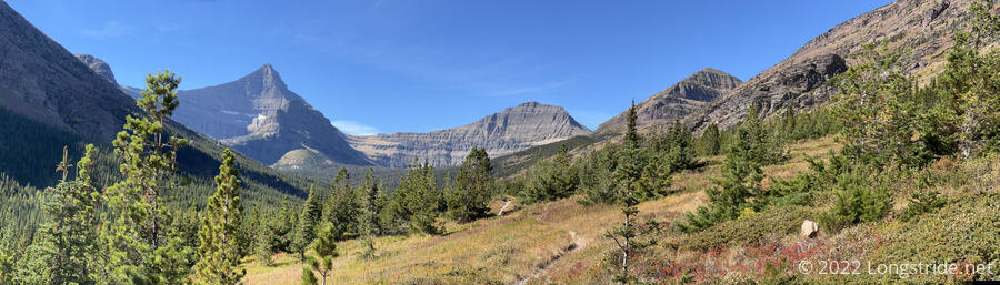
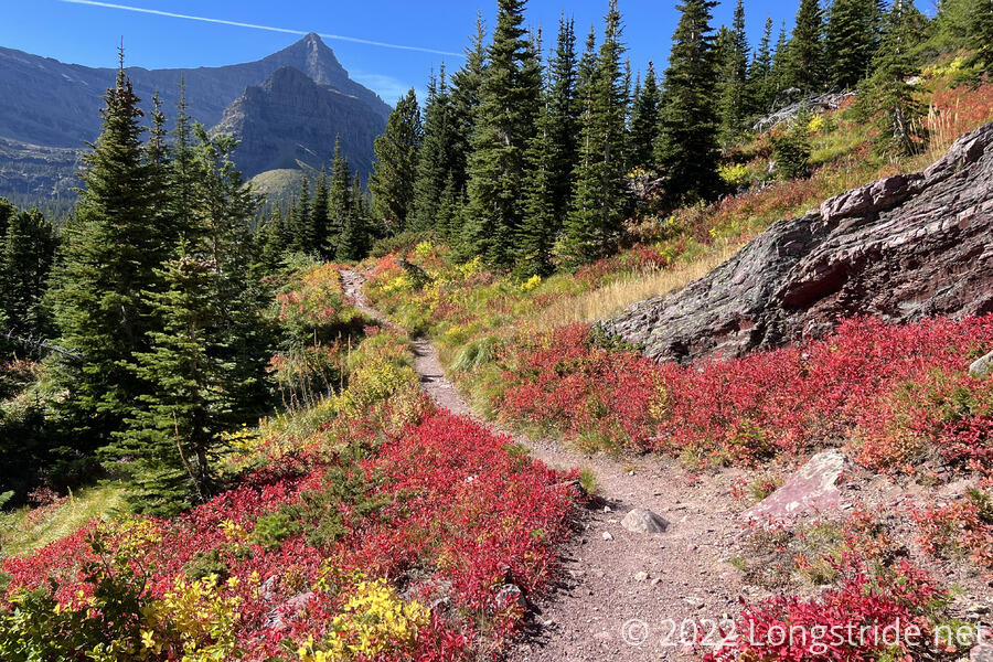
After wrapping around Rising Wolf, the trail exited the forest and crossed a valley containing a dry creek (with a simple plank bridge whose supports were exposed by the lack of water). Heading up along the side of the next mountain over, the trail headed “upstream”, climbing towards Pitamakin Pass. There was a little more forest, but it didn’t last long, and as the trail gained elevation, the forest gradually thinned. Fall color was quite prevalent, with many bushes taking on a fiery red color.
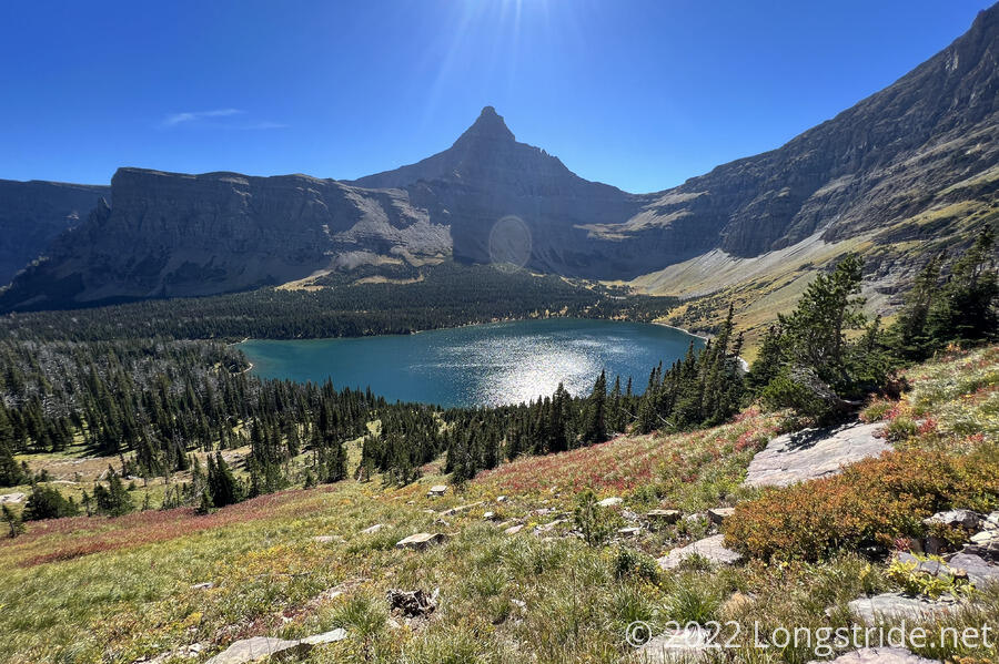
After I stopped for a short break, the forest thickened briefly, and then receded again once I passed Oldman Lake and began a steep climb up switchbacks on the narrow wall between two glacial cirques. A day hiker I passed heading back to the trailhead said that there were “a bunch of sheep hogging the trail” ahead, but they seemed to all have moved on before I encountered them.
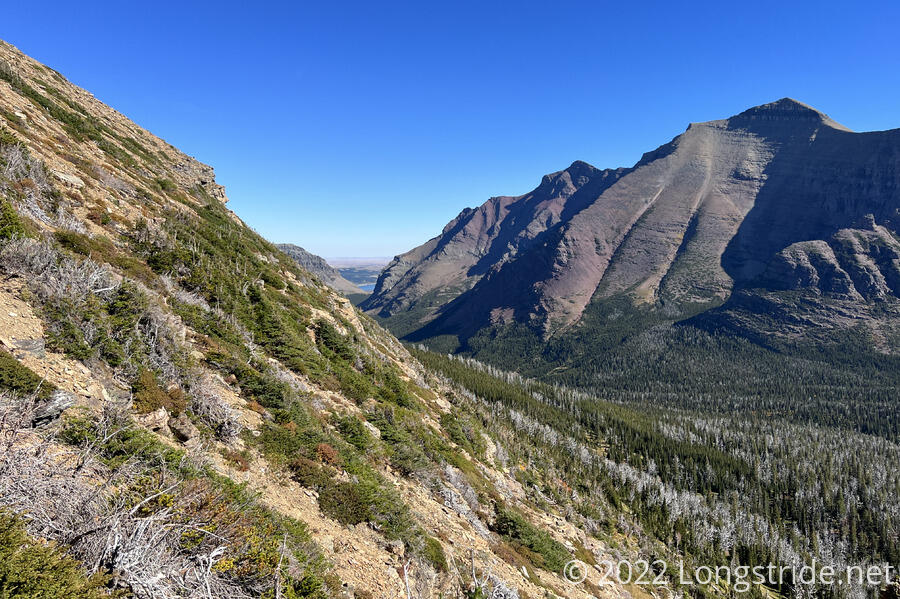
Above Oldman Lake, looking back to the east, I could see out of the valley. Lower Two Medicine Lake, and the plain beyond it, were visible through the gap between the valley’s mountainous sides.
Reaching the top of the wall brought me to Pitamakin Pass, with incredible views on both sides of the wall, to Oldman Lake on the south and several lakes to the north.
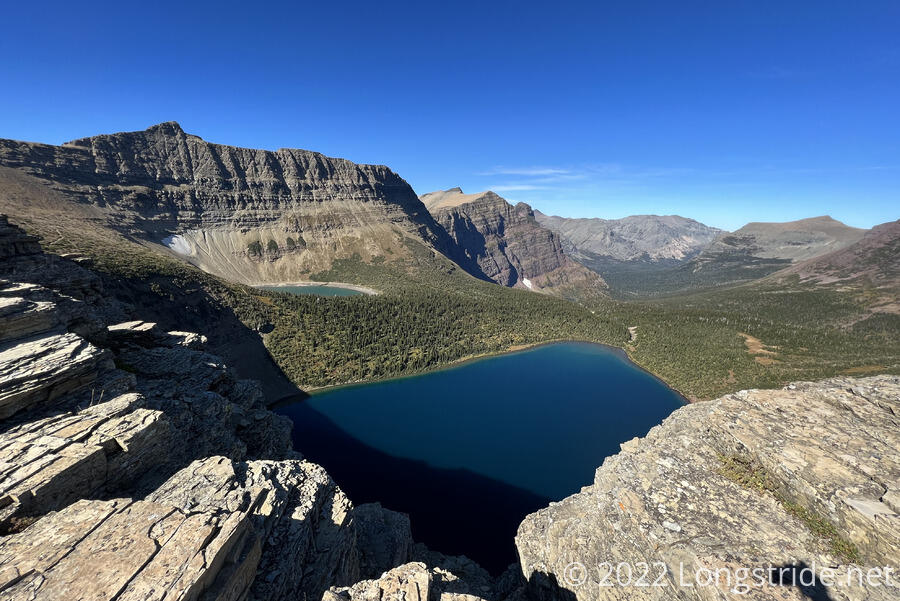
A bit unexpectedly tired and not feeling great, I took a short break at the pass to relax and take in the view, then descended into the cirque to the north, passing near Pitamakin Lake, Seven Winds of the Lake, and Morning Star Lake, as I followed the valley. I mostly paralleled the North Fork Cut Bank Creek for several miles.
Looking back uphill, after the sun dipped behind a ridge, I could see thousands of tiny white specks — insects of some kind — flitting about in the sunlight. It made the whole place seem a bit more magical and ethereal. I’d nowhere else seen landscapes quite like what I’ve seen yesterday and today, and this was still on the outskirts of Glacier: I could look back and see Lower Two Medicine Lake through the gap in the valley as I approached Pitamakin Pass, and from the pass looking north, I could almost just see out of that glacial valley. I’m expecting the views to be even better once I get further “inside” the park.
After crossing Atlatic Creek, I turned off the Pitamakin Pass Trail and onto the Triple Divide Pass Trail, starting an uphill climb towards Triple Divide Pass that I’ll complete tomorrow.
At 6 pm, a short distance uphill from the trail junction, I reached Atlantic Creek Campground, my campsite for the evening. There were two tents already there; at the food prep area, I met Tina and Rachel, two older women who’d been camping there for three days, doing day hikes along other trails in the area. They had another friend with them who’d hiked out this morning. And, they said they saw a moose last night.
Besides the campsite taken up by Tina and Rachel, there were two more campsites that the eight of us needed to squeeze into. One of them was near the stock hitching posts and the bear hang pole — similar to the ones in Yellowstone, although I felt it was a bit low. So I set my tent up at the third campsite, which was nice and flat, but still a bit cramped for four tents.
Gradually, the rest of the group arrived (with Recon expectedly arriving last, well after sunset). Fuck-It, Sprouts, Velveeta, and Wild Man had apparently seen me when I stopped for a break at Pitamakin Pass, from when they took a break higher up the mountain when approaching the CDT from the Dawson Pass Alternate. (They’d tried yelling to me, but I didn’t hear them.) They, as well as Stumblebee and Sprouts, saw a bear while on their way down into the valley from Pitamakin. I guess I’d just missed it, and wasn’t looking in the right place at the right time.
After having finished their dinner and returned to their campsite, Tina and Rachel came back to say they saw a moose go past the uphill campsites and down towards the privy. So it seems we have several large animals hanging around in the area.
Tomorrow’s going to be a long day, just under 25 miles to Reynolds Creek Campground; one steep climb in the morning to Triple Divide Pass, followed by an initially steep descent that levels out to a relatively gentle, but very long hike down a valley and around a lake.