Bed and Breakfasts usually have pretty good breakfasts, and The Old Stagecoach Inn was no exception. My only regret is that I did not take full advantage of the all-you-can-eat aspect of breakfast and order more food, but I did have a nice plate of apple pancakes, scrambled eggs, and bacon. The B&B's owner, John, was able to give me a ride back to the trailhead, but not until 10 am, so I had a relatively lazy morning before then.
From the US 2 trailhead, the trail continued down the grassy area between US 2 and I-89, and then turned onto a road that headed uphill. Since it was now fairly late in the morning, and pretty hot out, the road walk was fairly unpleasant, and I started sweating immediately. By the time I was back under tree cover, my shirt was completely soaked through.
This was a relatively new section of trail, made possible by the Winooski River Footbridge and its accompanying trail re-route, and while it was fairly steep at times as it climbed up to the ridge leading to Bolton Mountain, it was a very easy trail to hike. Once in the woods, though, it didn't take long for the gnats to find me, and they spent a good portion of the morning annoyingly flitting around my head.
In the late morning, I passed by a guy who was hiking with his large fluffy white dog. This was only notable because it was the first time I've passed a naked hiker; he was wearing only shoes (and maybe, socks).
With a long climb and descent still ahead of me up to Bolton Mountain, I opted to stop for a break at the trailhead to Buchanan Shelter, rather than go the 0.3 miles to the shelter itself.
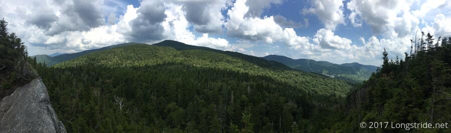
While there was a nice view of Mount Mansfield from "Harrington's View" on the way up Boston Mountain, consistent with many mountains on the Long Trail, Bolton had no view, which made it a long, unrewarding slog of a climb.
On the way down to Puffer Shelter, where I planned to stay, I stopped to chat with two guys and a dog that were hiking to Springer Mountain. Starting just a bit north of here, at VT 108 (Smuggler's Notch, which my fingers consistently want to type as "Snuggler's Notch", which sounds a lot more fun), they plan to hike the Long Trail south to Maine Junction, and then continue talking the Appalachian Trail to its southern terminus. They were happy to give away some chocolate protein bars; they were loaded down with ten days of food (!) — so much so that one of them even dumped out a liter of water (in a section of trail where water wasn't terribly prevalent) to lighten the load. Afterwards, I got the impression they might be in over their heads and would have offered them some suggestions, if I hadn't been a bit of a single-track line of thought at the moment (get to the shelter and get water and eat).
I got to Puffer Shelter around 5. While I was happy to see it had an absolutely amazing view to the east (no doubt which would make for a great sunrise tomorrow), the water source was less than desirable, and the bugs were absolutely horrible. (I briefly considered tenting in the shelter, before deciding that I didn't really want to deal with the poor water source anyway, and the tent wouldn't help me at all while I was preparing dinner. So, I decided that after a short snack break, I'd push on to Taylor Lodge, 3.4 miles away.
With Mt. Mayo in between, and then a descent into Nebraska Notch to get to the shelter, it was very much a gamble that I'd get there at any sort of reasonable time. Fortunately, the trail was fairly reasonable, and it was only the descent into the notch that slowed me down significantly; the trail was somewhat poorly marked there as well, and I went slightly off-trail twice.
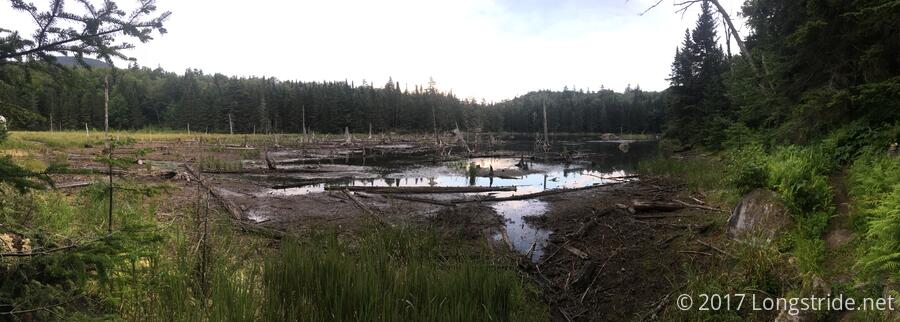
As I was descending into the notch, I got a brief glimpse at a lake, and I thought, "I must be close, that's probably attached to the water source". Instead, as I got closer to the lake's level, it became clear that it was actually a large beaver dam.
I made reasonably good time, making it to Taylor Lodge around 7:30, about two hours after I left Puffer. Taylor Lodge, named for James Taylor, who first proposed the Long Trail and founded the Green Mountain Club, is a large and relatively spacious (if dark) shelter, with two levels of bunks and a loft area behind a mesh wire door, and a seating area in front of the bunk area, underneath the loft. The shelter's water source, located a third of a mile away down a fairly easy trail, was one of the best flowing piped springs I've seen in awhile, and it made the distance needed to get there not especially onerous.
There were three other hikers at the shelter; one (Revo Ranger) on a southbound section hike, and the other two (Climber and Sidewinder) going north, completing separate northbound section hikes. Unfortunately, I didn't really get to talk much with them; with getting to the shelter so late, I was pretty much focused on getting water collected and dinner cooked and eaten. As it was, I only cooked the first half of my dinner (so no ramen) because it was so late, and I was tired.
Still, today was somewhat of a success; I went further today than I had planned, which potentially puts me in position of shaving a day off the hike, if I use that to move a shelter further than tomorrow's plan calls for, and go into town Saturday evening, instead of Sunday morning.
Tomorrow: Mount Mansfield, the highest peak in Vermont.