Tackling Mather Pass today was one of my longest and most memorable hiking sessions ever.
My alarm was set for 4, but with the cold, I was pretty sluggish until 4:30. Even though it was clearly below freezing outside, I was very pleasantly surprised to have a completely dry tent. Dry that is, except for the water that again leaked out of my pack.
Quoi and I discovered that our very wet shoes from last night froze solid overnight. They were completely inflexible, and we couldn’t get our feet in them at all. Quoi sat on her boots to warm them up; she said she felt like a chicken trying to hatch an egg.
Using the same method, I eventually got my boots to thaw enough to get them on my feet. Between trying to hatch my boots, cleaning up the water spill, and it just being cold, I didn’t leave camp until 7 am, quite a bit later than I wanted. Quoi was long gone by that point, but I fully expected to catch up with her on an uphill somewhere.
The day got off to a further inauspicious start when I slipped on some ice while trying to avoid walking on a bit of snow. I pretty much knew I was going to slip on the ice immediately before I stepped on it (and the snow I was trying to avoid wasn’t particularly deep or wide), and as expected, I went down hard, falling on my left shoulder.
I bounced back up like I usually do, but my arm hurt and felt pretty weak for a while from the impact. That slowed me a bit, as it reduced the force I was able (or willing) to apply with my trekking poles in that arm. I tried to rest it some by not using a pole with that arm, which worked to an extent since by that time, I was mostly out of the snow and going through a forested and not very rugged trail, but it was still awkward to hike that way.
After a cold, wet, and slippery creek crossing, I took a short break, ostensibly to rest my shoulder, but also to wring the water out of my socks, Alias, Tenderfoot, and two other hikers with them came past. I had thought they left Bishop the day before we did and were ahead, but, apparently they weren’t. They went on a bit while I finished putting my shoes on, and then I caught up with them a short while later after they (and I) had gotten off the trail and were wandering around in the woods. (We weren’t wandering aimlessly, of course, thanks to gps-enabled maps, but I hadn’t been expecting to bushwhack through the woods when there was no significant snow on the ground.)
The next major obstacle of the day was the South Fork Kings River. A fairly large body of water in the early season, two hikers died attempting the crossing last year. A side trail that parallels the river and follows it upstream exists (though is not mentioned in my trail guide), though the trail is unmaintained. I knew of it because Quoi (and later, Alias) mentioned its existence. Conveniently, a giant arrow drawn on the ground at the intersection pointed the way to the side trail, so that made it easy to find and follow initially.
However, the trail disappeared every now and then, especially when it went over rocky areas, making it somewhat difficult to follow at times. I was also missing one critical detail: how long I should be following the trail for. Looking at maps, it seemed like one could keep going north until completely passing the river, and then cutting west to rejoin the PCT.
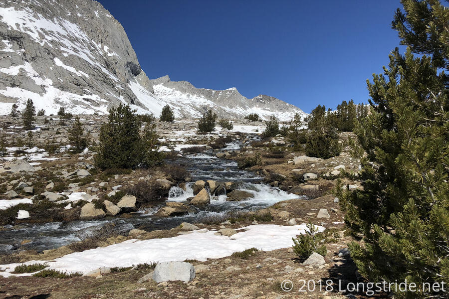
When the side trail disappeared, it wasn’t that difficult to make forward progress: just follow the river. Occasionally, I’d find someone else’s footprints, or see the trail. After a bit more than a mile, though, I was getting a bit frustrated with the side trail continuously disappearing (not to mention, still not knowing how long I should be following it for), and I decided to cross the (now somewhat significantly smaller, though still fast-moving) river, before the PCT (which was visible) took a turn to the west. (The likelihood of snow fields as I traveled further uphill also factored into my decision; the last thing I wanted to do was try to navigate using only maps along a side trail along a river as the PCT got gradually further away.)
I crossed, getting my knees wet, and then perched up on a rock next to the trail to dry out my socks and shoes. This wound up being a big waste of time (especially since I didn’t do anything else productive, like, eat some snacks), since my feet were just going to get wet again later. After I continued following the PCT uphill, I saw Alias and his group across the river, until the PCT turned west and I lost sight of them.
I stopped to take a snack break about a mile later, at a large, relatively flat, rocky area, and got one boot off, only to realize that I was stopping just short of a stream crossing that, by the sound of it, would likely get my feet wet. So, I put my boot back on, crossed the creek (and got my feet wet), and then took a break at the next flat area.
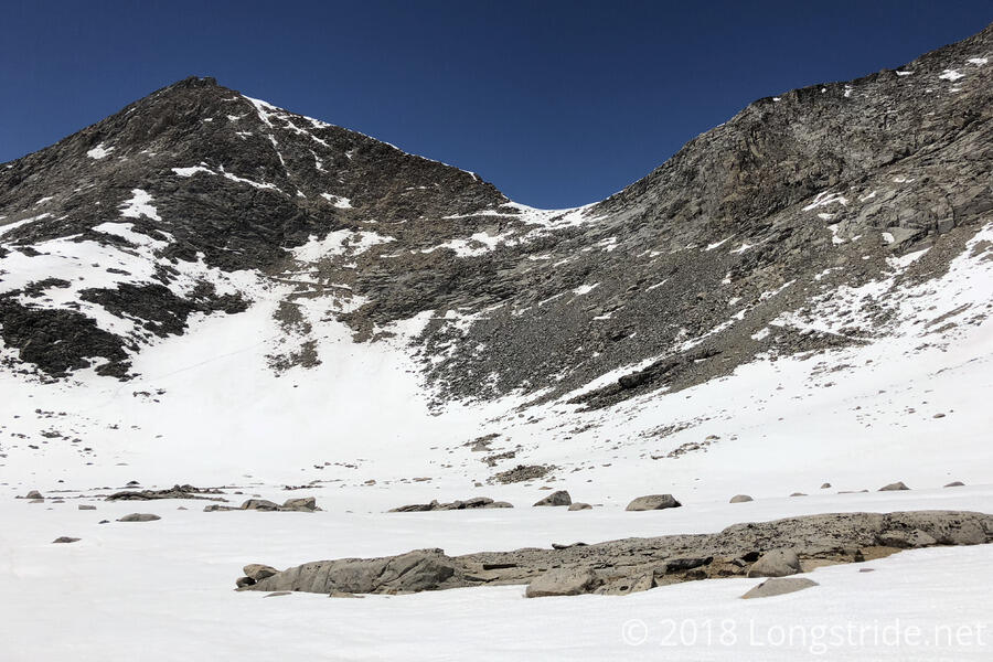
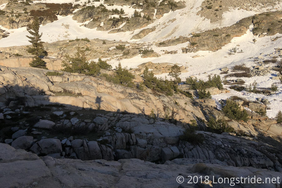
Before much longer, the patchy snow that had been gradually increasing turned into a snow field that extended the rest of the way to the pass. As I began to cross it, still before noon, I got the distinct feeling I had gotten there an hour late. I wasn’t postholing on every step, but I probably would have been if there hadn’t been other footsteps to follow.
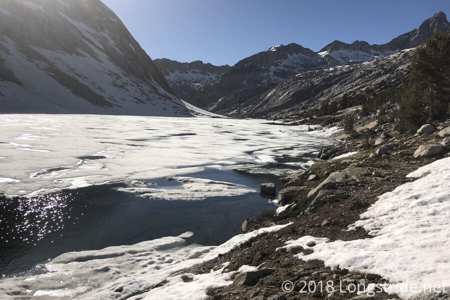
It was very slow going, as I followed footsteps from rock island to rock island, and I lost sight of the trail of footsteps a couple of times, occasionally having to backtrack until I regained the trail. At one point, on a rock island between two frozen lakes, the footstep trail seemed to completely disappear, with no footsteps going anywhere in the general direction of the trail.
Eventually, I spotted a faint view of footsteps in the general area the trail should be, further up the mountain off in the distance, and I blazed my own path to the trail. Roughly from where I lost the footstep trail, as the PCT approached Mather Pass, it curved along the edge of a large bowl, gradually gaining altitude until it began a series of switchbacks to reach the pass. It was slow progress, but it could have been much worse. I did not posthole much in this area, despite the warm temperature and the afternoon sun. Once I got far enough along to have a view of the pass itself, I realized why I hadn’t been able to find footsteps: everyone else had cut out that entire curve, instead making a beeline for the switchbacks, charging directly up the side of the mountain (and quite steeply too).
As I got to the switchbacks going to the pass, the trail became quite sketchy. About half of the trail was exposed; the other half was snow-covered, but with easy-to-follow footsteps. Eventually, the footsteps stopped entirely, and a wall of snow covering the trail blocked my progress. Looking around, I came to the conclusion that the only way forward was up: cut the switchback via some rock climbing. And as I looked around a bit more, it became clear I wasn’t the only person to reach that conclusion: there were someone else’s footsteps in the dirt going up the mountain.
I had to repeat this a few times, and I’m sure I did future hikers (and trail maintainers) no favors by knocking down dirt and small rocks, but, short of being able to walk on top of melting snow, that was the only way forward.
I reached Mather Pass around 3:15 pm. Rather, I reached just short of the pass, and continued to follow most everyone else’s footsteps as they cut the final short climb to the actual pass and went down the north side of the mountain early.
As I hiked down the mountain, following footsteps and postholes, I found a water bottle lying in the middle of someone’s glissade track. Feeling a little guilty about not picking up Quoi’s sock yesterday when I came across it, I picked up the water bottle, and put it in my pack’s ice axe loop, the only place I had available to put anything.
As I continued to follow the postholes, I lost my balance stepping into one, and fell, hanging not quite upside down along a slope, with my foot stuck in the snow. This strongly reinforced my desire to not be snow hiking alone, but since I was alone, I was going to have to get myself out of the slightly precarious situation I was in.
Probably the best thing to do would had been to take off my pack so it wasn’t a deadweight pulling me downhill, but I wasn’t quite ready to do that: it would have likely gone sliding down the mountain uncontrollably, probably much further than I’d have wanted it to go, and I’d have to waste time chasing it down. So while that was an option, I wasn’t quite ready to do that yet.
I dug my foot out of the hole, which initially only served to rotate me further to a completely upside-down position, and at that point, I knew that I was going to be sliding down the hill regardless of how I got myself out. I finally got my foot out of the hole, and down the hill I went, though I managed to turn myself to be right-side-up and sliding feet-first down the hill, and stopped in a slightly bowl-shaped depression near where some other people had glissaded.
Now that my pants were wet from sliding down the snow, and with the hour growing ever later and a campsite still many miles away, I did two more short glissades down the mountain to save time, and continued to follow the foot trail, which wasn’t anywhere near where the PCT itself actually was.
The PCT here followed the side of a mountain, roughly 200 feet above a partially frozen lake in the valley between two mountains, and slightly above a small forest between the lake and the trail. But, the foot trail I had been following was somewhat lower than the elevation of the trail, and I entered the forest roughly 80 - 100 feet below the trail.
The snow thinned, turning into blotchy snow islands in the forest, which made following a foot trail much more difficult. I kept kept finding and losing the footstep trail, and resorted to trying to keep a relatively constant elevation as I hiked parallel to the PCT, expecting I would eventually intersect the trail in a mile or two when it started to lower its elevation. Pretty tired, I stopped for a snack break about 5:30 after losing the trail again.
As I was hiking through the forest, It was somewhat reassuring to randomly stumble across footsteps in the snow; I wasn’t the only person going through there. And while I could have “easily” hit the PCT by simply going uphill, I was pretty tired and didn’t want to waste energy climbing a hill I’d just have descend anyway. (Also, the trail appeared to have been covered in snow, and I didn’t want to climb up to a snowy trail; that wouldn’t have been an improvement in the situation.) Eventually, after navigating around a steep rock slope with a creek running over it, I hit the PCT quite a bit sooner than expected, and it was largely clear of snow.
For the next while, the trail was largely clear, with occasional snow patches, and it was easy to follow. However, it also passed by numerous flooded creeks and waterfalls, and the trail itself was often flooded. My feet continually got wet, but it was still warm out, and as long as I kept moving, they would slowly dry out.
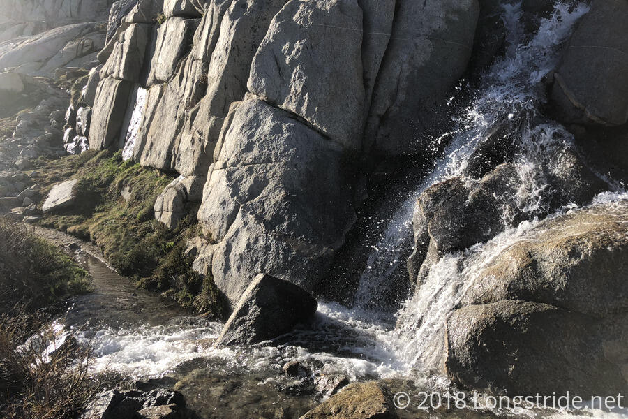
The trail had a relatively gentle slope for awhile, before beginning a roughly two mile steep descent down a series of very rocky switchbacks. (Quoi says this is called the “Golden Staircase”; and while it was clearly a great engineering project, for me, they were the worst possible switchbacks, being steep, windy, and very rocky and hard on the feet.) At times, it paralleled Palisade Creek, which was a thundering waterfall dropping down the mountain much faster than the trail was.
The sun dipped behind the mountain as I made my way down the “staircase”, and I was pretty tired. And while there were a few campsites near the trail (and plenty of water; there was at least one water drainage that cut across several switchbacks of the trail before being funneled towards Palisade Creek), they were all tiny and rocky, and I wouldn’t be able to get my tent set up there.
For awhile, the glow of the sky was enough to see by, but as the trail continued to descend the mountain, it entered into a thick pine forest, blotting out the sky, and I had to get my headlamp out. For another hour or so, I hiked through the dark forest in search of a campsite (preferably, whichever one Quoi was at; I had a vague idea of where she’d be if she went as far as she planned, but we never really discussed where we’d stop today because we expected I’d have caught up with her long ago).
The forest had quite a number of stream crossings, many of which were swollen past the point of being able to easily rock hop and stay dry. Each time I thought I might arrive at a campsite with vaguely dry feet, another creek appeared, or the trail itself was completely flooded with water. A few stream crossings were pretty sketchy to cross at night with only a headlamp for illumination, but, I took my time and made it across each one.
As I grew more tired, I started looking for campsites in earnest, passing by a few when I couldn’t, with the light of my headlamp, figure out where the tentsites were. Finally, around 9:30, at the last campsite I was considering, I saw the glow of a headlamp in a tent, and I headed towards it. As I approached, a voice called out, “Who’s that?”. It was Quoi, who was very much relieved that I had finally caught up, and to also not have to camp alone! She’d gotten there an hour earlier (and I had suspected for awhile that she had not been too far ahead of me; on the staircase, I had seen wet footprints that I thought were hers).
We caught up with the day's events, but I was pretty exhausted, and I quickly turned to setting up my tent. Too tired to cook (and it being well past hiker midnight), I didn’t even have snacks for dinner, opting to get to sleep as soon as possible.
Quoi, it turned out, had her own set of frustrations through the day, and wound up descending the mountain too quickly, winding up at lake-level. So, for a short distance, she actually walked through the partially-frozen lake, something I was very much trying to avoid myself.
The water bottle I found didn’t belong to Quoi, but she had found it and picked it up, only to have it fall out of her pack because she had no way to secure it at all. So I was slightly disappointed there, but at least I picked up a (large) piece of trash from the trail. Though, that means I’m stuck with it for quite a while, until we get to Mammoth Lakes.
Tomorrow: Because a 14.5 hour day of hiking to make it 15.2 miles down the trail wasn’t enough, get up early and make it over Muir Pass.