Although we were a little sluggish in breaking camp this morning, CareFree and I set out from the campground at 7, heading towards Holden, and from there, Stehekin, making it to town when we needed, but only just.
The morning started out foggy, but improved to merely overcast after sunrise. To Holden, the trail largely followed a dirt road. Only about a tenth of a mile wide, we quickly passed through the village, cutting past two cabins to join the Tenmile Falls trail, heading east. The trail, leading to a waterfall on Tenmile Creek, was quite well maintained, manicured with stone borders, and was a very easy hike to the falls.
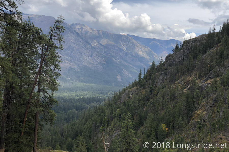
Along the way, on the side of the mountain on the south side of the valley, a portion of the mountain was deforested below a creek. it wasn’t clear what the purpose was; it looked like the creek had been diverted, possibly to control flooding and erosion. But there also used to be a large copper mine in the area, and this may have been part of the mine remediation efforts.
Tenmile Falls itself was small, and was the end of easy hiking for the day. At the falls, the trail turned north on the Tenmile Creek Trail, climbing a very steep set of rocky switchbacks into a burn area. After first diverting away from the Tenmile Creek as it climbed the switchbacks, after a mile or so, the Tenmile Creek Trail veered back towards the creek, paralleling it as it climbed up the middle of a glacial valley.
About five miles into the day, after crossing Tenmile Creek, and joining the Company Creek Trail, we stopped for a short break. The burn area and lack of flat ground made finding a good place to rest somewhat difficult, and we eventually just stopped somewhere we could sit without getting burnt tree debris all over us.
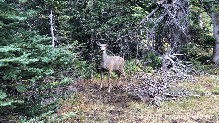
As we continued up the valley, we were lucky to see a deer standing out in the open. As we got closer to the head of the valley, we also started hearing warning cries from marmots, though we never actually saw any of them.
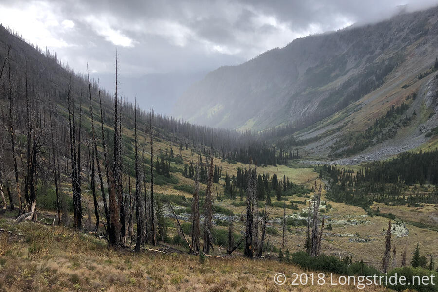
The head of the valley had a steep wall, connecting the two mountain ranges forming the sides of the valley, and also separating the south side of the valley from the north side. A steep set of switchbacks climbed up the south side of the wall, to Hilgard Pass. From the pass, an incredibly steep set of switchbacks led down the wall, to the valley floor.
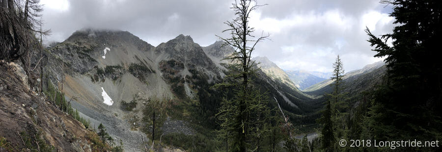
Hilgard Pass provided a great view of both sides of the valley, but the trail quickly descended into forest, and the view disappeared. Once in the forest, plants overgrew the trail, making for a somewhat annoying hike. At least it was dry, so they were only a minor nuisance, and we made reasonably good time on the gradual downhill through the valley, stopping for a break on the side of the trail, roughly 11.5 miles in. We kept this break as short as possible — only about 15 minutes — because we still had almost seven miles to go, and less than three hours to do it in. The climb up to the pass, and the first part of the climb down was slow, taking longer than I had expected, and inasmuch as I had a schedule for the day, it felt like we were behind, since we’d have to maintain over 2.5 miles/hour with no further breaks.
Once we continued after the break, it seemed like this wouldn’t be too difficult, but about two miles later, we came to a crossing of Company Creek. We had crossed the creek several times further up the valley, where it was not very substantial. Now, though, it was wide and fast-flowing, and we needed to find a way across.
The trail itself crossed directly through the creek, and it looked from footprints on the bank that other hikers had done that already. However, since we were in a bit of a rush, we didn’t want to take the time to stop and take off our boots to cross, so we had to find another route. Fortunately, with the assistance of another hiker, we found a crossing shortly downstream, a massive tangle of downed trees.
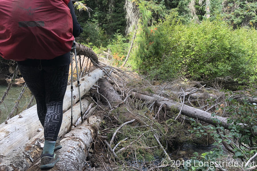
If we weren’t on such a time crunch, I don’t think we would have crossed the log bridge, which required some creative scrambling, but we didn’t have time for delays, and I knew that if my feet got wet, it would be unlikely I’d be able to keep up the pace we needed to make it to the road before the next bus.
Once on the other side of the creek, the trail flattened out a little. From somewhere, I found the energy to generate a significant burst of speed, and we practically ran down the valley. A light rain began to fall, on and off. Even though we were getting wet, we couldn’t stop. My legs felt like they were on fire, as though I was borrowing from tomorrow to speed through today.
Reaching the Company Creek Trail trailhead just after 3 pm gave us about 20 minutes to make it about a mile to Harlequin Bridge and Stehekin Road, where we could catch a bus into town. Four times a day, a bus runs from Stehekin ten miles up the road to High Bridge (where the PCT crosses) and back. Harlequin Bridge is about four miles from Stehekin, so while it wouldn’t be the worst thing in the world if we missed the bus, we’d get to town much later than we wanted.
We power-walked down Company Creek Road, passing by a PCT Hiker Camp that was not otherwise mentioned anywhere, especially including on the PCTA’s website with details on the fire closure. Just before we made it to the bridge, we saw the bus pull up, and we began running to catch the bus; fortunately, even if the bus driver hadn’t seen us running, there were a few other hikers already waiting there that let us catch up to the bus before it could pull away. This was especially helpful, since the bus was actually about five minutes early!
The bus made one stop on its way to Stehekin, at the Stehekin Pastry Company. There, the bus waited long enough for everyone to get food from the bakery, which, by reputation, is excellent. Quite a few other hikers were hanging out at the picnic tables outside the bakery, including Caveman, who took the shuttle from Holden to Lucerne, on Lake Chelan, and then came to Stehekin via the ferry, which runs the length of the lake, from Chelan to Stehekin.
I picked up a sandwich and soda from the bakery, both of which I had finished consuming by the time the bus reached Stehekin, and dropped us off in front of the post office. It took us awhile to get our resupply packages, partly because there was only one employee, and also because the office was practically overflowing with hiker packages, and it took awhile to retrieve boxes. I also picked up my passport and Canada Entry Permit, which a friend sent after I got to Snoqualmie Pass. This is my 26th, and final, resupply for the trail. (Also the 12th sent by mail.)
From the post office, we went to North Cascades Lodge at Stehekin to check in to our room. Once we finished, I looked over to see a hiker I hadn’t seen since Tehachapi: Sparky! Sparky, and Ghost Hiker (who was outside) had left Tehachapi a day before me, and then skipped around on the trail due to taking some time off as a result of an injury within their group, and this was the first time we’d been in the same place in over four months. They invited us to join their group for dinner, and we happily accepted.
Pretty tired, we decided we wanted to zero at Stehekin to give our legs a rest and mentally reset after eight days in a row of rain. (CareFree and I both had this idea while we were getting snowed on, though we didn’t actually say anything about it until two days ago.) Unfortunately, not only was the Lodge full for tomorrow night, but there was already a waitlist, little chance of cancellations, and even if there were cancellations, we’d be unlikely to know of them until 4:30 pm tomorrow, which somewhat defeats the purpose of taking a zero to rest during the day. We put out names on the waitlist (with two other people ahead). With lousy weather forecast for tomorrow, there was a chance we’d get lucky, but as expensive as the rooms are here, it wouldn’t be the worst thing to not stay here an extra day.
Now armed with room keys, we retreated to our room and proceeded to drape all of our wet sleeping bags, socks, and tent components over all available surfaces — chairs, tables, and the dresser — to dry out. Ideally, we would have done laundry, but as in Skykomish, the lodge didn’t have a guest laundry, and the public laundry was further away from the lodge than we wanted to deal with. So instead of clean fluffy socks, we’ll wind up with crusty (but still dry) socks to carry us the rest of the way to Canada.
After a much-needed hot shower, we got some disappointing news: CareFree’s application for her Canada Entry Permit had not yet been approved. With today being a Friday, it now seemed unlikely that she’d get an approved permit in time. While it still seemed likely it’d be approved before we got to Canada, Stehekin would be the last internet access we’d have until actually getting to Canada, which means that if it is approved, she wouldn’t be able to receive notification of that.
This wound up becoming a point of conversation at dinner with Sparky, Ghost Hiker, and their current hiking companions, Mugshot and Villain, and the wider conversation made one of them, a US citizen who had an entry permit but no passport, suddenly realize they had a problem they didn’t know about. (A passport or enhanced drivers license is necessary to re-enter the US, and they didn’t have one.)
Dinner at the restaurant was somewhat slow, and we weren’t back in our room until relatively late. Afterwards, CareFree and I briefly mulled our options for tomorrow. We ultimately decided that we’d get up to get breakfast around 8, and then clear out of our room and figure out the rest of tomorrow’s plan afterwards, once we see how we’re feeling tomorrow.