With epic views to ring in the new year, we made our way across the Tongariro Alpine Crossing.
We got up at 5:30, and walked from our cabin towards the entrance to the holiday park. There were still clouds, and we couldn’t see the mountains, but we could see some clear sky in the direction they were in.
We finished packing, ate breakfast, and by 7 am, CareFree and I were on our way towards Tongariro National Park, along with Hannah. (Peter and Susana had left a few minutes earlier.) We just had an hour and a half of road walk first to get there. A faint rainbow as we left the holiday park seemed a good omen.
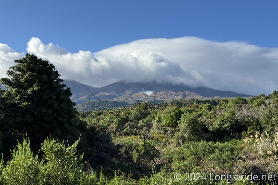
It was bright and sunny out, though clouds still congregated around the mountains. With the clouds racing in the wind, we didn’t think it would be too long before we started to get good views. Mount Tongariro’s top was still hidden in the clouds, but we could see the mountain now. As we proceeded down the road, the clouds slowly lifted as they raced by, and the mountain became more and more visible. One of its vents was clearly emitting steam — Tongariro is still an active volcano.
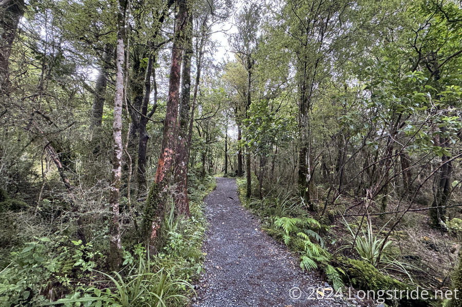
We turned off the highway onto a gravel road that entered Tongariro National Park, and eventually made it to the trailhead. The whole time since leaving the holiday park, we’d been going slightly uphill. Entering the forest to begin the Tongariro Alpine Crossing started a steep climb that would mostly last until we were as high as the trail would take us today.
Hiking the TA southbound, we were going against the flow; the Crossing is usually (and intended to be) hiked starting at its other end, because there’s less elevation gain (350 meters) if you head north. Fortunately for us, the official recommendation was to not hike the Crossing today because of chance of high wind gusts and low visibility. As a result, the shuttles that normally run between National Park Village and the parking lots on either end weren’t running today, so we wouldn’t have to worry about passing the usual 1000-2000 day hikers on the trail.
The forest was much like other North Island forests, except this time, the trail tread was very nice gravel with a stabilizing mesh underneath. (Of course, being a very popular trail, it was built to a much higher standard.)
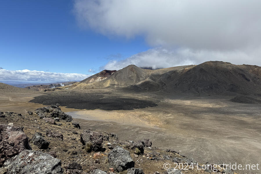
A few displays on our way up reminded us we were in an active volcanic area. Part of the trail went through a lahar zone (heavy rain could trigger a mudslide of volcanic debris). Further up, we passed small craters from ballistic debris thrown out from recent eruptions. A pair of pit toilets stood at the site of a former overnight hut, which was badly damaged in an eruption in August 2012, and subsequently removed.
As we climbed, the wind picked up and it got colder. I put on my rain jacket to stay warm, and put on my pack’s rain cover because it started to drizzle a bit. It didn’t rain for very long, so it wasn’t really necessary, especially since it blew off in the high winds. I didn’t notice that until we stopped for a break, so now I don’t have a pack cover, and (of course) there’s rain forecast before I’ll likely have the opportunity to get a new one.
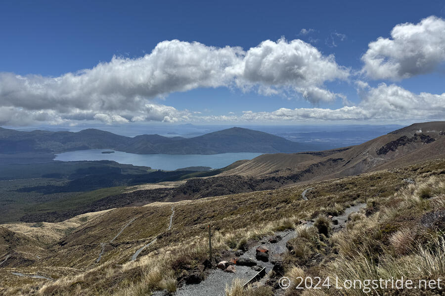
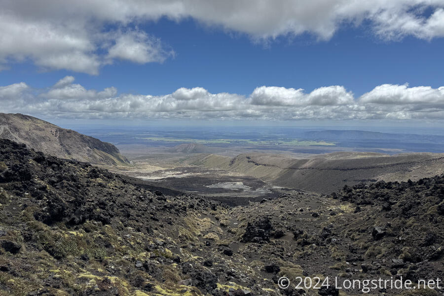
Heading uphill, we got increasingly good views of Lake Rotoaira and Lake Taupō (the largest lake in New Zealand), to the north.
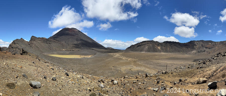
Crossing over the top of our first climb, just after another set of pit toilets, brought us into the Central Crater area, where it became very windy. Blue Lake became visible, a beautiful jewel in a rocky, desolate area.
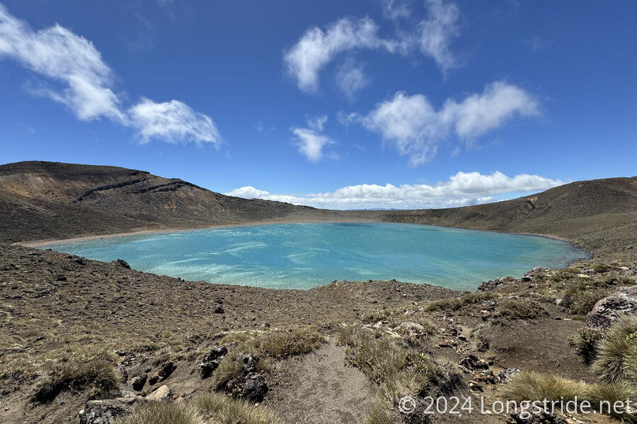
Dropping down from Blue Lake (which was easier said than done, because it was extremely windy on the ridge above the lake), we crossed a wide plateau in the Central Crater.
Beyond were three blue-green lakes, the Emerald Lakes. CareFree, Hannah, and I stopped for a break there, before starting the final steep climb up Red Crater. A very large sea gull landed nearby, seemingly waiting for people to feed it. A group of half a dozen tourists did.
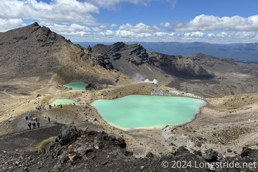
From the lakes, the trail has a short, but steep, climb up to the top of Red Crater. This is where we rain into the most people. We’d passed some before we got to Blue Lake, on their way down. We passed several more people taking a break above Blue Lake, and some more between Blue and Emerald Lakes, but the bulk of the people we passed were during the climb to the summit.
Fortunately, there weren’t that many people hiking the crossing (because of the official guidance for the day), or we would have had a bad time going against the grain. As it was, the climb was already pretty difficult as it was, and trying to avoid hundreds or thousands of tourists would have been very frustrating.
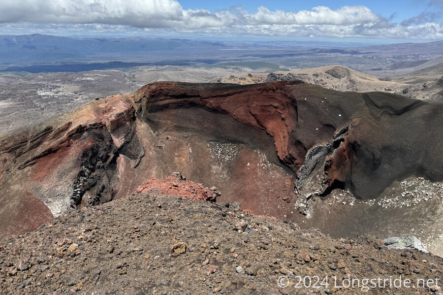
The high point of the rim of Red Crater is the high point of the Tongariro Alpine Crossing. We had good views of the surrounding area (less Ngāuruhoe, whose top half was still in a cloud, and Ruapehu, which we got a brief glimpse of on the way to the Emerald Lakes).
Descending from Red Crater, just as steep but a little longer, brought us to South Crater. A trail cut straight through the middle of the crater; Peter suggested it looked like a hiker highway. If there had been the normal number of hikers today, it definitely would have.
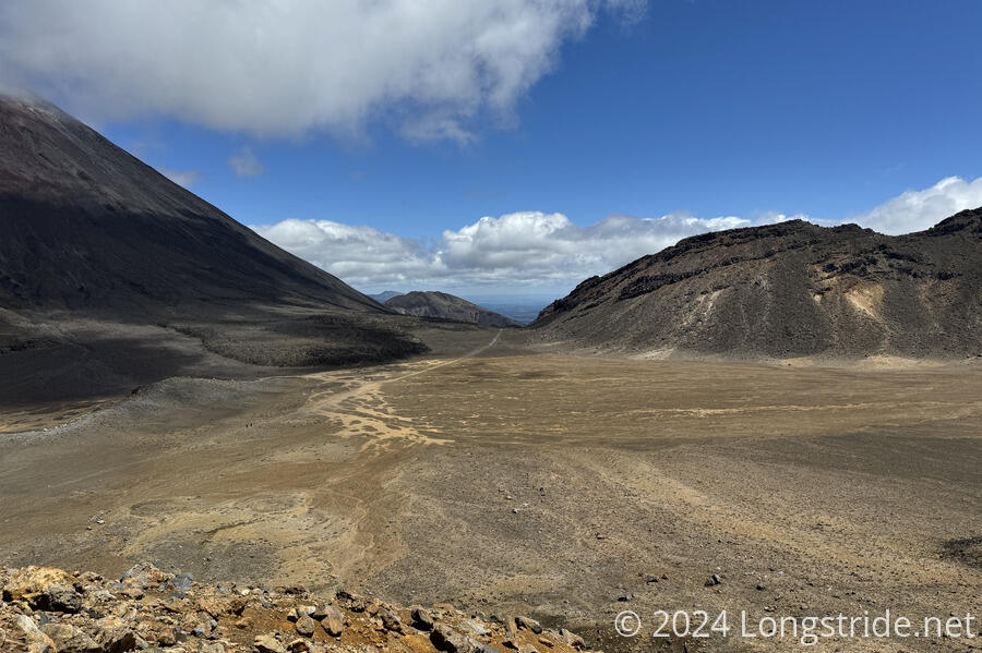
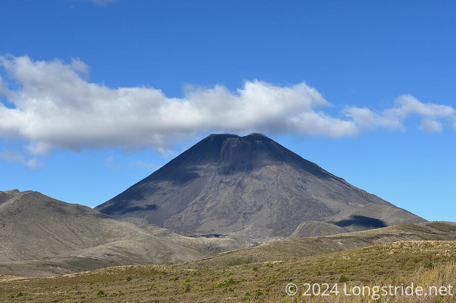
As we proceeded through the South Crater, the clouds began to lift from around Mount Ngāuruhoe.
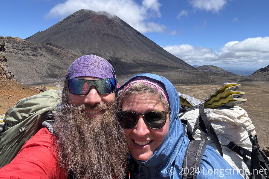
With an almost idealistic conical volcano shape, Mount Ngāuruhoe was used as the basis for Mount Doom in the Lord of the Rings movies. It last erupted in 1977.
Traversing the South Crater, we passed through a stretch with steam rising from the ground. We didn’t see any obvious vents, but the ground was warm to the touch. The volcano may be dormant now, but it’s certainly not extinct.
Leaving the South Crater, we began our descent from the volcanic plateau. A sign in a privy said that, on average, there are two rescues per week from the Tongariro Alpine Crossing. Given what we saw some people wearing today, that doesn’t surprise me. A little past the toilets, a sign with a life-size photo of a park ranger warned that “That was the easy part. It’s much harder ahead!” Given we were hiking the trail “backwards”, we joked about how much harder the trail had to be, and that since we were “feeling tired”, we’d have to turn back like the sign recommended.
After following a nice boardwalk through a rugged boggy area near a creek, we reached a fork in the trail, to the Mangatepopo parking lot, and the Mangatepopo Track. We stopped for a break. A sign just before the fork warned that hiking the Crossing today was not recommended due to hazardous weather.
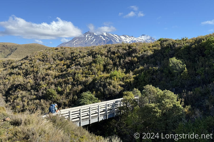
The last section, 9 km from the fork to near the Whakapapa Holiday Park, along the Mangatepopo Track was terrible. There clearly used to be a nice trail, but it eroded nearly entirely away due to lack of maintenance. The trail was often a narrow flat area above a drainage chasm (frequently a meter or more deep), or wet. Often, the remains of a staircase required acrobatics to get up or down. It would be very easy to slip and get seriously hurt, especially when muddy. (Fortunately, it wasn’t too muddy.)
Somehow, I was flying down this section; the thrill from the Tongariro Crossing, plus a pack with only a day’s worth of food, gave me a good boost through the last section, arduous as it was. There were also plenty of good views of both Ngāuruhoe and Ruapehu.
After over 34 km (and 12 hours) of hiking, we arrived at the Whakapapa Holiday Park in Whakapapa Village. CareFree and I had booked bunk space here for two nights; Peter, Susana, and Hannah hadn’t reserved space (and getting there after the office closed and seeing a No Vacancy sign wasn’t encouraging), so they tried to find a tentsite while we went to drop our stuff off at our bunk. We planned to meet up again in the dining room. (They couldn’t find space, and ultimately camped down the road on private property with the blessing of a security guard.)
We picked up our key from the late arrivals box, walked to our lodge, and went into our bunkroom. We found, to our dismay, only one available bed for the two of us. We were pretty exhausted and didn’t really want to have to deal with this, but we called the Holiday Park’s service number, and got in touch with the night manager, who, after some options we really didn’t like, offered to put us up tonight in the “Dojo”, a tiny cabin in the private area behind the campground host’s house.
Although the cabin was extremely minimal — a queen bed, an overhead light, and a single electrical outlet with a heater plugged in — we were happy to have a quiet, private room to ourselves.
The kitchen was a loud, bustling place, which we didn’t much care for after a long, tiring day. We very briefly considered hiking out tomorrow instead of staying, but there were no reasonably priced places in National Park Village.
The Tongariro Alpine Crossing was one of the best sections on the TA so far. It was well worth the two-day wait for the weather.
Tomorrow, we’re killing some time by hiking to some lakes in Tongariro National Park. This will allow us to get to Whakahoro on the 5th to start our canoe trip down the Whanganui River the next morning.