An unexpectedly long, tiring day crossing the Bryant Range brought me short of the Richmond Range.
After being uncomfortably hot yesterday, the cool morning was refreshing, even if it didn’t help me start hiking any earlier than usual. Not surprisingly, I was the last out of the hut.
Leaving Middy Creek Hut, a narrow, steep, rocky trail led to another rickety suspension bridge. Once across, though, the trail was relatively decent, with rocks and roots on a steep ascent up the side of the mountain to Rocks Hut. The trail was forested, but occasionally opened up a little, letting in a nice, cool, refreshing breeze.
Assuming it was going to be hot again today, I took the ascent slow and steady. There weren’t many views along the way, so there was little reason to stop except to catch my breath on occasion.
The 5 km, two-and-a-half hour climb brought me to Rocks Hut, perched near the ridge. I stopped for a break, chatting with Cam and Kennedy. (Dash had already left by the time I’d gotten there.)
Since I’d drank a fair amount of water on the way up and was already sweating profusely — my shirt was completely soaked — I drank extra water at the hut, and refilled my water bottle with water filtered from the hut’s tank.
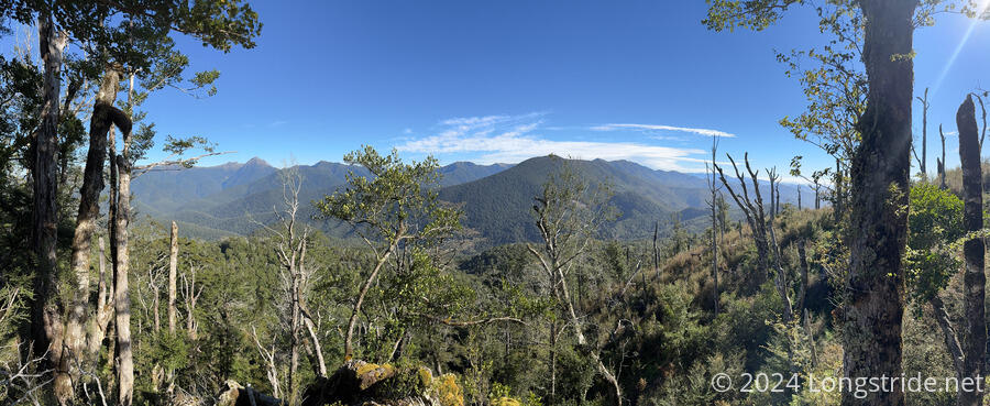
Leaving the hut, I continued on a much more moderate climb along the ridge, first going through a few muddy areas, and then gradually diminishing forest as I bounced along the ridge. After going through a short overgrown stretch through an area of deadfall, I stopped for a break where the forest mostly cleared to the south, just before the last steep climb of the day, giving a view towards the Richmond Range. It wasn’t the world’s greatest view — there were still a few trees in the way — but it was pretty much the only view of the day so far.
This 5 km stretch also took a little more than 2 hours, but at least some of that was due to me taking time to figure out how to (successfully) get through the muddy areas without getting my feet wet.
As I was packing up to go on, I happened to notice, just by chance, that my water filter’s dirty water bag wasn’t in the pouch with my filter. Since my filter’s nearly useless without it, I can, and unfortunately have improvised a working solution with my foldable water bottles and pieces from my water kit. But the last time that happened, on the Pacific Crest Trail, ordering a replacement water bag and having it shipped ahead to me was a feasible (if expensive) thing I could do. Here, in New Zealand, not so much. Not willing to leave it to chance that there were any hikers behind me who would bring it with them, I made the painful decision to hike back to Rocks Hut to retrieve the bag.
I did some mental math, and decided that this was going to cost me four hours (plus some snacks, but I had budgeted for an extra day in case of bad weather, so I wasn’t worried about that). It seemed unlikely I’d reach my goal of Hacket Hut today, but at least there was Browning Hut, a few km sooner. That I could — and would have to — reach before it got dark.
It took just under an hour and a half to return to Rocks Hut. (I was motivated to move quickly, it was mostly downhill, and I knew where I could and couldn’t step through the mud pits.) Surprisingly, the overgrown sections seemed far shorter than I’d remembered them being.
Back at Rocks Hut, my bag was hanging exactly where I’d left it, on the pack hooks just outside the front door. Also now at Rocks was Irit, from Israel, the hiker Dash and Cam had been waiting on yesterday.
After a short break, I returned back up the trail, taking just under two hours to return to where I’d taken my break. I’d intended on stopping there again for a quick snack, but I didn’t really notice when I got there, distracted by an old guy out for a (late) day hike, and the overgrown sections, which were just as long as I’d first remembered them being. (Going downhill, I must have had a better view of the ground that let me go quicker.)
At the top of the trail for the day, there was a nice little viewpoint. However, when I left it, I lost the trail, going off into some overgrown nonsense. Realizing that wasn’t the trail, I went back, and went off into different overgrown nonsense, which at least seemed like it was the trail (and it did seem to follow the line on my map).
After a little while, I realized I was completely off-trail. I made the decision to aim for where the trail was supposed to be, which took me through a stretch with downed trees. Not wanting to get even further off-trail, I made the dubious decision to climb over the fallen trees, which I regretted once I’d committed to one and found that the ground was further below the trunk than I’d realized. (It didn’t help that there were shoulder-high ferns, and I couldn’t see the ground at all. If I didn’t have my poles to use as probes, I would have been in an exceptionally bad place. I didn’t want to have to use it, but having the PLB I got in Wellington assuaged some of my nervousness through the tangle; if I got stuck, at least I’d be able to call for help.)
It took some effort, but I managed to work my way out of the tangle, and found my way to some “trails” heading down the mountain, vaguely in the direction of the TA. Worried the actual trail would be difficult to find in the forest, I let out a shout of joy when I caught a glimpse of one of the orange arrow trail markers on the side of a tree, guiding me the rest of the way back to the trail.
A minute later, I stopped for the break I’d promised myself I’d take once I’d gotten back to the trail. I was off-trail for about half an hour (and gained only about half a km down the trail in that time). That was enough time to allow Irit to catch up with me. When she did so, she gave me my towel she’d found on the trail somewhere between where I got back on, and where I stopped. Somehow, in all the climbing over and under trees, I didn’t lose anything, but once I got back to the trail, I managed to drop something almost immediately!
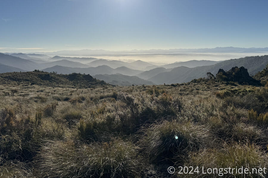
After my very quick break, I continued on. The trail exited forest, going through a large open expanse of tussock, with many narrow rocky paths crisscrossing each other and making the actual trail slightly hard to follow. It felt a little like the early desert on the Continental Divide Trail.
This open space gave a nice view to the north, towards Nelson and the Tasman Bay. Fog covered much of the lower elevations, giving the hills there a ghostly appearance, and making it hard to tell what exactly I was looking at.
A long, often steep downhill made for somewhat slow going. The trail provided one last challenge for the day: the trail crossed a creek, but erosion made it impossible to climb up to the trail on the other side. Fortunately, it was possible to rock-hop down the creek to a point where the trail came closer, and from there, it was easy to get back on the trail and smooth hiking down to Browning Hut. Exhausted, I reached the hut by 8:30, less than 15 minutes before sunset, with Irit right behind me.
Also in the hut was Uwe, originally from Germany and now living in New Zealand, who hiked the TA southbound during the pandemic lockdowns, and is this year hiking it northbound.
I got water and cooked dinner, grateful to have a hut to stay in; setting up a tent would have taken much of the precious little daylight left.
Later in the evening, when I was outside, I saw a possum on the trail next to the hut. It looked at me, standing up on its hind legs for a few seconds, before turning around and running back down the trail.
Tomorrow was already going to be a hard day, with a long and very steep climb into the Richmonds, but now it’s going to be a few kilometers longer as I have to finish dropping out of the Bryant Range first. But, unless I want to eat into my one-day supply cushion, I don’t have much of a choice but to make it to Slaty Hut anyway.