A day of hard but absolutely beautiful hiking took me through the Cirque of the Towers and back to the CDT through a landscape pock-marked with lakes.
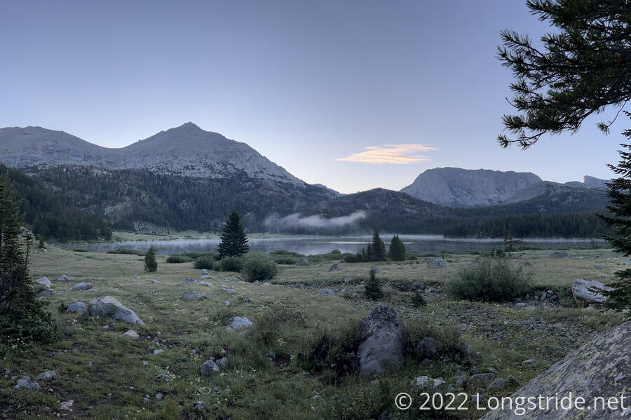
I woke up early, and was forced outside to get my food bag so I could eat breakfast. Once I had my food, though, I retreated back into my sleeping bag; it was cold and wet out, neither of which was conducive to getting an early start.
By the time I did get out of my tent and start getting ready to leave, the sun had risen, though not yet above the surrounding mountains. A small cloud of steam hung over the lake.
After retracing my steps back to the trail from our campsite, I began a somewhat steep climb through a small forest up towards Jackass Pass. The first couple of miles or so were not bad, though a lot of the trail was wet thanks to yesterday’s rain. After climbing a bit, the dirt ground gave way to rock, and the trail had some low-difficulty rock scrambles that were mostly just a minor nuisance.
For much of the climb up to Jackass pass, I was in shade — despite leaving camp after 7 am, the mountains still blocked the sun for a while longer.
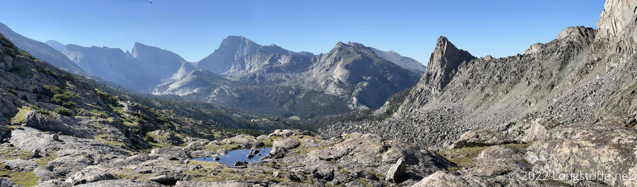
The steep climb up through the rocks brought me to a viewpoint south of Jackass Pass. Looking back to the south, I could see Temple Pass, which I hiked over yesterday.
From the viewpoint, there was a rapid 200 foot drop, and climb back up to Jackass Pass. As I neared the pass, I passed two hikers and a dog heading south, the first of many I’d see today.
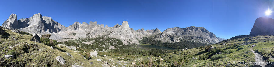
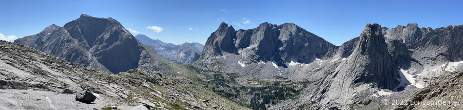
From Jackass Pass, I climbed a little bit up the side of the saddle, taking in the enormous panorama of a glacial cirque ringed by massive granite mountains. Words (or photographs) can not really do the area justice, except to say that this is, without a doubt, the most impressive view I’ve had on the CDT.
I stopped to admire the scene for several minutes, before heading down from the pass, towards Lonesome Lake, the lake near the head of the glacial valley. I passed a family hiking up to the pass, and shared with them a few photos I took of them hiking from a distance — they were overjoyed to have a picture of themselves.
The trail downhill became a little difficult to follow in a couple of places, with an old route not sufficiently closed off, and leading to a steep rocky slide that took some maneuvering to safely navigate.
Now down on the valley floor, the trail looped around the east side of Lonesome Lake, on a wet, brushy trail with no small number of little creeks feeding into the lake. It wasn’t easy to keep my feet dry.
After passing a few more weekend hikers, on the north side of the lake, after a short climb up from its shore, I stopped to take a break on a large rock just before entering forest, where the steep climb up to Texas Pass began. I was off to a slow start, only hiking four miles in three hours.
Breaking the quiet and tranquility of the scene were loud voices. It took a little while to see where they were coming from, but eventually, I spotted a woman and pair of teenage girls, emerging from the forest beyond the south side of Lonesome Lake, about half a miles away. I couldn’t understand what they were saying, but it was impressive they were loud enough to be heard from that distance. They may well have been the loudest hikers I’ve ever heard.
The loud hikers briefly passed me as I was packing up from my break; I passed them again on my way up a steep forested climb, one of, if not the steepest climb I’ve had this hike.
Climbing above the forest onto a rocky expanse, several possible routes emerged, and it wasn’t clear which was was the intended route. I picked one that headed in generally the right direction. It might not have been the most optimal route, but at least I was making forward progress.
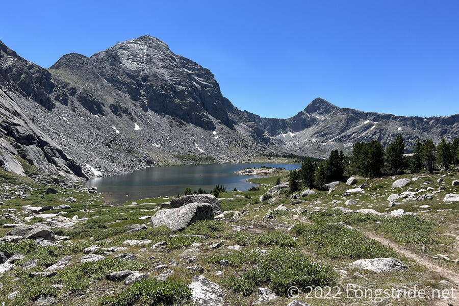
Being above the treeline gave me fantastic views of the cirque, and especially towards Pingora Peak, a large granite pillar jutting up from the valley. I just barely made out an orange line crossing part of the mountain. Looking closer, I could see three mountaineers ascending the peak’s steep side. As I slowly hiked towards Texas Pass, they gradually made progress up Pingora. I could also hear the loud trio behind me, even when they were too far down to be seen.
It took me a little over an hour to hike the mile to Texas Pass, gaining 1300 feet of elevation. While not technical in any way, it was one of the hardest hikes I’ve ever done, way harder than it should have been. Even with the jerry-rigged load lifters on my pack, the weight distribution was too far back, making me unbalanced and requiring more effort to climb up than it should. Still, it was beautiful at the pass. It would have been a great place to take a break — a few small groups of hikers taking breaks there clearly agreed.
As I crossed over Texas Pass, a large group of hikers finished their climb up from the north side of the pass. They had a much more difficult time: from Texas Lake at the bottom of the approach to the pass, it’s a 670 foot climb over three tenths of a mile: nearly 2300 feet per mile, which is absurdly steep. It didn’t help that portions of the trail were loose rock that easily rolled downhill just by walking near it.
Taking my time to not slide down the mountain, it took me half an hour to finish the hike down to Texas Lake, passing by several more groups of hikers (and a couple of dogs) along the way. With the lake relatively close to the side of the slope, and snow in the bowl not completely melted away, the trail went over a jumble of rocks, requiring a few little jumps over gaps to make it along the lake.
I passed a couple with three dogs taking a break at the lake; two of them were quite unfriendly, growling and snarling, and they had to hold them back. Their third dog was entirely chill, but followed me for a little while, refusing to listen to their calls for it to come back.
Later, I passed a guy with a very well-trained dog that went off-trail and sat down on command. I wish more people taking their dogs out on hikes ensured they were so well-behaved.
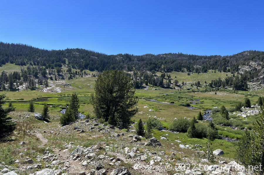
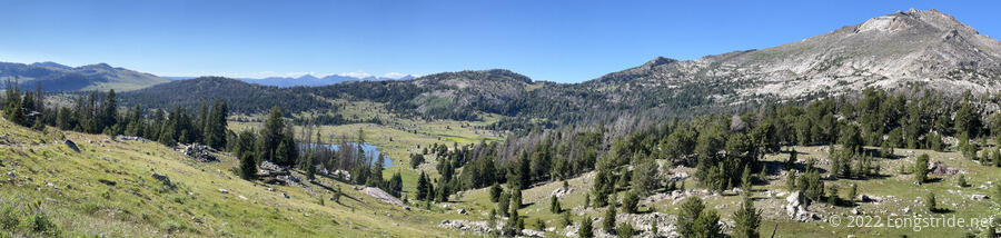
Once past Texas Lake, the trail began a gradual downhill that lasted for the next six miles. It didn’t take long for the granite surface to give way to dirt and grasses, and I stopped for a second break at a campsite near one of the many lakes I passed on the way down the glacial valley.
Between Billys Lake and Shadow Lake, the valley turned a corner and widened, giving broader views. The trail followed Washakie Creek, the outflow of Shadow Lake, crossing it once, and passing through several areas filled with willows. After diverging from the creek and partially climbing a hill, the Cirque alternate ended, and I rejoined the CDT, once again in the foothills on the outskirts of the Winds.
I lost track of the number of hikers I saw while I was leaving the valley. Once I got to the CDT, though, they all disappeared, and I was back to the typical isolation the CDT provides.
The gentle downhill ended at the East Fork River, wide and knee-deep. I took off my boots (and put on my crocs) while crossing so I wouldn’t have to hike the last part of the day with wet feet. On the other side, I climbed partway up a hill, and then stopped for a break at a campsite with access to a small creek.
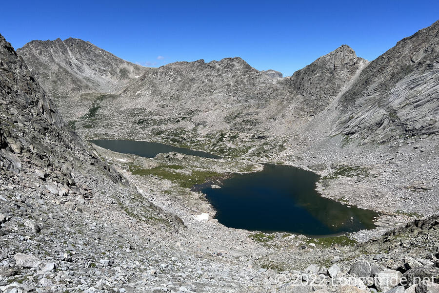
A bit more climbing brought me to a plateau riddled with rocks and small lakes, scenery quite unlike any other on the trail so far. I’d have been tempted to make one of the lakes a campsite if I hadn’t been so short on miles at that point.
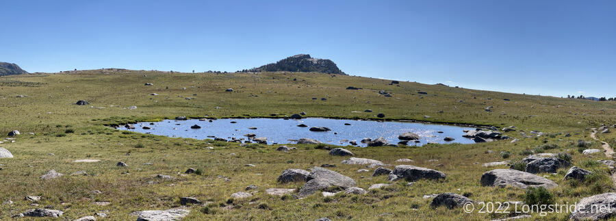
The trail through the plateau began a long, gradual descent, passing near dozens more small lakes, as the granite peaks of the Winds formed a clear boundary on the to the north and east.
As hard as the past couple of days have been, the huge variety in landscapes have made this section of the trail more than worth the hardship.
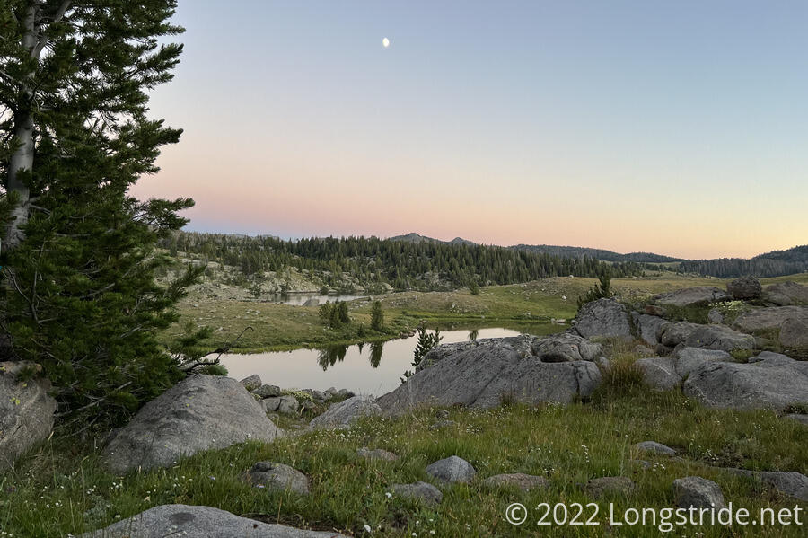
As the trail approached the large Raid Lake, it alternated between grassy meadow and pine forest. There were signs of recent maintenance, and a set of hard hats laid next to the trail. Now about an hour before sunset, I began looking for a campsite. I found one hidden away just uphill from the lake.
I set my tent up quickly — mosquitoes were buzzing around in large numbers. One of the trail maintainers whose work I’d seen earlier called over from near their campsite a little further up the hill, just to let me know that they were there.
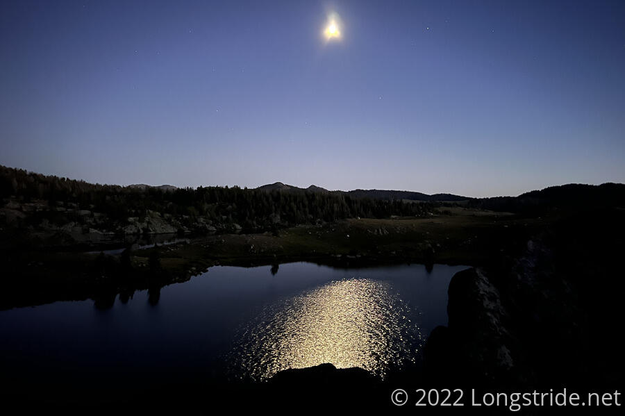
The mosquitoes did made dinner a bit annoying, but I had a great view overlooking the lake. After sunset, an incredibly bright moon made it easy to see outside. There were barely any stars visible, but the reflection on the lake was nice.
I only hiked just short of 18 miles today, which would have been a further blow to my plan to hike to DuBois, if I hadn’t already decided to go to Pinedale. The side-trail to Pinedale is in 23 miles, plus another ten to the trailhead, so I’ll most likely be in town the day after tomorrow.