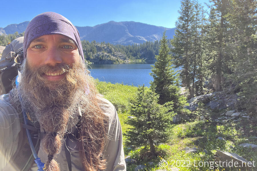
After passing over one of the most scenic passes of the CDT, I followed side trails for most of the day to arrive in Pinedale, my next trail town in Wyoming.
Having open views of the sky at camp is pretty nice. Although the moon was very bright last night, limiting visibility of the stars, I saw a fireball streak past because I just happened to be looking in the right place at the right time.
This morning, I wasn’t very quick leaving camp, despite knowing that the sooner I did, the sooner I’d be in town. Strangely, it felt colder in my tent than it did outside. But a nice piney smell filled the air shortly before the sun came over the mountains, and that finally got me moving.
From the saddle I stopped at, the trail followed a shelf above a bit of a bowl that lead down to a lake. A bit lower than the campsite I made last night, it took the sun longer to shine here, and it was a bit damp and musty. I was glad I didn’t stay here; my tent was dry where I was, and it wouldn’t have been here.
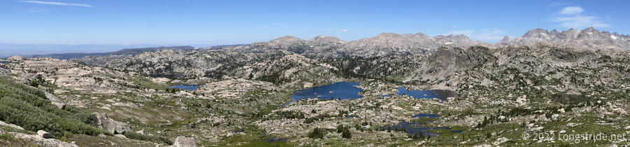
After crossing a small snow field, I passed over a small pass overlooking a valley filled with lakes. The Winds continued to impress with scenery.
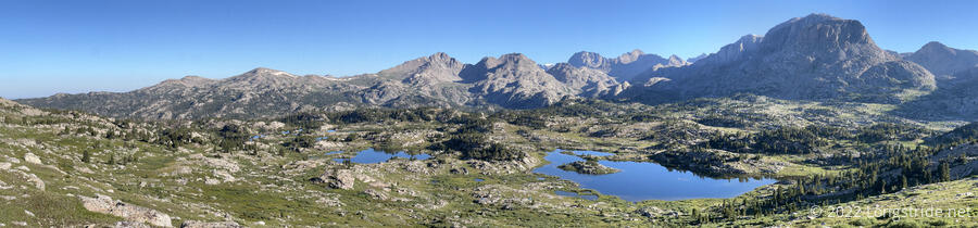
Descending from the pass, I could see quite a few tents; this was clearly a popular camping area for weekend backpackers.
Winding around a bit, I reached Pole Creek, one of the widest creeks I’ve had to ford on the trail. The recent rain seems to have flooded the creek a bit; it was clearly overflowing its channel onto the bank where the trail crossed. I took off my boots and crossed, passing my first opportunity to exit to Pinedale — on the south side of the creek, the Pole Creek Trail turned southwest, heading towards the Elkhart trailhead. Had I taken that trail, I’d have had to cross Pole Creek several times (further downstream, where it’d have higher flow), but that would have let me skip going over the next pass. Prefering more climbing (and more CDT) to wet feet, I kept going.
From Pole Creek, the trail began a climb up to Lester Pass, going past a couple of lakes along the way. I stopped for a short snack break about two thirds of the way up.
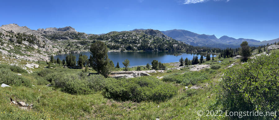
Passing more lakes and creeks, and a few waterfalls in the distance, I slowly climbed up the valley, and then the valley’s steep rocky headwall, towards Lester Pass. Looking back was a georgeous view of lush green alpine meadow, dotted with lakes that reflected the blue sky.
The pass itself was a saddle between Mount Lester and a smaller hump, and covered with boulders. Five large backpacks sat propped up against a rock, with no one nearby. Off in the distance, on the smaller hump, though, I saw several people sitting, so I figured the packs must belong to them.
The view north of Lester Pass was similar to the view south. Gray granite peaks shaped like sharp teeth rose up to the north, behind a boulder-strewn meadow of blue lakes.
Dropping down from the pass, the trail descended steeply, with rock stairs in places. My right leg became a little wobbly from the continued steep downhill.
Shortly after noon, I reached the trail junction with the Seneca Lake Trail. Turning off onto this trail, I began heading towards the Elkhart trailhead and Pinedale.
The trail began by wrapping around Little Seneca Lake, turning southwest. This trail was quite wet, with flowing water and puddles on the trail. It occasionally made for some slow going as I avoided getting my feet wet. I didn’t want to imagine how much wetter the trail would have been two or three days ago after the rain. I hope it’s not going to rain before I get back on trail, since I’ll have to hike through this area again to get back to the CDT.
The trail also passed Seneca Lake, with the trail seemingly cut into the rock face alongside the trail; the lake went right up to the side of a steep slope. There wasn’t much of a shore, though there were quite a few rock outcrops and little areas off the trail that overlooked the lake. Many of them were occupied by day hikers.
After turning away from Seneca Lake, the trail followed a valley downhill. Parts of this trail were a mud pit, but it was also evident that there’d been a lot of trail work here recently to help with the problem.
After several miles, I reached the junction with the lower half of the Pole Creek Trail, and followed that the rest of the way to the trailhead.
Both the Seneca Lake and Pole Creek Trails had their own beauty, but I was mostly focused on moving as quickly as I could, so I could get to town before too late in the evening. I passed quite a few other day- or weekend hikers, mostly heading towards the trailhead, as well as a couple on horseback, and a group of eight people with pack llamas.
While the Seneca Lake Trail had its running water problems, the Pole Creek Trail was victim to an incredible number of blowdowns. Apparently, there was wind storm two years ago that flattened the whole area. For miles, the trail was lined with cut trees piled up; I can’t begin to estimate the amount of work trail crews put in to clear the area. There’s still more work to be done, but the crews that made this trail passable deserve a lot of credit.
I spent most of the day today on side-trails: only about 7.5 miles on the CDT compared to about ten to get to the trailhead. It felt like a lot of effort for not a lot of progress.
Arriving at the trailhead around 5 pm, I found a parking lot filled with cars, but no people. I also found that the tip on one of my trekking poles fell out, and the other one is on the verge; I’ll need to try and find new pole tips in town tomorrow.
I walked to the information center, just down the road from the trailhead, and chatted for a few minutes with the ranger and another woman who was there. Then, I went across the street and started trying to hitch into town.
After about half an hour, I got a ride from Chad and Kim, who’d passed by earlier, and decided to come back and see if I was still here. Half an hour later, they dropped me off in town, at a Chinese restaurant.
Food was okay, about what you’d expect from a Chinese restaurant. I arranged to stay at the Jackalope, a motel that converted two of its rooms into hostel-style hiker bunks, and walked there after I finished eating.
There were already several hikers there, all southbounders. One of them gave me some useful information on how to get up to Glacier, should I decide to flip up to Glacier and head south.
Later, in the evening, Stumblebee, Bass, Cool Whip, Recon, and Wild Man arrived, and we went to a bar for drinks and pool.
“Halfway” on the CDT is a funny concept, given all of the alternates. In terms of the official trail, the halfway point was somewhere on the last day in Colorado, or somewhere in the section of trail the Cirque of the Towers alternate skipped if factoring in the 250 miles of New Mexico I still need to complete. In terms of actual mileage I’ve done and plan to do, halfway is probably somewhere in the Basin (assuming I take the Big Sky Alternate, depending on how much it cuts off). “Worst-case” would be if I hike the remainder of the official trail from here to Canada (and in New Mexico), which puts halfway somewhere today.
No matter how I look at it, halfway is now definitely behind me. Halfway ought to be exciting. But for me, right now, it’s not. There’s still far too many miles to go…