I think I've said it before, but, Bed & Breakfasts usually make terrific breakfasts. Today's at Nye's Green Valley Farm was blueberry pancakes, eggs, and sausage. The blueberries were fresh-picked from their farm that morning, and everything was delicious.
I got back to the trailhead around 9, and got started, heading towards the Lamoille River crossing. A light sprinkling of rain started just as I got out of the car, and lasted for just a few minutes, but long enough for me to put my pack cover on, which would come in handy later.
The day quickly got off to a lousy start, at the crossing for the Lamoille River, thanks to some terrible blazing: after a blaze on a tree with a map showing the high-water bypass route, the northbound blazes abruptly end on a tree at the river's bank, apparently dead-ending in a T intersection with another trail that follows the riverbank. I followed that trail in one direction long enough to be confident that it wasn't the Long Trail. Returning to the trail, I again consulted the map, and explored the river trail in the other direction, and now I was able to see the footbridge crossing the river — located across the channel whose bank I was standing on — and the map finally made sense: what I thought was the river was actually part of its floodplain, and what I needed to do was cross the floodplain (which isn't marked by any apparent blazes) and hike up the short distance to the bridge crossing the actual river (which I couldn't really see from where I had been standing).
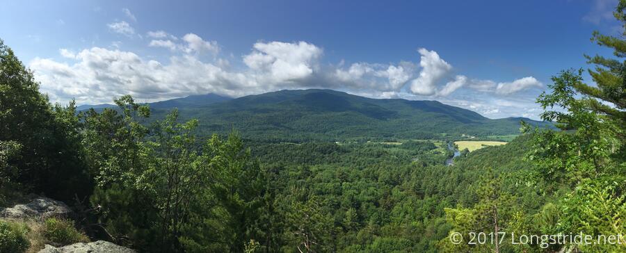
That runaround probably killed 20 minutes of my day; not an especially great start given the late starting time and threat of rain this afternoon. But, I continued on; it's not like standing around complaining about it would improve matters. Now, the trail led up the mountain to Prospect Rock (a second one, if you're keeping count; the first was two and a half weeks ago, on the way in to Manchester Center).
A short while later, I made another wrong turn. On a steep uphill, I didn't keep my head high enough to actually see all of the blazes, and turned right when I should have turned left. Blazes aside, it was an easy mistake to make: to the right looked like a perfectly good trail. Once I got to what appeared to be a rock scramble and hadn't seen any blazes, I decided I'd probably gone the wrong way. I dropped my pack and retraced my steps, finding where I'd turned wrong, and noticing the blazes. After going back to get my pack, I wished whoever put up blazes had used a double blaze to mark the change in direction, and continued on the way I was supposed to go.
While it was a steep trail to Prospect Rock, it was still a fairly easy trail (wrong turns aside), and I took a short break once I got there, just to take in the view.
A short while after Prospect Rock, I ran into Sidewinder. He mentioned that Climber was up ahead, meeting with a friend who came to hike part of the trail with them, and that they had been delayed an hour yesterday by the poor blazes, so they didn't get to where they wanted to be. (They did wind up camping out at Prospect Rock, which gave them a great sunset and sunrise.) After standing in the trail chatting for a bit, we continued on, to Roundtop Shelter, where we took a break and continued to talk for awhile, ignoring the rain forecast for the afternoon. (The shelter had an unusual L-shaped design, and skylights, a rarity.)
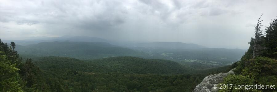
After two road crossings and a small mountain in between, the trail climbed up Laraway Mountain, which was evidentially very popular with day-hikers. As with earlier in the day, the trail was steep, mostly though dirt, and easy to hike. Rain started not long before I reached the mountain's scenic view, and along the way, I passed Climber and her friend, Scout. Although I had been planning on taking my second break at the view, the rain changed that into a quick photo stop.
The rain let up around 4, near Corliss Camp, my destination for the day. Another odd shelter design, there were four bunks, plus an "attic" with space for another six or eight hikers, depending on how cozy everyone got. Also at the shelter was another Farm and Wilderness camp (different from the one I had run into a few days ago).
There were already five hikers in Corliss Camp by the time I got there (plus the F&W group), and hikers continued to trickle in until late: Climber, Scout, and Sidewinder were first, followed by Moe and Mugs, two childhood friends hiking the Long Trail together; followed later by Anne (who is out for the second time to complete her Long Trail section-hike), and Sometime Never.
The rain picked up again in the evening, and I resigned myself to having cold, wet clothes in the morning.
Tomorrow: 15 miles to Tillotson Camp, through a place called "Devil's Gulch".