In the valley, it was much warmer overnight than it was on the mountain the previous night, so getting out of my sleeping bag at 4 am wasn’t terribly hard, even if I was still tired. We missed our intended 5 am start time by about 20 minutes, but still got going before sunrise.
My shoes were still damp from yesterday, but once I got dry socks on, it wasn’t too bad, and as long as I could avoid actually stepping in water today, they would probably dry out as I hiked. Of course, almost immediately after the four of us left camp, we came across a wide, gushing river of water flowing down the mountain and crossing the trail. It took some creativity to cross without getting our feet wet, and we had to take our time doing so, but we were largely successful. (It was a bit hard to tell, given it was still pre-dawn, but I’m pretty sure most of the water wasn’t flowing in a stream channel; it was just gushing down a substantial portion of the hillside and across the trail.)
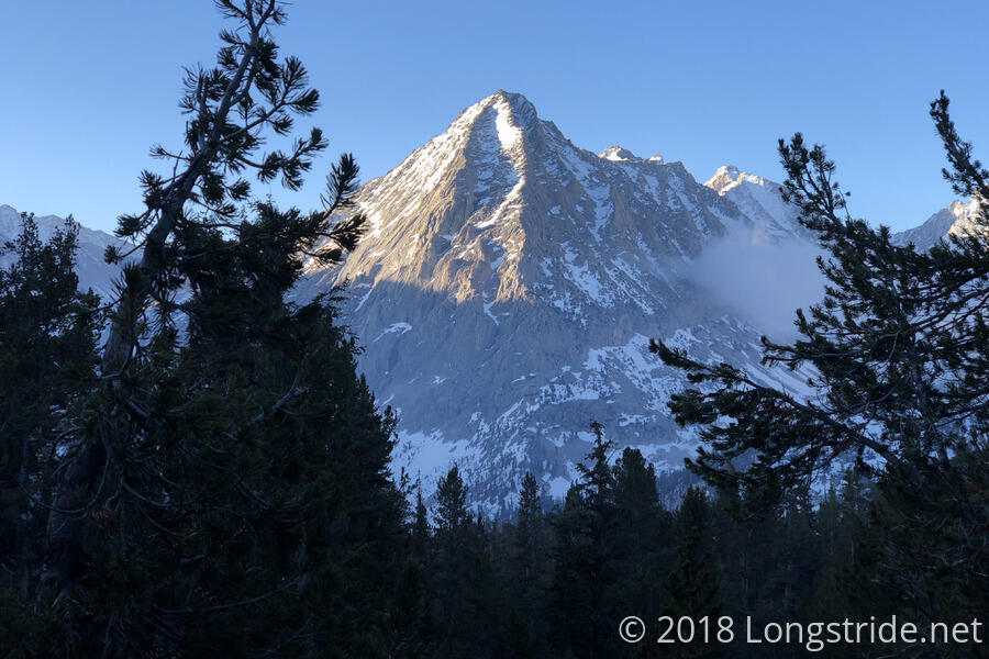
Once past the stream, the PCT started a (relatively) short, but steep climb up towards the Kearsarge Trail that would take us to Kearsarge Pass. The climb gave us more excellent views of West Vidette Mountain, as the trail repeatedly entered and left the forest on the mountain.
All of us were tired, but Dylan most of all, and his pace would gradually slow to a near-crawl throughout the morning. Fortunately, the PCT was largely clear of snow until we got to the Kearsarge junction, after which point there was more snow as the Kearsarge Trail climbed up to the pass. We did have one boon, though: because we had started so early, even with our slow pace, what snow was there was pretty firm and we didn’t sink into it much.
Still, though, we we hiked just under two miles on the PCT, and now had a 7.5 mile side trail to get to a town a long distance away from the trail. This’ll probably be the furthest I’ve ever hiked off-trail to get to town.
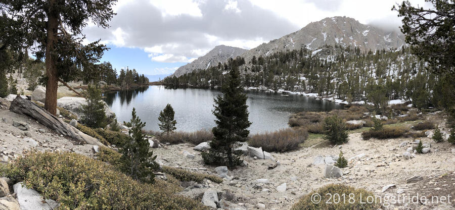
The Kearsarge Trail, less steep than the PCT from our campsite, gave us a series of beautiful views nearly the entire climb, enhanced by the several alpine lakes in the valley. The first was Bullfrog Lake.
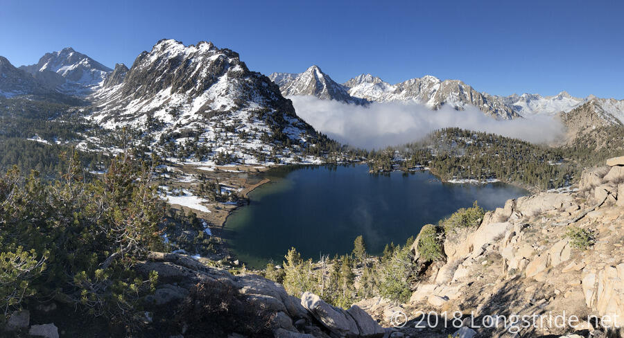
And as we continued to climb to the pass, other alpine lakes, partially frozen, became visible as well.
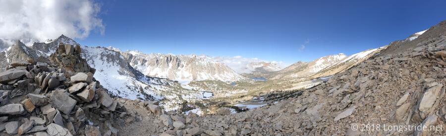
We reached Kearsarge Pass a bit after 9 am, and, with its east/west-facing view, got our first view of the desert in nearly a week. We rested at the summit for nearly half an hour, eating the last of our snacks and taking in the view. As we sat, the cloud in the valley we left slowly made its way towards us, though we hiked away long before it could have reached us.
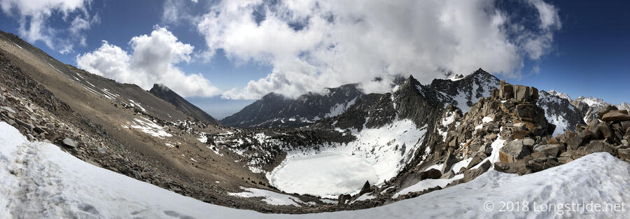
We had a very easy hike down the Kearsarge Trail from the pass. It was not as steep as the climb, and though there was some snow we had to avoid, we were pushed forward by our desire to be in town. There were no shortage of views on the hike down the mountain, either, and numerous waterfalls and lakes dotted the landscape.
Our goal was to get to the town of Bishop to stay at The Hostel California. To get there, though, would potentially require two long hitches. We somewhat lucked out on that account. As we were hiking down to the parking area at the Kearsarge Trail trailhead, we caught up with a day hiker, Danny, who was leaving the mountain after a short camping trip. Noting that he was carrying a small pack, a grocery bag of stuff, and a huge six-person tent all for himself, Quoi struck up a conversation with him, and he was willing to give us a ride from the parking lot to the gas station in Independence.
It was a tight squeeze, fitting the four of us (and him) into his two-door car, but we managed, and we quickly and safely got off the mountain (via road switchbacks just as windy as the trail switchbacks we hiked down) and to the gas station in Independence.
Hungry, we grabbed some snacks from the gas station’s store, and then walked out to the street corner to try and get a ride from someone going past. We hoped we wouldn’t have too much of a problem getting a ride, since Bishop was the next place anyone going north on the road would hit.
We had some difficulty getting a hitch. There were four of us, which by itself limited the number of people willing to pick us up, especially with three of us being guys. Quoi, being a woman, would normally have made it easier for us to get a hitch, but she a hard time standing up with us because she had cramps from lack of food. After about 15 minutes, we did manage to get a ride, and from a surprising source, as well. Mateo, the owner of Hostel California, and his two dogs, were returning to Bishop from Costa Rica, and he picked us up. He and Quoi recognized each other from last year, as well. It’s a 40-mile drive from Independence to Bishop, so we were very grateful that one person was willing to accommodate all four of us, and it was a lucky coincidence that it happened to be the owner of the place we were trying to get to.
The entire ride to Bishop, we drove up US-395, which runs up the middle of the mountain valley between the Sierra and the range to the east, which borders Death Valley. We were flanked on both sides by mountains; it was great scenery.
Entering Bishop, a sign warned of a large deer migration ahead; given that we’re now in the desert, this seemed pretty incredible, but apparently, it really is an actual “problem” here.
Once we got into the hostel, I quickly found Sassy K and her group hanging out in the outdoor common area. It turns out they had reached Forester Pass, but turned back once they saw there was unmarked fresh snow on the north side: they didn’t want to trailblaze and posthole through fresh snow. This meant they retreated 30 miles (!) back to Cottonwood Pass to go to Lone Pine, and then got up to Bishop.
Dylan, Flowers, Quoi, and I grabbed dinner at a nearby Mexican restaurant, El Ranchito. The food was quite excellent. Still hungry, we wandered over to a gas station to pick up some more snacks, and then went to McDonalds for more food. (I ordered a 6 piece McNuggets; I was incredibly tired and that was all I had the mental capacity to eat; they accidentally gave me 4 pieces instead, and when correcting it, upgraded me to 10 pieces.)
The hostel’s beds were all full, so the only place available for us to sleep in was a garage converted into a common area with tables and couches; there were so many people here that I only wound up with two couch segments to lay out on, rather than three, so I couldn’t actually fully stretch out. A large group of people continued to have a (loud) conversation in the adjacent outdoor common area, so none of this looks good for actually getting restful sleep tonight.
Tomorrow: the first day of a double-zero. Also... Mule Days?