A beautiful day of hiking awaited us as we started on the last leg of the trail, departing Rainy Pass and making our way more than halfway towards Harts Pass.
I got out of bed around 6:30. I’d wanted to get up earlier, and might have done so despite the cold (since I was inside), but with a house full of sleeping hikers, getting up before sunrise would just mean tiptoeing around everyone and trying not to make noise.
With only three and a half days of hiking to go, and six days of food in my pack, I wanted to get rid of some of the excess to lighten my pack. Between CareFree and another hiker, Lucky Duck, I managed to give away two days worth of food, leaving me with enough to make it to Canada, with a day to spare. In the process, Lamb Fat gave me a package of homemade dehydrated plums. A little heavy, I was uncertain that I actually wanted them, but I’d given away more food than what he gave me, and there’s rarely enough fruit on the trail, so I didn’t protest.
After taking awhile to repack, Good Karma, CareFree, and I left Ravensong’s Roost and walked back to Highway 20, standing at the intersection of the road to the general store, giving us easy access to drivers coming down Highway 20, as well as those leaving the store or the inn. Good Karma left us, going to the store for a small last-minute resupply, and within five minutes, we got picked up by a trio of day hikers, Lisa, Sue, and Sue, who took us back to Rainy Pass, where we left off yesterday.
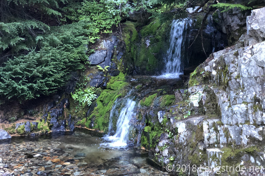
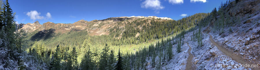
From Rainy Pass, we could easily see fresh snow on the nearby mountains from an overnight snowfall, and we got started on our morning climb. After a short walk from the pass down the road to the trailhead parking area, we entered forest, and began a several mile climb, first roughly paralleling the highway, then turning northeast, heading up a valley. Along the way, we crossed a few creeks and passed a few waterfalls.
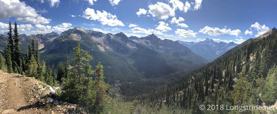
As we climbed higher, the forest gradually started to thin, and we got great views looking back down the valley. As we approached the treeline, climbing up the back of the valley via set of switchbacks, snow from last night graced the trail.
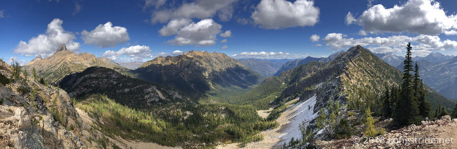
Our first break of the day was at Cutthroat Pass, which had amazing views into another valley, with a view down to Cutthroat Lake. Quite a few other people were taking breaks at the pass, including a group of mountain bikers who had biked up to the pass via another trail that reaches into the valley, accessible from another trailhead off of the highway. While we were there, Good Karma caught up to us, apparently also not having to wait very long to get a ride back to the trail.
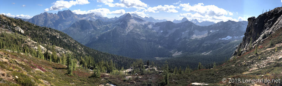
The trail ahead of Cutthroat Pass was largely exposed, easily visible from a distance, and we continued to head north, following the trail as it weaved around the mountainside, passing Granite Pass and heading to Methow Pass. It was beautiful out, with clear, blue sky overhead, and fluffy clouds in the distance. Today is easily the best weather we’ve had since leaving Skykomish. Today was also easily one of the most scenic days in quite a while.
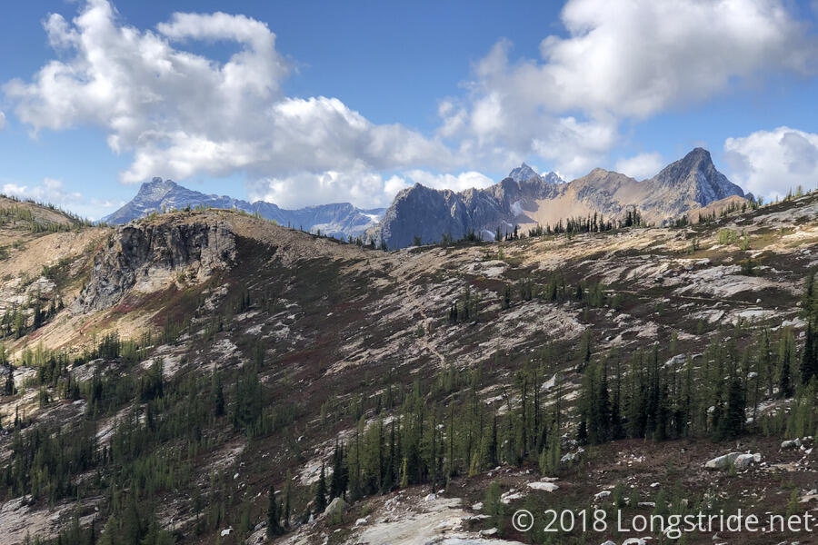
Remnants of yesterday’s snow continued to be visible, still visible near the top of the ridges on the north and east sides of the mountains.
We also passed the 2600 mile marker — all four of them — spread out about a fifth of a mile. This gives us about fifty miles to go to the terminus (and about sixty to Manning Park).
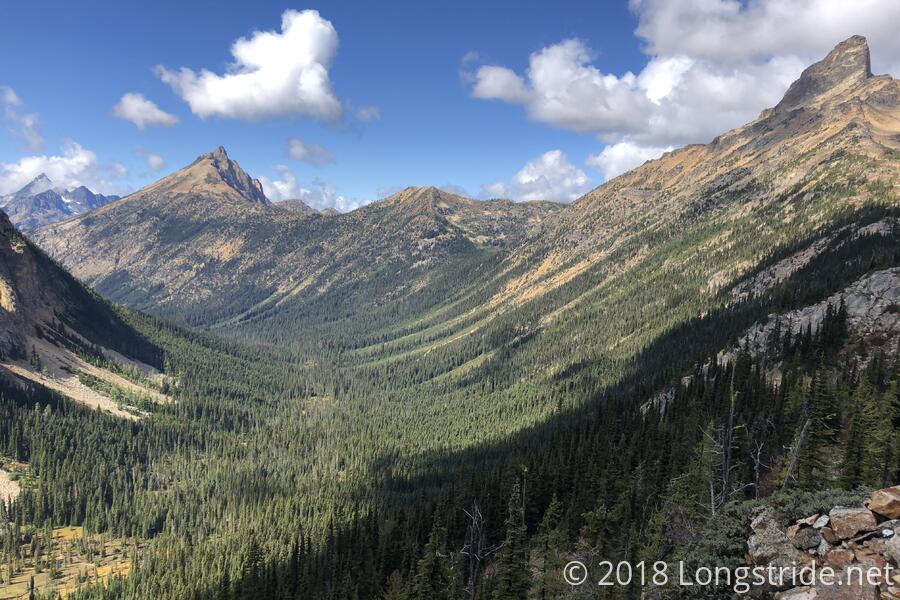
Our second break was at a flat meadow at Methow Pass, located on the side of the valley we had been traveling along, and at the head of another. We took a longish break there, taking in the views, as were three other hikers, one of whom had a lightweight camp chair. Justin and Fireman passed us, as did Phoenix.
Proceeding north from the pass, we descended into forest almost immediately as we dropped down into the valley. Jelly caught up with us after a short while, and we followed as he sped down the trail. The three of us caught up with Justin and Fireman, and CareFree and I went on ahead as Jelly slowed to hike with his partners. We also passed Phoenix further down the valley. In the forest, we were in a green tunnel, with fairly infrequent, though still amazing, views.
After just over 18 miles, we stopped at a campsite just before Brush Creek, settling on a tentsite partially hidden from the trail by trees overgrowing a narrow entrance. There were a number of other possible tentsites in the area, but this was the one that seemed least bad; even so, it wasn’t quite flat.
I went over to the creek to get water for dinner. On my way back, I stopped to talk to Phoenix, who had caught up and was taking a break at one of the campsites closer to the creek. I let her know where CareFree and I planned to camp over the next two days, and she gave me a deadline for when I need to be at Manning Park for a ride back to Seattle: 4 pm. This was fine, great even — I wanted to get there earlier in the day than that anyways.
Just before CareFree and I started to set up my tent, Jelly, Justin, and Fireman (and of course, Justin’s dog Jesse) arrived, and we chatted for a bit as they took a snack break. They indicated they're trying to finish on the 19th, since Justin has to get back to work a couple of days later. Jelly, however, needs to return to Harts Pass since he didn’t get an entry permit to Canada. I mentioned a discussion that I’d had at Ravensong’s yesterday. Someone had suggested taking the fire detour north from Harts Pass, since even though it was longer, it had less elevation gain, but then, to return by taking the PCT south through the fire closure. Supposedly, the story went, the fire was out (or nearly so), and the impact of the fire on the trail was very small, but the forest service didn’t want to “confuse people” by changing the closure for a second time this season. I myself was a bit dubious about this plan since hiking through a fresh burn area can be quite dangerous, but, it didn’t much matter to me, since I wasn’t going to be returning to Harts Pass anyway.
After the three of them continued on to the next campsite at Glacier Pass a few miles ahead, CareFree and I set up my tent and cooked dinner from inside my tent. With the sun heading behind the mountains, and a flowing creek nearby, it was getting somewhat cold out.
With only three more days to go on the trail, I’m quite looking forward to being finished, and yet, I’m not ready to leave the incredible scenery I’m now surrounded by.