Our penultimate day on the Tahoe Rim Traill, today we completed the overlap section with the Pacific Crest Trail and began our descent from the rim towards lake level.
CareFree and I had a simple plan for the day: hike about fifteen miles, stopping before the last uphill to get water, and then camp a few miles later at a site with views. We did exactly none of that.
We started hiking around 7:15, to noticeably cooler temperatures than it had been due to yesterday’s rain. It was also actually somewhat humid, even, which is not normally a word I would use to describe the Pacific Crest Trail anywhere in California. Still, though, the lower temperature was much welcomed, and we proceeded at (for this hike) a rather amazing pace down a very easy trail.
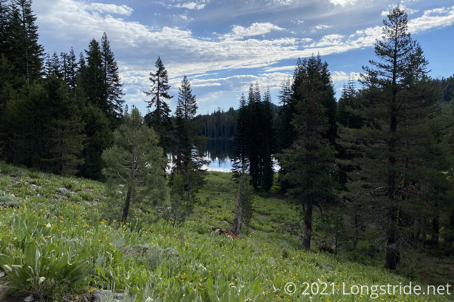
After less than an hour of hiking, we reached the northern boundary of the Desolation Wilderness, saying goodbye to that beautiful section of trail. A half-hour later brought us past Richardson Lake, where there were still quite a few hikers tearing down camp.
The cool, well-forested morning kept a lot of the sun off us, and the trail was surprisingly easy for a change. In two and a quarter hours, we hiked almost 7 miles, almost certainly a pace record for us on the Tahoe Rim Trail. We stopped for a break at a well-shaded campsite, and contemplated what to do about the rest of the day: we’d already hiked nearly half our miles and it wasn’t even 10 am yet! I pointed out that at our current pace, we’d be finished hiking by 2 pm.
We decided to hike to our planned water source and then reconsider there. And also, maybe not hike so fast.
Shortly after we left our break, we again ran into the couple from yesterday (who saw the rattlesnake). We finally got their names — James and Paula — and had another long conversation with them, made only slightly awkward because they were perched up on a rock about ten feet above the trail. I noted that they had the same gravity water filter that I do, and that wound us up in a conversation of other hiking trails. James wants to hike the Hayduke trail, which is somewhere on my list of trails to hike; while Paula generally prefers to read about them.
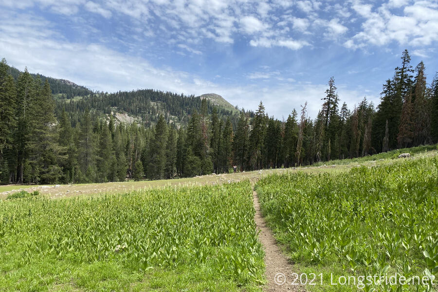
The trail continued through “generic Sierra forest” — I had little recollection of this part of trail — and started a climb, taking us through a meadow on the way to Barker Pass.
Most likely because it was the Fourth of July, the Barker Pass trailhead was full of cars and hikers, quite a difference from when I was here before when there was just one hiker.
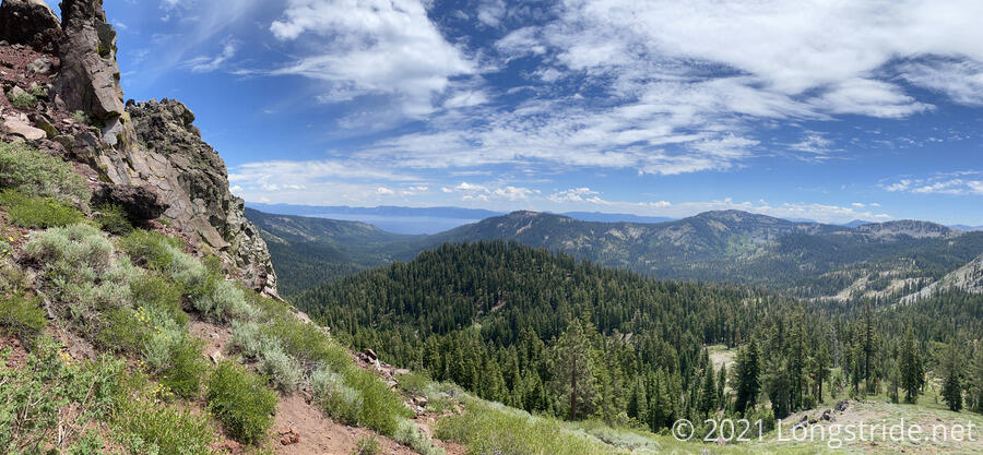
From Barker Pass, we continued one of our last uphill climbs of the Tahoe Rim Trail, and took a side trail to a view we both skipped while hiking the PCT (it wasn’t obvious it was just a short trail to a view, and not a longer trail to somewhere else), and got a great view of Lake Tahoe and a valley.
A bit further on, we stopped at a campsite with a wooden bench — so very comfortable to sit on! — and a creek, our planned water source for the rest of the day, and again contemplated our day. Only 1 pm, we were feeling good, the trail had been very kind to our feet today, we’d already gone twelve miles of our planned fifteen miles, and we felt like we had a lot more energy in us than to just stop after another hour of hiking.
So we opted to go past our initial plan and hike further down the mountain to a campsite just off a creek, giving us an even shorter day tomorrow.
James and Paula showed up after we’d started our break, and we continued our conversation from earlier. We also learned James’ trail name: “Shade”, because he liked to stand in it (and also tell other people they weren’t in it), a good policy to have on a trail with as much sun exposure as the PCT (and TRT).
We continued on, climbing up the mountain, to enter the Granite Chief Wilderness, another very scenic area. With the trail atop the ridge, it was quite breezy, which was welcome in the increasing afternoon heat.
Alas, we did not spend very long in the Granite Chief Wilderness; not ten minutes after entering, we reached the northern junction between the PCT and Tahoe Rim Trail, and we turned right, ending a “short” jaunt along a trail that had once been my home for six months, and turning to head towards Tahoe City to complete our loop around Lake Tahoe. Another ten minutes on the TRT exited us from the Granite Chief Wilderness.
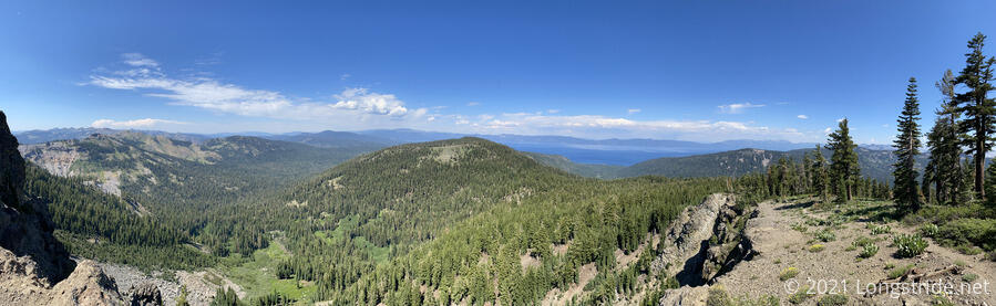
After a short climb up from the junction, we reached another trail junction, up to the summit of Twin Peaks. The comments on the trail guide suggested that there was a steep hike and bit of a rock scramble, so CareFree opted to remain at the trail junction while I went up. The first part was steep, though it was much easier to hike up than the very sketchy climb up Freel Peek a few days ago. Hiking up to the end of the trail, I got some great views of Tahoe and the surrounding area, but there were birds — Ospreys, I think — flying around and screeching, and while they never came close to me, they were a bit unnerving.
I started up the rock scramble, and maybe made it 40 feet up, before I decided that I wasn’t really comfortable going up further. It was rather steep going up (though not really that big a problem, since rock scrambling is a completely different set of movements than hiking), but I was more worried about the climb back down — up is always much easier than down. Even though I was probably only 100 feet away from the summit, I just didn’t want to take the risk of getting hurt on a side quest. After all, I’m a hiker, not a rock climber.
I returned to the trail junction, and we continued downhill from there.
The failed summit attempt sapped my energy a bit — I think more from the adrenaline spike of being fairly close to a cliff’s edge with angry birds screaming around me than the actual energy expenditure from climbing most of the way up — and I was a bit sluggish on the hike down the mountain to our newly planned campsite.
As a result of that, and stopping to admire two views (which we could have camped at if we’d brought water), we let James and Paula get ahead of us, and they took the campsite we’d been aiming for. (Sadly, there was only space for one tent there, or we would have gladly camped with them.) That forced us even further down the mountain, to the campsite we didn’t want: Ward Creek, where we’d been warned about a problem bear just before we got on the trail.
We got to Ward Creek around 5, one of our latest finishes this hike, and were disappointed to find a large group of hikers already there. We went ahead and checked a possible campsite a little further ahead, only to find that also taken. So, we returned to the Ward Creek campsite, cleared and slightly flattened a site on the outskirts of the group, and set up our tent.
This was our longest day this hike — 18.5 miles — and we were both tired after going further than planned. But this sets us up for an easy, relaxed day into Tahoe City tomorrow to finish our loop around Lake Tahoe.