We continued our third day on familiar ground as the Tahoe Rim Trail continued to follow the Pacific Crest Trail through the Desolation Wilderness.
Once again, it was warm overnight, which made it easy to get out of our sleeping bags. Unfortunately, that also made us targets for every mosquito around our campsite. We tried to move a bit quicker than usual so we’d get bitten less. I’m not sure it worked, but CareFree and I did start hiking shortly after 7 am, beginning our ascent to Dicks Pass.
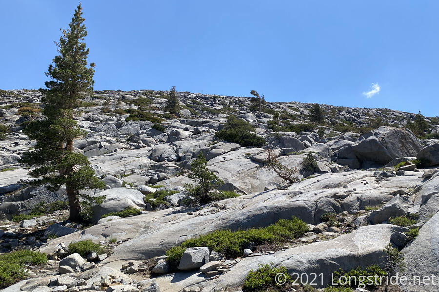
While we did have the advantage of low sun, there were still lots of rocks to contend with as we switchbacked our way up the mountain towards the pass.
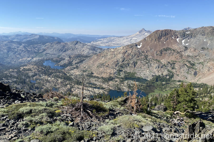
As we gained altitude, our perspective changed from a close-up of Susie Lake to a more overview perspective. Yesterday, at Susie Lake, CareFree and I had a brief discussion on whether or not we considered the area around our campsite as being “desolate”. It seemed hard to call it as such when there was so much life: trees, flowers, chipmunks, birds, marmots, and even mosquitoes. But, as we ascended higher, the true nature of the “desolation” became apparent. While there certainly were trees and lakes (and animals in and around them), there was a whole lot more barren rock. From a high level, the name “Desolation Wilderness” does seem appropriate, even if it doesn’t when you zoom in closely.
Also as we gained altitude, we were able to see over the nearby ridges, giving us another view of Lake Aloha.
Just before we got up to the pass, we caught a great view of Dicks Lake, which I’d forgotten about.
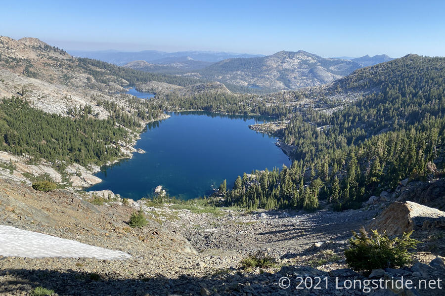
And the view from Dicks Pass was every bit as amazing as I remembered it being.
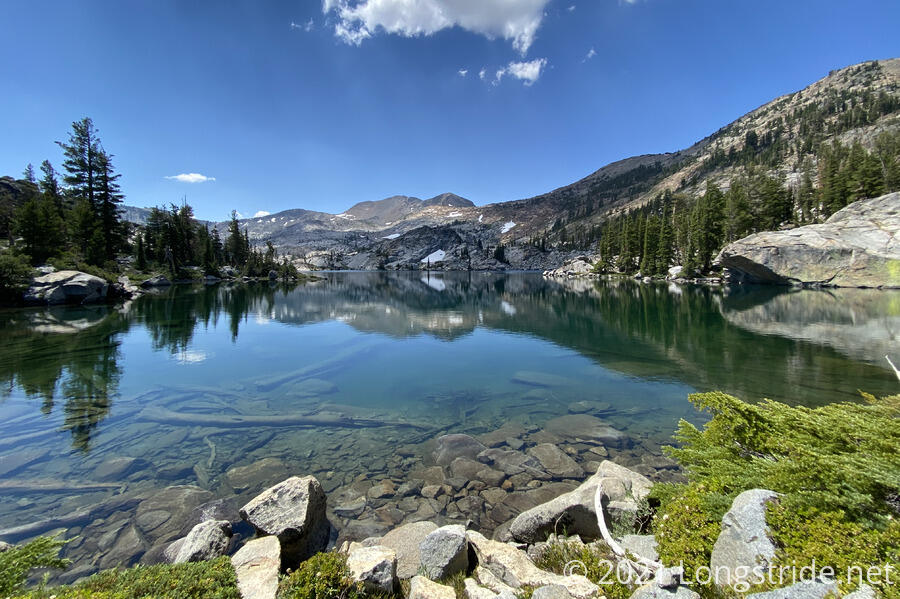
Lakes are one of the key defining features of the Desolation Wilderness, besides the stark rocky landscape. Just as we passed no shortage of creeks and lakes on our way up to Dicks Pass, the way down provided us with a great number as well.
In contrast to the somewhat rocky ascent, the hike down the north side of DIcks Pass was much easier, with the trail more substantially on dirt than rock, and there was more plant life. The “desolation” seemed largely confined south of the pass, but there were still plenty of stark areas to be found.
Eventually, we stopped at Middle Velma Lake for a snack break, and to collect water so we could dry-camp this evening. With our distance goals in mind, Richardson Lake would have been the obvious place to stop, but given my experience there in 2018, I didn’t want to camp there. So, we decided to cut the planned distance for today a little short, which would also work with cutting tomorrow a little short so we can avoid camping near a creek with a problem bear on our last evening on trail.
Although there was a steady stream of hikers that passed our snack spot, it was quiet, calm, and peaceful. And also well shaded.
Shortly after we left from our break, we passed a group of four hikers returning to Middle Velma Lake to take a swim — they’d passed by a few minutes earlier and thought they’d be able to get to the water from a little further up the trail, then realized they couldn’t. One of them was carrying a guitar on his back; CareFree commented on his playing at Susie Lake last night; he said he didn’t realize there were hikers camped where we were!
Once we passed Middle Velma Lake, I didn’t recognize much of the trail. This wasn’t very surprising, since by now, the trail had entered the forest proper, and there weren’t a lot of visual cues.
Around 1:30, it started a very light drizzle, and 15 minutes later, we put on our pack covers, as the drizzle showed no signs of stopping grand instead started becoming a proper light rain.
Later, after the rain stopped, we passed by the girl from our bus from South Lake Tahoe, and stopped to chat with her a bit. At the same time, a PCT thru-hiker wearing a Colorado Trail hat passed the three of us. We had been constantly leapfrogging with him, and I just had to comment about that. “Some days are just like that,” he said, and then joined our conversation.
Around 3 pm, we stoped at a campsite alongside the trail, meeting our abridged mileage goal for the day, and had a relaxing afternoon.
After we set up camp, an older couple, whom we met at Echo Lake, and with whom we’d been leapfrogging yesterday and today and having brief chats with, arrived, and stopped briefly for another chat. They told us they’d just passed a rattlesnake crossing the trail. It made us realize that, so far, we had not yet seen any snakes at all on the trail!
As we relaxed, the clouds, which had been looking vaguely ominous since we arrived at our campsite slowly grew darker. I’d been putting off starting dinner because, for the previous half hour, it looked like it was going to start raining in about five minutes. Finally, I got tired of waiting, and figured I’d give the weather a helping hand. I got everything ready for dinner, and about thirty seconds after I started water boiling for my macaroni and cheese course, a crack of thunder rang out. A couple minutes later, a few raindrops started to fall, and CareFree and I relocated so that we could sit inside our tent while it rained.
The rain conveniently stayed a very light drizzle until my mac and cheese was done, and then it started raining harder for about the next 45 minutes. The rain then slowed to a trickle a few times only to resume, then stopped for long enough for us to finish cooking,and then poured for a good half hour.
Once the thunder and rain finally stopped, it was noticeably cooler. We hoped this would continue on until tomorrow: it’s a lot easier to hike in cooler weather.