The unofficial motto of the Continental Divide Trail is “Embrace the Brutality”. My first long-distance hike was the Appalachian Trail, which is brutal in its own way, so I was resistant to viewing the CDT in those terms. The AT is a physically very challenging trail, and has more elevation gain than the CDT in fewer miles, so just how brutal could the CDT be?
A Trail of Extremes
The CDT is not (just) a physical challenge. It’s a mental one. That is, of course, true of any long-distance trail. But it was the CDT that brought me closest to wanting to quit the trail.
So what made the CDT so challenging?
Before I started my hike of the Continental Divide Trail, another hiker I knew who’d completed the CDT in 2018 told me that the CDT was a trail of extremes.
He was right. And that’s what makes the CDT brutal.
Nearly every section of trail went on just a little too long, with impressive scenery fading into repetitive sameness, before the abruptly changing into something completely different (that then also overstayed its welcome).
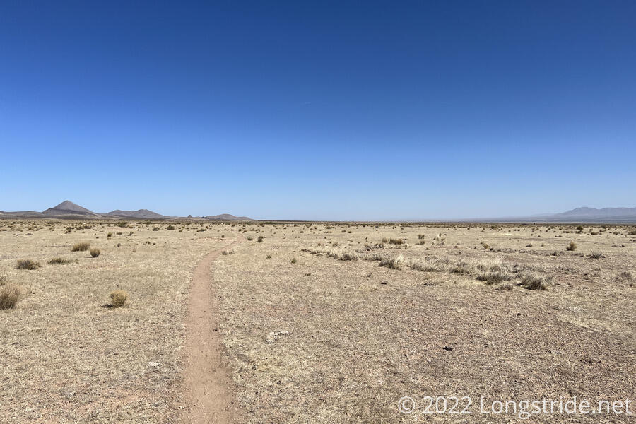
New Mexico
The southernmost section of the CDT, from Crazy Cook to Lordsburg, was the driest trail I’ve ever hiked. Fortunately, it was only four and a half days long. Half a week further north, I hiked through the Gila River. With nearly 250 river crossings, it was easily the wettest stretch of trail I’ve ever hiked.
Most of the rest of the trail to Grants was a sub-desert sameness, and a few mountains aside, a very flat stretch of trail.
New Mexico wasn’t hard. Nay, it was almost the flattest, easiest state I’ve hiked on any long-distance trail. What was hard was the sheer quantity of unshaded road walks.
Colorado
The unseasonably warm temperatures in southern Colorado and northern New Mexico meant that everything there was drying out. That was great for hiking Colorado, which had somewhat low snow only because much of it melted away before I got there. (There was still enough to cause problems, but I generally wasn’t postholing every day like I did in the Sierra.) It was bad for New Mexico, because the trees in the forests were so dry (supposedly, a matchstick had higher water content by weight than the trees) that the US Forest Service closed all the National Forests in New Mexico.
That combined with a snowstorm in southern Colorado caused many of the hikers I was hiking with or near to take a week off in Albuquerque, before skipping up to Chama. After six days of not hiking at all, in less than 24 hours, I jumped from 5,300 ft in Albuquerque to 10,000 feet at Cumbres Pass to continue hiking, without the benefit of hiking that elevation change and gradually acclimatizing ourselves. (It didn’t help that I probably caught Covid while in Albuquerque, so not only was I hiking at altitude without working my way up, my body was fighting a virus which, among other things, makes it harder to breathe. Talk about doing it the hard way!)
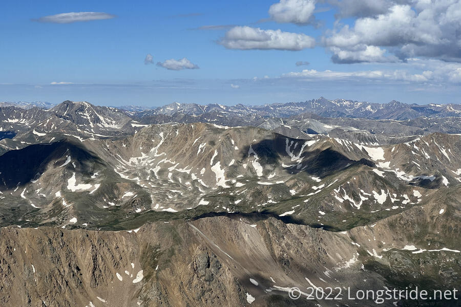
Colorado was a constant, tiring, bouncing up-and-down the mountains, gradually wearing me out. Mount Elbert and Grays Peak were arduous to summit, though I can’t for one second complain about the amazing views they offered. The views were all good, but there was a lot of sameness: peaks with snow, gradually decreasing as it got later in the season; not many trees at elevation, and occasional large burn areas or dead forest due to bark beetles. (Forests of dead trees are usually not very epic.)
Colorado actually was properly hard. Exhausting, even. It was my slowest state, and taking as long as it did set me up for a bad time in Wyoming.
Wyoming
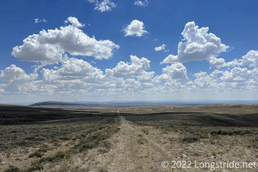
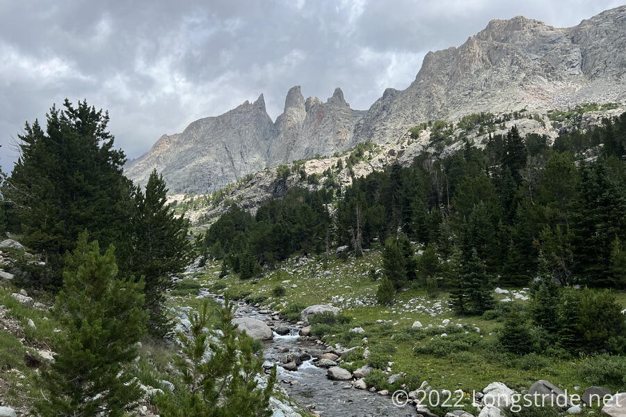
Wyoming took extremes to an extreme. After nearly 800 miles through high-elevation mountains in Colorado, Wyoming quickly became quite arid, and largely flat. The Great Divide Basin was the moroadwalkonous section of the CDT, with the trail largely following a series of very straight dirt roads through a hundred miles of sagebrush and cow pastures. Then, the trail became mountainous again, going through the stunning Wind River Range (and the self-inflicted but amazingly beautiful hardship of the Cirque of the Towers alternate). Beyond that much more mild trail and scenery gave way to the active hot springs and geysers of Yellowstone, a unique treat on the trail.
In Wyoming, I definitely saw more cows than people. A few times, they were a nuisance. The cows definitely got old very quick. (Though, I will have to admit, there’s probably more water available to hikers in New Mexico and Wyoming than there otherwise would be if ranchers didn’t have cows to keep hydrated.)
Wyoming wasn’t hard. What was hard was days of following a straight dirt road through an unending desert basin with cows everywhere and unchanging scenery. What was really hard was the pressure of the weather window starting to run out and having entirely too many miles still to go.
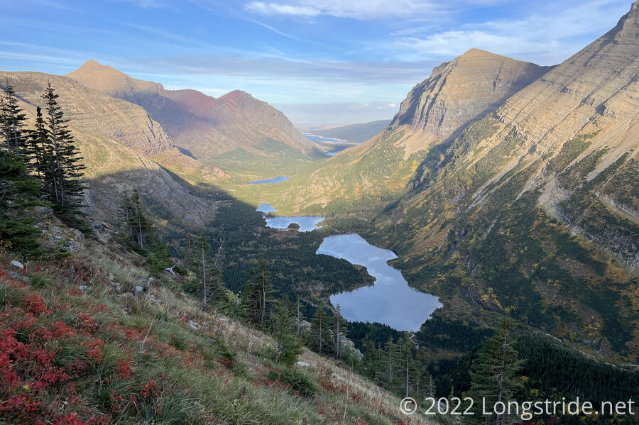
Montana
Montana generally was more mild and diverse, though the trail very much felt like four distinct sections: a rapid cycling between mountain trail and basin roadwalk that was the shortcut from West Yellowstone to Butte, which included a few days with a 100+ °F heat wave; the sometimes rugged mountain trails to Augusta; the Bob Marshall wilderness largely dominated by burn scars; and Glacier National Park, with unparalleled rugged glacial topography that was easily the best several days of scenery on the trail.
Montana wasn’t hard. What was hard was being off trail for a 200 mile shortcut because the weather window was closing and time was running out, and rushing to Canada to “finish”, only to not actually be done.
New Mexico Redux
Once I reached Canada, I returned to New Mexico to finish the section I had to skip due to fire closures, trading the cool green trail in the north for northern New Mexico’s desert, interspersed with a couple of mountain ranges. This section had some of the most interesting views in New Mexico, and (for the first couple of days) incredible scenery as the aspens started to change colors, seeming to bathe the landscape in a yellow glow. That quickly faded away to desert scrub as I approached Ghost Ranch, which has its own unique sandstone landscape, changed back to forest on the way to Cuba, and returned to a completely different desert landscape dotted with buttes between Cuba and Mount Taylor.
The last two nights on trail were beset with overnight precipitation, leading to a comically muddy road on the penultimate day on trail, and snow on the last day, leading to a long road walk into Grants to complete the trail.
New Mexico continued to not be hard. What was hard was continuing to hike for two weeks after “finishing” the trail.
Trail Maintenance
As a whole, the trail itself was actually very well maintained, especially given its remoteness in Colorado. I have very few complaints. The trail tread was generally fairly nice. Where there were maintenance problems, though, they were pretty big, and usually coupled with another complication.
In southern Colorado, a few extensive rugged stretches of blowdowns (which did not mix well with snow). In Wyoming near the Cirque of the Towers, blowdowns did not mix well with rain. In Montana, just south of Glacier National Park, an incredibly tangled stretch of blowdowns so bad it earned the name “Devils Jungle Gym” and resisted cleanup efforts — a trail crew had worked clearing the deadfall for a week and didn’t get it all cleaned up because they ran out of time. This last stretch of trail was my slowest on the CDT.
Embrace the Beauty
Accepting that the CDT is a hard trail and that you just have to suffer through it is certainly one way to rationalize your way through the difficulty of the trail. But I don’t think it’s a great one. I never embraced the brutality of the CDT. The trail is what it is, and being poetic about how hard it is is just a distraction for the beauty the trail has, if only you look for it.
Next: CDT Thru-Hike Statistics