Today was a great day of views and variety, as we advanced south along the east side of the Lake Tahoe Rim.
CareFree and I got off to a somewhat late start today, a little before 8 am. Already, several other hikers had passed us while we were eating breakfast and packing up to leave.
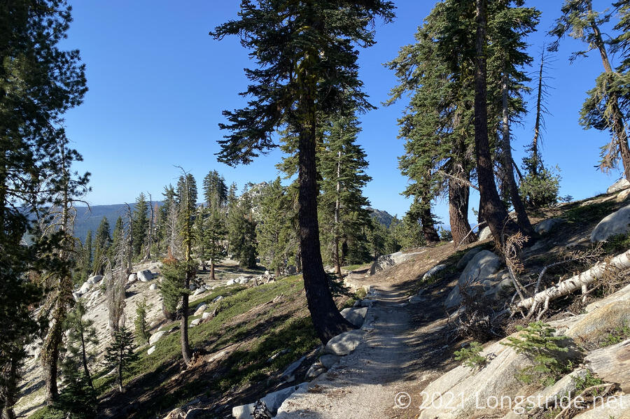
The morning’s trail took us along the ridge, heading south along the eastern side of Lake Tahoe. There were mostly views to the east, towards Washoe Lake, and one viewpoint gave a view both to the east, and the west, towards Lake Tahoe. We also saw a ski lift (not in operation) that leads partially down the mountain to Incline Village.
On our way down, we saw two trail maintainers repairing a section of trail. It’s always a treat to see the people responsible for keeping the trails we hike hikeable.
About half an hour later, we entered the Lake Tahoe Nevada State Park, which does not allow camping except for the two campgrounds we will visit: Marlette Campground for water for the day, and the North Canyon Campground for camping this evening.
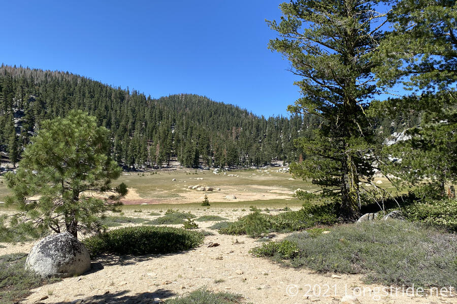
We took a short break under a tree just after entering the park, and found someone’s lost tent stake lying on the ground. A little further in, we saw a bowl-shaped depression with large rounded boulders. We suspected this was once the site of a lake, now long dried out.
The trail through the park was a notable change in character from the trail behind us, featuring more boulders, sandy ground (as opposed to dirt), and fewer trees. It was still pleasant hike through; it was a nice change of scenery, since it can get a little boring hiking through the exact same landscape for an extended period of time.
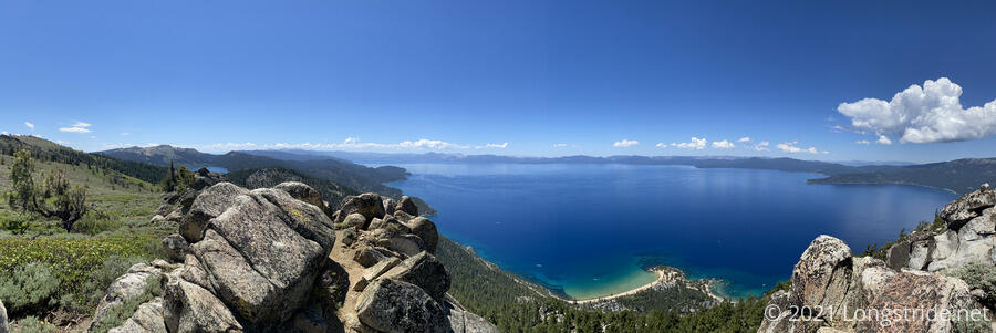
We decided to take a half-mile side trail to a view, “Christopher’s Loop”. On the way, we finally got word about our Desolation Wilderness permit, which had been approved after some machinations by a representative of the Lake Tahoe Basin Management Unit, after my earlier requests seemed to have somehow gotten lost in the system (and the whole thing complicated by that we were now already on-trail). That happy news allowed us to stop worrying about the permit.
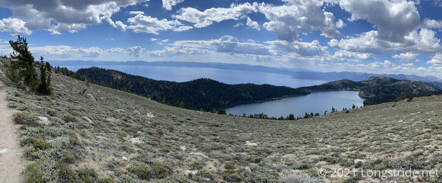
Christopher’s View gave us a stunning view of Lake Tahoe, looking almost directly down to Sand Harbor Beach, and again giving us fantastic colors from the lake. We could also see Marlette Lake in the distance, some 1500 feet above Lake Tahoe.
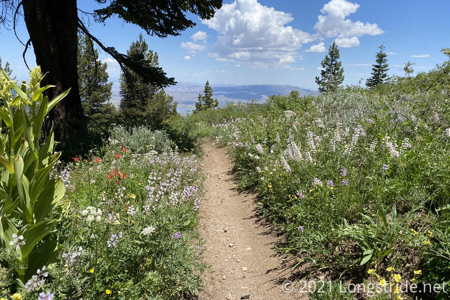
Once we made our way back to the Tahoe Rim Trail, the trail took us through a bald, covered in small shrubs and wildflowers, with only the occasional tree. As we made our way through the bald, we ran into another hiker wearing a blue hoodie, who was doing the TRT in short sections; as he put it, he’s a hiker, not a backpacker.
Our next stop was the Marlette Campground to make use of the pit toilet and water pump there. There will be water at our destination tonight, but we still needed water to get there. Getting there involved a detour along an alternate route, a little to the east of the TRT, on the other side of Marlette Peak. As we dropped off the bald to lower elevation, the flowers alongside the trail grew in number.
The water pump at the campground was a bit awkward for one person to operate, requiring both pumping the handle and holding your water bottle under the spigot, while trying not to spill too much. Two people made it much easier to manage. It was potable water in a section of trail with very little, though, so it’s not like we’re complaining.
Leaving the campground, we continued hiking south, heading towards another bald mountain. After an hour, we stopped for a break. While there, a hiker with a very large backpack came running down the hill ahead of us. He said he needed to make it to Ophir Creek, some 15 miles behind us. It was unclear how far he’d already come, but (at a slight running pace) we figured he still had another four hours to go. With it being 3:15 already, he still had a long day ahead, though mostly downhill.
CareFree also discovered a blister on the back of her foot; I gave her a band-aid that had probably been in my pack since my Appalachian Trail hike five years ago.
Leaving our shaded break, we finished the steep portion of our climb (almost 700 ft/mi, more than twice as steep as the trail average), climbing up to the bald and being treated with another great view of Lakes Tahoe and Marlette.
Finished with the climb, we descended along the side of the mountain, to a long, unobstructed view of Lake Tahoe.
It was clear why the area was a no-camping zone. The fragile alpine plants would stand no chance against the sheer number of people who would attempt to camp on the bald for campsite views.
We reached the side trail to the North Canyon Campground, and were a bit bemused to find two perfectly good campsites right at the trail junction. It would have been very tempting to camp there, but we didn’t have the water to do so, so it wasn’t even a consideration for us.
Though a sign at the junction advertises the campground as 1.2 miles away, it was closer to 1.4 miles, making it the furthest off-trail I’ve gone to camp since Whitley Gap Shelter on the AT. The campground has maybe half a dozen sites with bear boxes, picnic tables, and (closed) fire rings; a pit toilet, and a very nice and cold well-flowing creek for water. It’s also along a dirt road that goes between Marlette Lake and Spooner Lake, a few miles ahead. As campsites go, it’s pretty good, except for the distance from the trail.
The hiker in blue was also there, and we learned he had been at AlpenGlow in Tahoe City at about the same time we were, since he was there for when the three hikers we met there that had the bear encounter were talking about it.
We generally thought that today was our favorite day on trail so far, despite the campsite far off trail (and downhill, which CareFree especially did not appreciate), due to the huge variety of landscapes and views today.
Tomorrow is going to be a tricky day for water, and it looks like we might need to carry enough water to get us to town in two days. After here and Spooner Lake in a few miles, the next reliable water source is shortly before we reach South Lake Tahoe.