A second day in the Longwood Forest took me through extremely muddy trail to the final hut on Te Araroa.
Overnight, it rained from just before midnight to sometime after 4 am. It seemed like a lot more rain than the weather forecast yesterday suggested. But then, it’s hard to tell just how much it’s rained from the sound of rain on a tent, because tents tend to amplify the sound of falling raindrops. In any case, there were puddles on the gravel road where there weren’t yesterday, and as expected, my campsite on top of the berm next to the road was relatively dry. The cold I had yesterday was improved significantly, though it’s not completely gone yet, and I still felt its draining effect throughout the day, particularly on the uphills.
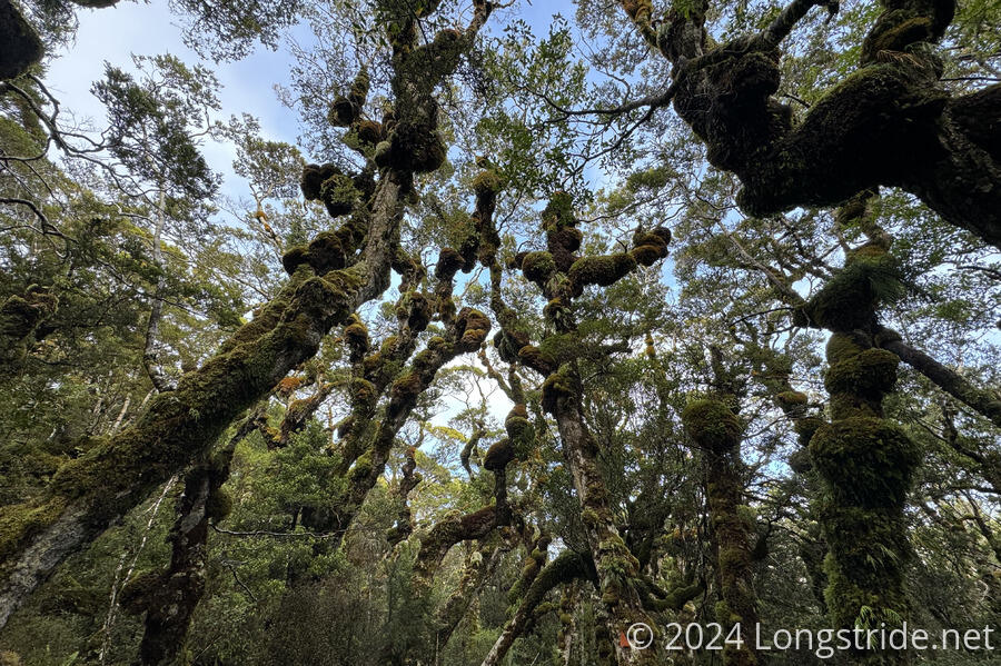
After crossing the quarry, the trail began climbing through the forest towards the Little Baldy summit. The descent down the road yesterday didn’t lose much elevation compared to the climb up to Bald Hill, so on the way up from the quarry, it didn’t take long before the trees became short, stubby, and gnarled.
It took some effort, but I was able to keep my feet from getting too wet on the way up. Most of the water issue was runoff down the trail from the rain overnight. There was the occasional mud puddle, but as with yesterday, there were plenty of side paths around the muddy sections of the trail.
Near the top of Little Baldy, the forest gave way to short shrubs and tussock. I was able to see back to Bald Hill. Ahead, I could barely see Bluff; the clouds and sun glare made it hard to pick the hill out from its surroundings.
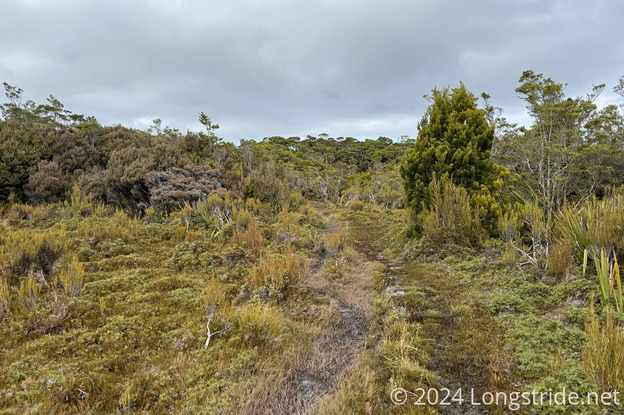
The slowest, and muddiest, part of the day was the saddle and ridge between the Little Baldy and Longwood summits. Between very soggy ground thanks to the rain, and places where it wasn’t possible to go around the mud pits, eventually my feet got soaked, and my boots were completely covered in mud. After that, I wasn’t too much worried about keeping my feet from getting more wet, because there was no chance for anything to dry, but I still tried to avoid the mud pits as much as possible. There was no telling how much water would be in them, and I didn’t want to get in too deep to easily get out, or else hurt myself making a step that didn’t go as expected. It’s easy to get hurt when you can’t see what your feet are going to be stepping on. In spite of being careful, I still managed to step into the mud up to my knees, and thanks to my poles, I know I avoided mud even deeper than that.
The worst of the mud ended once the trail climbed up above the forest, into the extended bald area around the Longwood summit. For much of that, the trail was a creek, but at least then it was possible to see where I was stepping, or else walk on the path through the grasses that had formed next to the trail.
I’ve been impressed with how well the trail was marked in the Longwoods. In the forest, there were arrows nailed to the trees everywhere, and easily more than half the time, there was an arrow (or several) in view. On the exposed ridges with no trees, there were numerous poles. They were a bit short for my liking, given the height of the bush, but there were enough of them that the next one was almost always in view. (This was in stark contrast to the minimal markers in the swampy areas along the Mavora Walkway or around the Takitimu Forest.)
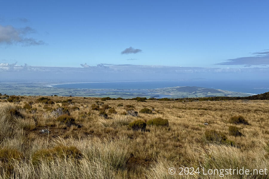
From the area around the Longwood summit, I had more hazy views towards Bluff, and clearer views to the beach along Te Waewae Bay on the west coast, which the trail does not go near.
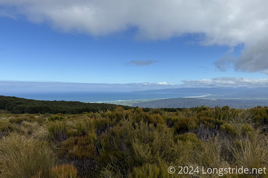
The mud abated significantly around the Longwood summit, and this was a reasonably nice part of the day, especially with the view to the ocean. I had good views until the trail began a steep descent back into the forest.
Once back into the forest, the mud began to become problematic again. Between the mud and the steepness (and the climbing over wet trees), this was annoyingly slow, but eventually, I reached Martins Hut, my original planned destination yesterday. This took just over six hours from the quarry. It’s hard to tell if it would have been faster yesterday, with less water; I’d have been more tired due to my cold. But I’m glad I didn’t try and go this far yesterday, since I would have had to night-hike to get there, which would have been awful. (I didn’t see any campsites along the way, either.)
I stopped for a break at Martins Hut, then continued to Turnbull’s Hut, the final hut on the TA. From Martins Hut, the trail followed Turnbulls Track, adjacent to a water race the entire way. This kept me on my toes. Usually it was fine, but occasionally the trail narrowed, and I had to take care to not step into the watery ditch, which was occasionally deep, or filled with branches.
The trail crossed a few creeks, and I took the opportunity at one of them to clean the mud off my legs.
After about two and a half hours from Martins Hut, I reached Turnbull’s Hut. Especially with the rain last night, the entire area in front of the hut was muddy. This made it a little challenging to get to the trail magic next to the hut: three coolers filled with soda, beer, and some fruit, courtesy of a trail angel.
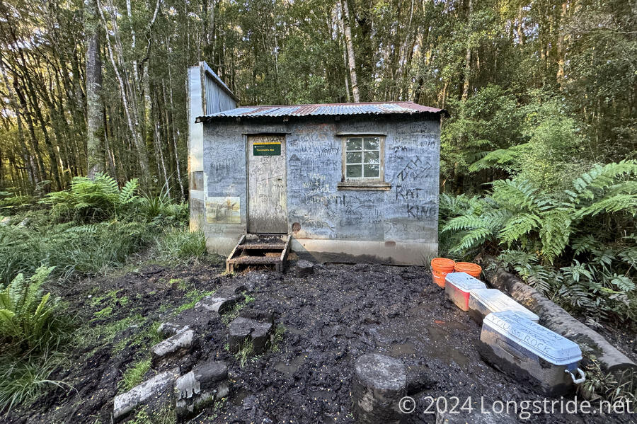
Turnbull’s Hut is a small, historic two-bunk hut. It was not quite in as much of a state of disrepair as West Harper Hut in the section before the Raikaia River, but it definitely showed its age. The dirt floor was uncovered, and very uneven, so care was necessary to walk around in the hut without tripping on the floor. The two bunks were a bit higher off the ground than usual, and the logs placed to make it easier to get up or down were quite wobbly. There were numerous holes in the walls and roof, and the hut was quite drafty. Fortunately, though, it was still enough to keep the rain out: a light rain started shortly after sunset, and continued well into the night, gradually gaining in intensity. I hadn’t planned on staying here, but I had the place to myself and it was much nicer than pitching my tent in the rain.
Tomorrow will see me through the end of the Longwoods, out of the last mountain and forest on the TA, and out along the southern coast of the South Island, as the end of the trail draws near. There is now less than 100 km to go!