Last year, I completed a thru-hike of the Tuscarora Trail, along with a stretch along the Appalachian Trail to form a loop. And while both the Tuscarora’s northern and southern termini are on the Appalachian Trail, and the Tuscarora goes through the Appalachian Mountains, those two trails could hardly be more different.
Part of why it took me so long to write this post is that the Tuscarora is a hard trail for me to like. To an extent, the Tuscarora is largely what I expected: remote, isolated, and with few people. But it’s a difficult trail to thru-hike because of the challenges presented by the trail’s location and design.
People on the Trail
The Tuscarora is both a less-well-known trail, and somewhat remote, so I didn’t expect to see many people on the trail at all. Further, I expected there would be days where I saw nobody else.
My experience largely matched my expectation: there were relatively few hikers on the trail, and, I only met a handful of other people who were attempting to hike the whole trail (though, no one that was thru-hiking). However, much to my surprise, every day I was on the trail, I saw at least one other person.
Campsites, or Lack Thereof
A somewhat similar tail to the Tuscarora is the Benton MacKaye Trail, located in Georgia, Tennessee, and North Carolina. When I thru-hiked the Benton MacKaye Trail in 2018, I came away with the impression that it made a quite reasonable alternate to the Appalachian Trail.
Like the Tuscarora, the BMT is more remote than the AT. The BMT aims at being a more “wild” experience than the AT, and this partly manifests by the BMT having few campsites and only two shelters (one of which seemed placed explicitly to compensate for a lengthy no-camping zone). The BMT can only carry a small number of overnight hikers, because its designers intentionally did not set aside space for large number of hikers to camp. And this is part of the BMT’s charm.
By contrast, the Tuscarora does have plenty of shelters (and hikers are encouraged to use them), and with only a couple of exceptions, they are reasonably well-spaced. In fact, there are several very nice shelters that seem almost too good for the trail (and are palatial mansions by AT standards), given the relatively small number of hikers on the Tuscarora. And since there were few other hikers on the trail, I had the shelters (and campsites) to myself every night.
What the Tuscarora lacks, though, is campsites. This is because a large portion of the Tuscarora is on or adjacent to private land, where no camping is allowed. This means that hikers generally must hike shelter-to-shelter, which in a couple of cases forces some relatively long days.
Remote Country Roads
The intense patchwork of private land ownership around the Tuscarora Trail also manifests in some rather extensive road walks. There’s at least 47 miles of paved roadwalk on the Tuscarora (almost a fifth of its total length), including a 14 mile stretch in West Virginia, some of which had very narrow shoulders. There’s easily another 40 miles of gravel and dirt roads, which makes nearly the entirety of the trail in Maryland “on road”.
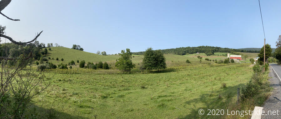
Roadwalks do have the benefit that it’s generally easy to keep a fast pace, but they are typically also quite boring, and pavement and asphalt are much harder on the legs and knees than dirt. And occasionally, you do get nice landscapes.
Water
The Tuscarora is a somewhat dry trail. This should not be surprising, since it spends a lot of time on the top of mountain ridges. But it does make hiking the trail somewhat inconvenient. Water is heavy, so naturally, I’d prefer not to have to carry more than necessary. But there were a couple of days where, had I not lucked out by running into trail maintainers who offered to plant water caches for me in two places, I would have had two days where I would have had very long water carries, one of which would have been over very rough and rocky terrain.
Where it existed, water quality on the trail was wildly inconsistent. Reese Hollow Shelter in Pennsylvania had a beautiful crystal-clear spring flowing just off to the side from the shelter. Shockeys Knob Shelter in West Virginia had some of the most difficult to collect water I've ever collected, and it smelled so bad that I had to filter it three times before it seemed edible. Most other water sources fell somewhere in-between.
Maintenance
The trail in Virginia and West Virginia was mostly well-maintained, and there were only a few areas where the trail was overgrown and a nuisance to hike on.
In Maryland, a little more than half the trail is the C&O Canal Tow Path. The rest of the trail in the state is either paved or gravel road. This made the need for maintenance in Maryland almost nonexistent.
Pennsylvania, though, had very uneven maintenance; some areas were very well maintained, while others were very poorly kept. Most likely, Covid restrictions in the first half of 2020 caused the shortfall of maintenance in Pennsylvania. It didn’t help that these areas of low maintenance also coincided with some of the most rugged areas on the trail, and there were places in Pennsylvania where I struggled to maintain one mile per hour.
Views
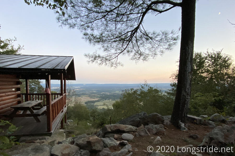
With the exception of Maryland, every state on the Tuscarora had great ridge-top views. Virginia had the best view at a campsite, in the George Washington National Forest on Little North Ridge Mountain. In Pennsylvania, the Charlie Irvin Shelter had one of, if not the best view of any shelter I’ve ever stayed at, overlooking the Cumberland Valley and providing a fitting place to spend the last evening on the trail.
I wasn’t counting, but Pennsylvania felt like it had the largest number of views.
Other Thoughts
In terms of gear malfunctions per mile, the Tuscarora Trail was my worst. At the end of my second day on trail, the internal frame on my pack broke (leading to hiking for two days with a sharp rusty metal rod poking into my side), though in fairness to the Tuscarora, that happened on the AT section of my hike, and the pack already had 5400 miles on it by that point. The first day in Pennsylvania snapped one of my poles in half, but that did allow me to finish the trail with a nice souvenir; the next day, I found a nice branch, and completed my hike with one pole and a hiking staff.
The AT sections of my loop hike went largely as I expected, and I don’t really have much to add I didn’t already cover in my hike journal. On balance, was nice to revisit that section of the AT again. Being out of hiking shape (and with it hot and high humidity), the Roller Coaster section of West Virginia was brutal. Going into Shenandoah “backwards” was very weird, and I did not recall a substantial portion of that part of the AT from my 2016 thru-hike. I was disappointed that the Washington Monument in Boonsboro, MD was (understandably) closed due to Covid.
Future Plans
The Tuscarora wasn’t my favorite hike, but, on the whole, I had a good time. While I doubt I’d hike the whole thing again, there were a couple of places I wouldn’t mind revisiting. There seemed to be a lot of interesting trails in the George Washington National forest in Virginia and West Virginia, and it would be fun to explore those. Also, I have in mind a thru-hike of the 71-mile Massanutten Trail, which circles the ridge of Massanutten Mountain. (The Tuscarora loops around the north end of the mountain.) That might be a good shakedown hike for my twice-delayed but upcoming Continental Divide Trail hike.