Just under a year ago, I finished my thru-hike of the Continental Divide Trail. The CDT was both everything I expected it to be, and yet, nothing like I expected.
It’s difficult to compare trails to each other. While every trail has some similarity to some other trail, each is different and unique in its own way. Still, after having hiked seven other long-distance trails, I felt I had a good handle on what to expect from the CDT. There would be differences, of course, but I had a good baseline, or so I thought.
Over the next few days, I’ll share some of my thoughts on the CDT, and how the trail compared to my expectations.
On Top of the World
Roughly following the Continental Divide, the CDT is a high-elevation trail. Its low point, just under 4,200 feet, is along a roadwalk just north of Lordsburg. Once above 5,000 feet, the trail doesn’t drop below that elevation again until Glacier National Park, near the northern terminus, and spends nearly all of Colorado above 10,000 feet. The CDT’s routing goes high, and stays high, as long as it can.
In contrast, the high point of the Appalachian Trail is at just 6,600 feet, and most of the AT is below than 4,000 feet. As a result, most of the CDT higher than all of the AT. And while the Pacific Crest Trail in 2018 does have some excursions at high elevation, it’s only during a roughly 400-mile stretch through the Sierra that the trail climbs above 10,000 feet, and even then, it’s not consistently at that elevation.
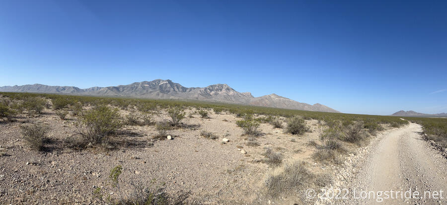
Nearly immediately, the CDT’s altitude made its mark. In New Mexico, the trail starts in a high-elevation desert. Thanks to a lack of trees, and visibility for miles, the (relative) lack of prominence of the nearby mountains over the trail, and with the somewhat brighter and harsher sun (compared to sea level on the east coast) gave me the feeling of being “on top of the world” as early as my second day on trail.
As a aside: one of the weird things (to me) in the Chihuahuan Desert, where the CDT starts, is that there were places where, due to how much wide open space there was, you could actually see the ground gradually slope away from the nearby mountains. In my prior experience, there were usually too many trees to get that sort of view (or else, a much steeper and more obvious drop that no forest could hide).
Over its length, the CDT spends a considerable time on or near the tops of ridges — much like the AT. This afforded me the opportunity to summit 38 mountains. (That’s far short of the 290 mountains I crested on the AT, but still better than the PCT’s grand total of zero on-trail and six off-trail summits.)
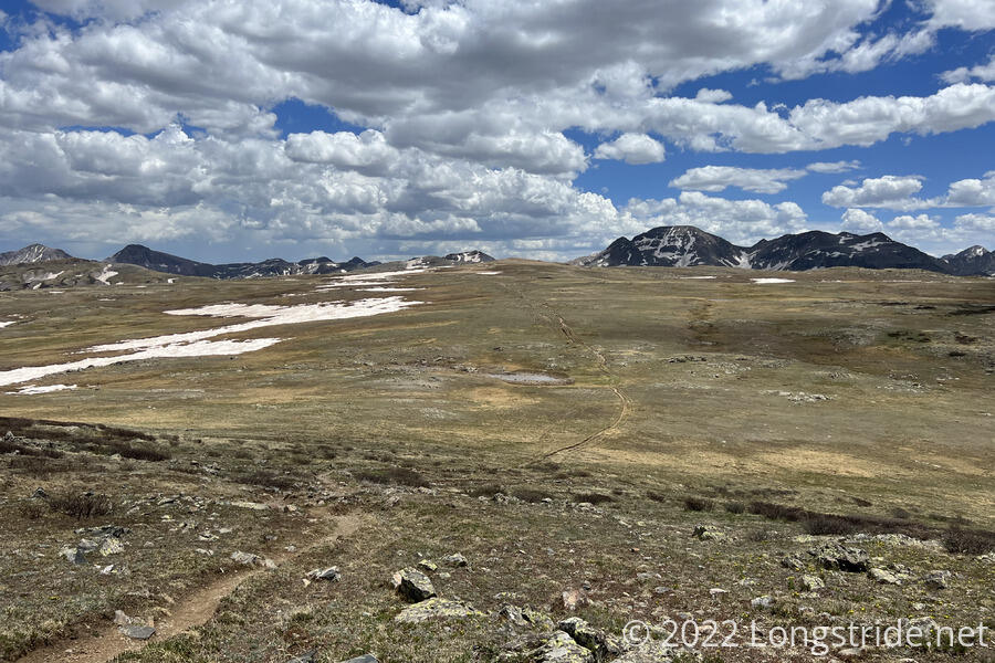
This was particularly evident in the San Juan Mountains of Colorado. The San Juans are particularly noted for their high-elevation peaks and plateaus. There were still plenty of (occasionally steep) climbs to cross over passes, but individually, the climbs were never that long or that far below their passes. In that regard, the CDT in Colorado is a lot like the AT: many relatively short ascents and descents. The PCT, in comparison, had multiple twenty-mile long ascents and descents (such as the descent from San Jacinto to the valley floor and ascent from Cajon Pass to the outskirts of Wrightwood. On both the AT and CDT, a hike like that would very quickly run out of mountain.
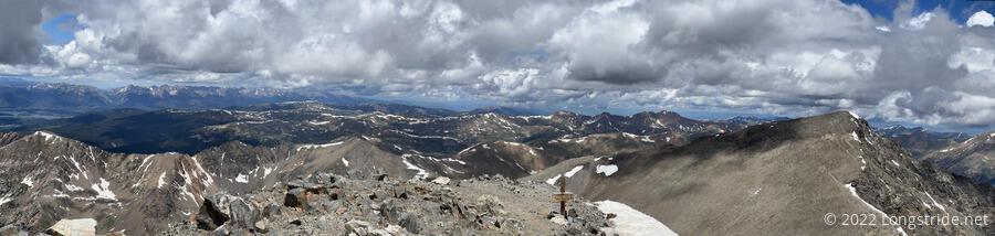
But where the CDT lacks in quantity of mountain summits, it makes up for in elevation. I summited my first mountains above 11,000 feet, 28 in total, including four fourteeners, six thirteeners, and twelve more above 12,000 feet.
Besides the trail’s high point on Grays Peak (14,270 ft) in Colorado, detours took me over my first fourteener, San Luis Peak (14,014 ft); Mount Elbert, the highest peak in Colorado, and the Rockies, and second-highest in the continental US, about 400 feet shorter than Mount Whitney; and Torreys Peak (14,267 ft, adjacent to Grays). These were not easy climbs, and especially going up Elbert, I could feel the altitude sapping my strength. Still, all of those summits came with absolutely amazing views I’ve never had anywhere else, and it was worth all the hardship.
The CDT’s habit of often being on or just below a ridge aided the perception of being on top of the world. In contrast (and despite its name), the Pacific Crest Trail rarely was on top of anything. The AT does spend a larger portion of its distance on top of ridges than the CDT, but that’s often hard to tell. On the AT, tree cover doesn’t do wonders for sight lines, and it’s pretty rare to clearly see where you’ve been or where you’re going.
While great for views, the CDT’s high elevation frequently put it above the tree line, making the trail frequently exposed to the sun (and causing me to run out of sunblock a few times!). It’s been a few years since I was on the PCT, so it’s hard to remember precisely, but my general impression was that the PCT felt like it was more shaded than the CDT. Whether that’s because the PCT had more trees, or because the trail spent more time deeper in valleys, thus affording more shade from the mountainside, is hard to say right now. (Clearly, I’ll have to go back and hike the PCT again to refresh my memory!) Exposed or not, the CDT’s relatively higher elevation than the PCT did mean that the sun was a bit harsher, especially in Colorado, and the Great Divide Basin, part of the high-elevation Red Desert in Wyoming.
Even though the CDT’s views were often incredible, the landscapes tended to have a sense of sameness that I just didn’t feel from either the AT (despite its green tunnel) or the PCT (which felt like it had a far larger variety of scenery).
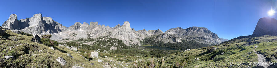
In Wyoming, the CDT lost its feeling of being “on top”. The Great Divide Basin was not quite a desolate, featureless plain, but one could be forgiven for thinking it was. And in the Wind River Range, the official trail conspicuously stays in the range’s western foothills. The crown jewel of the Winds, the Cirque of the Towers, is very much the opposite of “on top”: that alternate takes you to the head of a glacier cirque so you can be surrounded on all sides by towering granite peaks.
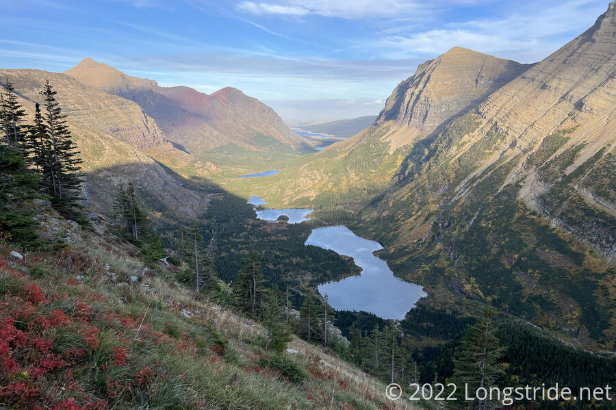
In Montana, the somewhat lower elevation put the trail below tree line more often, increasing tree cover. Glacier National Park didn’t disappoint, though, and was one of the few places where the trail was close enough to the eastern edge of the Rockies to be able to see the Great Plains to the east, most notably during the climb up Swiftcurrent Valley.
The CDT’s unique location made for some impressive scenery I’ve not seen elsewhere on trails in the US. But its location also meant that water — in all its forms — was a real concern.
Next: Water and Weather on the CDT.