On the north-eastern slopes of Mount Taranaki, one of New Zealand’s most iconic volcanoes, lies the Veronica Loop Track. An easy-to-moderate tramp 4.5 kilometer loop through lush rainforest, this trail provides excellent views of the lowlands surrounding Taranaki, with occasional views to the mountain’s summit.
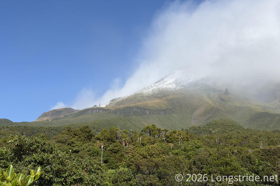
Located in Te Papa-Kura-o-Taranaki (formerly Egmont National Park), a national park close to the North Island’s west coast, near New Plymouth, Mount Taranaki is a dormant volcano and the second-highest mountain on the North Island. Taranaki is notable for its isolation and almost perfect conical shape, rising 2,518 meters above sea level, and surrounded by a flat plain of farmland from its base to the ocean.
We originally planned on hiking to Taranaki’s summit today. Though a bit late in the season as New Zealand’s winter approaches, we still had the possibility of good weather. But an unexpected day of rain yesterday and leftover clouds left a significant area below the summit blanketed in snow, and high winds made an ascent above the tree line challenging, to say the least.
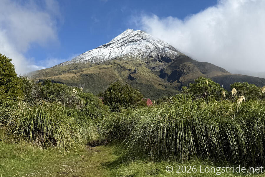
So instead, we opted to walk the Veronica Loop Track, starting from the North Taranaki Visitor Centre. (The visitor center is currently a temporary trailer, as the main building has been demolished and is in the process of being rebuilt.) From the parking lot, there is a relatively good view towards the mountain’s peak (and also a radio tower that provides FM radio for the region), though clouds initially hampered that view. The wind blew strongly, making it a little cool to be standing around outside not actually hiking.
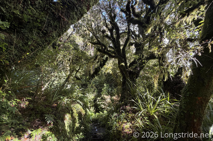
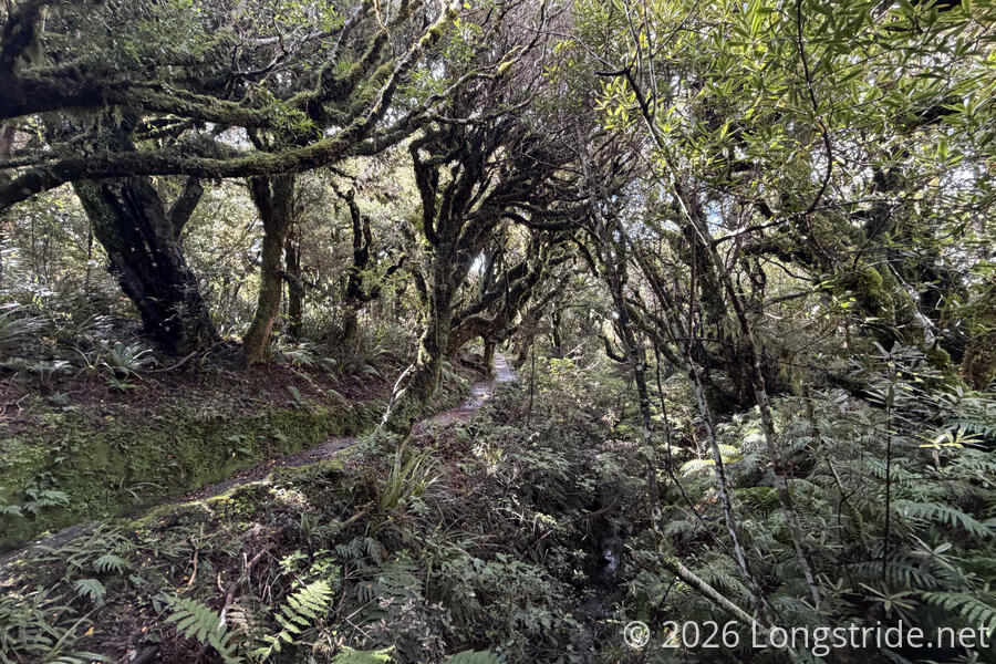
From the visitor center, we headed west, initially on the Ram Trail. Immediately, we entered thick forest, which blocked the wind. Because of the rain yesterday and this morning, the trail was waterlogged, with water collecting on the trail and stair boxes. Fortunately, the trail seemed to have fairly good drainage, so the collecting water was rarely deep. There was one gushing creek flowing over the trail we had to cross, though the water level was just low enough that we were able to make it across on stepping stones without getting wet. (Waterproof boots would have been great here today!)
The trail here had all the feeling of a rainforest. Wet, thick brush, trees blotting out the sun. Ferns everywhere. Moss dripping from the trees. Nearly every surface, including the trees, was covered in something green.
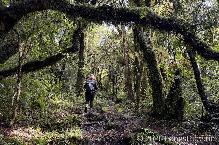
This was the slowest part of the day, maybe about 25 minutes for three quarters of a kilometer. The water and mud (and trying not to get our feet wet) slowed us down a little, but it wasn’t especially difficult. Just a little slow, as we bounced up and down, crossing several small valleys on the side of the mountain.
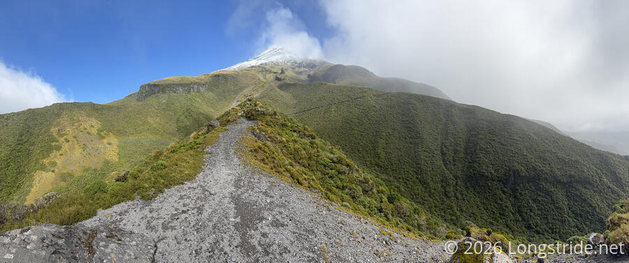
As we reached a deep crevasse on the mountain, the Ram Track turned north, downhill. The Veronica Loop Track (and therefore, us) turned south, following a ridge straight up the mountain. Shortly after the junction, a small gap in the trees gave a view towards the summit, still shrouded in clouds.
While somewhat steep, this was not a difficult section; its difficulty is largely a matter of how quickly you want to climb. Stairs made the steeper parts of the track easier to follow. There was less standing water, a combination of being close to the edge of the hillside and there being gradually less mountain above for the water to accumulate from.
We continued to be well-sheltered from the wind, though as we climbed, the trees got gradually shorter. The next kilometer gained us about 150 meters of elevation, taking us to the edge of the ridge line. A sharp turn east took us to another ridge and a junction with the Holly Hut Track.
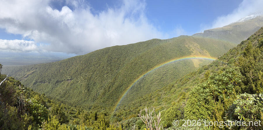
Turning south, we followed the Holly Hut Track further up the mountain, in search of a good view. It didn’t take long to find one: one of the most spectacular double-rainbows I’ve ever seen brightly beamed in a crevasse, with a view out to the farmland plains beyond the national park.
A little further on brought us to a clearing, offering another great view out to the farms surrounding the mountain. A sign warned against proceeding further in adverse conditions unless properly equipped and with an experienced guide. Our map showed another viewpoint only 150 meters ahead, so we decided it would be safe enough to go that far.
It was a quick walk to the viewpoint, an exposed area where the trail rose above the tree line and settled on the top of the ridge. Upon arriving, we were quickly blasted with wind, no longer having trees or the side of the ridge to serve as a windbreaker. But it was well worth it. We got a better view of the valley with the rainbow, seeing also a cloud over the valley mimicking its arc shape.

Straight ahead was Taranaki’s summit. The Holly Hut Track continues up towards the summit, though turns off to the right at a trail junction further ahead.
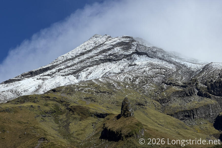
When we first arrived, clouds still hovered around the summit, often blocking it. After a few minutes, though, the clouds briefly parted, and we got a good view of the top of the mountain.
The summit area was covered in a fresh coat of snow. I was glad the wind had already convinced us it’d be a bad idea to attempt to go to the summit, and leaving the cover of the forest for the exposed ridge quite cleanly made this an obvious place to turn back.
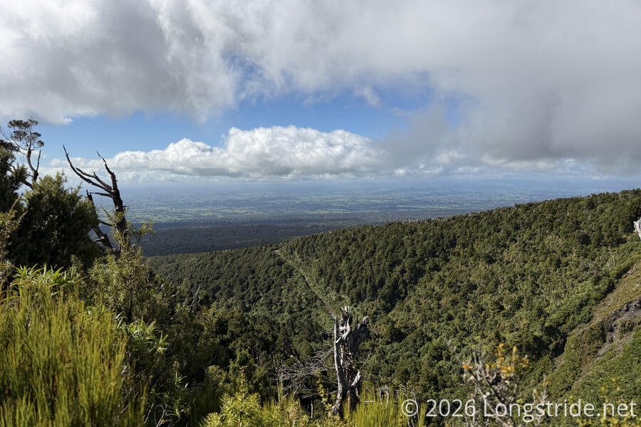
We returned down the Holly Hut Track, quickly re-joining the Veronica Loop Track, taking it back down the mountain to the visitor center. This side of the loop was more of a straight shot, and was a much more manicured trail. On the way up, we only passed a couple of people (on their way down); on our descent, we easily passed a dozen people heading up, if not more. Before dipping back down into the thick forest, we got one last look at the farmland in the distance. The park’s boundary is mostly defined by a circle six miles in radius from the summit, with farmland coming right up to the boundary.
Near the visitor center, we turned off the Veronica Loop to join a nature trail, a nice, easy loop.
The loop ended near the new under-construction visitor center; saws and drills pierced the tranquility of the forest.
A short walk back up the road and through a forest track, we returned to the temporary visitor center. The clouds again retreated from the summit, and we ate lunch at a picnic table in sight of one of New Zealand’s best views.
One day, we hope to be back to actually summit the mountain. Until that day, we’ll have the memory of this hike, and something epic to look forward to.