The GR 131, in the Canary Islands, was my first long-distance hike outside of the United States. This trail was one of the most unique hikes I’ve done. Spanning a volcanic archipelago, we visited eight islands, all of them different in their own way, with their own unique character, not just in landscape and scenery, but also in civilization. And without ever having been there before, it’s hard to truly anticipate that experience.
Lanzarote
Lanzarote, the northeastern-most of the main islands, was my introduction to hiking on a volcanic archipelago, starting off on a dry desert trail not terribly unlike a mashup of the southern California desert and the volcanic landscape of Oregon. But being able to see the ocean while on a hike was new, as was the idea of walking from one end of an island to the other. (And then repeating the feat half a dozen times on different islands.)
A wilderness trail, the GR 131 is not. Most of the trail on Lanzarote was on road, perhaps roughly split two-thirds dirt road and one-third paved road. This was the case on most of the other islands. And while each island did have stretches that resembled what I would consider to be a “hiking trail”, far more often than not, the track was along road of some kind. (Usually dirt, sometimes paved.) Fortunately, there’s not much traffic on most of those roads, but it’s really rather hard to fully escape signs of civilization on the GR 131.
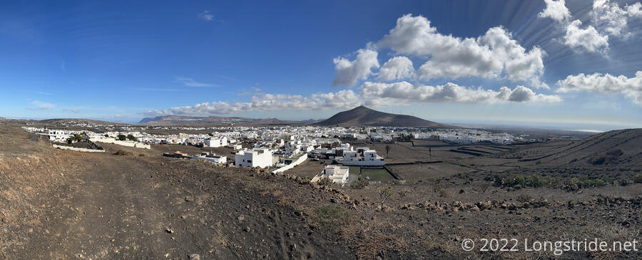
If there’s one thing that stood out in my mind about Lanzarote, it’s a persistent architectural sameness that renders the whole island bland. Nearly every building is cut from the same school of design: flat and boxy, with white walls and green window and door trim. This is partly due to the influence of local artist César Manrique, and as a result, homeowners are encouraged to preserve the traditional style and maintain visual unity. While this has certainly kept the garishness of high-rises (especially in the touristy areas of the island) to a minimum, to me this makes the islands towns all visually boring, and outside of the cities, there was little to distinguish one town from another. This minimalism is unique to Lanzarote, and the other islands all had more varied architecture, especially in the larger cities on Gran Canaria and Tenerife.
Several times, we were able to see the ocean on two sides of the island at once, which was something new for me.
We crossed the island in three days, based out of its capitol, Arrecife, so every day began and ended with a walk to and from the bus station, and a bus ride on the intercity bus service out to distant parts of the island. We were a little surprised at how well managed the bus service seemed to be, and also how inexpensive it was to get around. (Taxis would have cost us an arm and a leg.)
Weather on Lanzarote was nearly perfect hiking weather, except for a small bit of fog near the summit of Peñas del Chache. We were there just after a calima — Sahara sand blown into the air — had finished blowing through, so it was still occasionally hazy in the distance.
Fuerteventura
Before tackling Fuerteventura, we made a short detour to Isla de Lobos, just offshore. The entire island is a wilderness preserve, featuring a saltwater marsh that attracts numerous species of migratory birds. With the automation of the island’s lighthouse, there are no permanent residents, and access to the island is limited to the hiking trails and a beach. A fairly small island, Lobos made for an excellent day-hike.
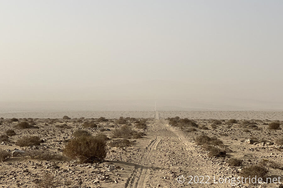
Fuerteventura is the most desert-like of the Canary Islands, featuring an actual sand-and-dunes desert in the south. We hiked across the island in seven days; the first two based out of Corralejo, the last two from Morro Jable.
The weather started out great, but by the second day, another calima started to blow through, making things much more hazy. We wound up several days hiking while wearing our coronavirus facemasks because the air quality was so bad. From a health perspective, we probably shouldn’t have been outside at all, let alone hiking, but we still had a much better time than we would have had just sitting around in a hotel room waiting for better weather. (The calima also didn’t stop several runners we saw.) Still, this made Fuerteventura my least favorite island. Its scenery was often obscured by the sand in the air, and hiking through sand dunes under those cases was both mentally and physically arduous. We’re looking forward to coming back some day to hike the island at a time when we can actually see the views.
Compared to Lanzarote, the trail felt a bit more remote when it wasn’t in or near towns. When in town, we were happy to see a bit more diversity of architecture. We also appreciated that each town had a large sign with its name on it, each being a unique design on a common theme.
We saw a fair number of other hikers on Lanzarote and Fuerteventura, but past there, with one exception on Gran Canaria, about the only people we saw on the trail were local runners or mountain bikers.
Gran Canaria
We spent five days on Gran Canaria, bookending three days of hiking with visiting with a friend of mine and his wife in Las Palmas de Gran Canaria. The weather on Gran Canaria was much better, with the calima having mostly (but not entirely) dissipated.
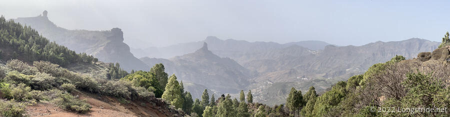
Gran Canaria was unique in that the GR 131 has not actually been developed on the island. Instead, we followed a route described by our guidebook as a likely eventual routing of the trail. This unfortunately started with a very long asphalt roadwalk for almost the entirety of our first day hiking the island. We did get great views, though, as the “trail” gradually climbed up a ridge between deep valleys. Our second and third days on the island had no shortage of incredibly stunning views (only slightly marred by some sand in the air), and we finished our hike coming down a trail so steep and rugged that even the Appalachian Trail’s White Mountains would have been proud.
Gran Canaria also gave us our first hiking in forests, albeit thin, on the Canaries, starting off desert-like and gradually becoming greener as we traveled north and gained in altitude.
In the towns of Ayagaures and Tunte, we tried a local delicacy, papas arrugadas (wrinkled potatoes) with mojo sauce. They were the best potatoes we’ve ever had. (We had the dish at a couple of other places, but it was best on Gran Canaria.)
The large towns in Lanzarote (Arrecife) and Fuerteventura (Corralejo and Morro Jable) felt more like large tourist towns than cities. Gran Canaria gave us our first “proper” city on the islands, Las Palmas de Gran Canaria, which has a larger population by itself than all of Lanzarote and Fuerteventura combined. While it was great to meet my friend there, the hustle and bustle of city life was quite intense compared to the much more relaxed environment we’d been in.
Tenerife
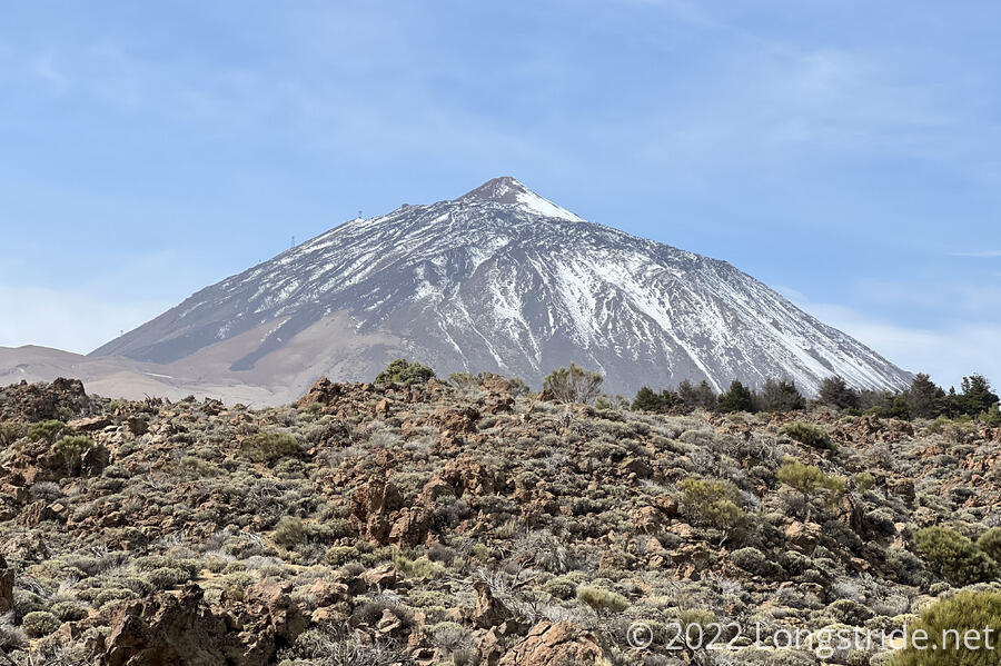
Tenerife, home of El Teide, the highest mountain (and volcano) in Spain, was our next stop. Tenerife is the only of the islands where the GR 131 does not stretch from coast-to-coast. Instead, it starts and ends a fair distance inland (and above sea level). We spent a day traveling to the island, and then hiked through in four days, starting in La Esparanza, stopping in La Orotava, and then spent the next two nights based in Vilaflor.
Tenerife was immediately recognizable as being much more forested than the prior islands, a welcome change of scenery, even if that forest only lasted for our first two days. We’d hoped to be able to summit Teide, however there was still quite a bit of snow on the mountain. (It was early February; we’ll have to come back some time in the future when there’s better weather.) Instead, we hiked along the inner edge of the caldera surrounding Teide, which may have been one of our easiest days of hiking, even if it was also one of our longest.
The trail on Tenerife was the first time to me the GR 131 really felt like a wilderness trail at length, at least in parts, only passing through a handful of towns. It was also one of the most difficult to plan, because of a shortage of available accommodations in town and the complete prohibition on camping within the national park surrounding Teide.
La Gomera
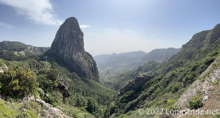
Our next island was La Gomera. The second-shortest of the islands, just over 28 miles. It took us two days to cross the island, and we felt that if we’d been in full hiking shape, started earlier in the day, and had more sunlight, we probably could have hiked the whole island in one day. Not that we’d want to, because that would have given us less time to take in the scenery. La Gomera’s scenery was spectacular, and this was my favorite island, perhaps tied with Gran Canaria for that title.
La Gomera has forests, though we didn’t spend much time in them. Instead, the trail largely followed the ridge from the ocean to the island’s summit, roughly centrally located, and then a somewhat more circuitous path down the mountain to an extremely rough and rocky beach in the north.
Part of the forest on La Gomera is usually a “cloud forest”, being perpetually in the clouds during the wetter parts of the year. For us, though, it was nice and dry, and the clouds remained above us.
The central portion of La Gomera featured numerous deep (and lush green) valleys, with several large rock formations standing hundreds of feet higher than everything else nearby, standing firm against the slow and steady force of erosion whittling away at the rest of the island.
La Palma
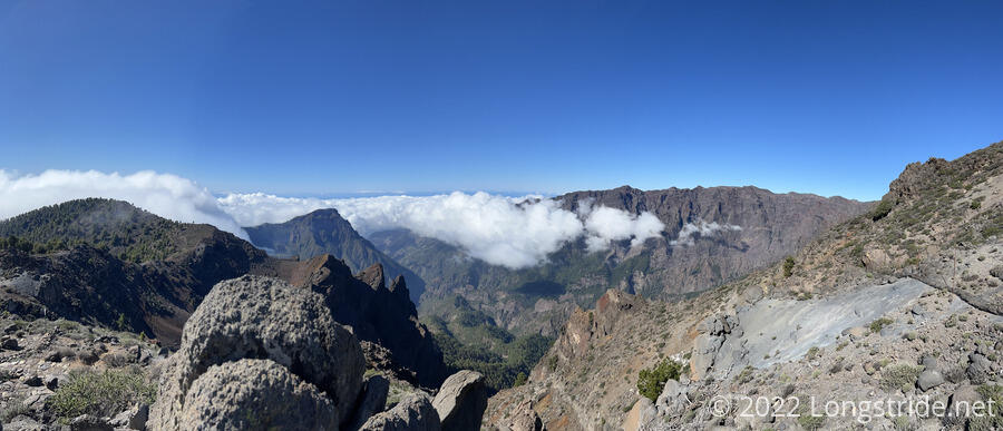
La Palma was our most disappointing island, though that was as much our fault as the island’s. Late in 2021, a volcano on La Palma erupted. After it was declared dormant in December, we’d assumed that meant we would not have any issues hiking the GR 131 on the island. Unfortunately, we were incorrect in that assumption, as a fairly long stretch of trail was closed for safety reasons. This forced us to skip a large chunk of the trail along the Ruta de los Volcanes, which after our first day of hiking on the island, we were very much looking forward to, as it would have been a unique landscape, the most obviously volcanic and desolate stretch of the Canary Islands.
Due to time constraints, we only budgeted three days for La Palma. If the trail hadn’t had a section closed, we probably could have hiked the whole island in that time. But the closure forced us to spend a lot more time traveling between towns than we’d anticipated, cutting significantly into our second day of hiking. Further, we had essentially the worst weather we had the entire time we were in the Canaries while we were on La Palma, and high winds and icy conditions forced us to abandon a very long third day of hiking the GR 131 in favor of a roadwalk and different trails so we could avoid dangerous trail conditions.
We did, however, see just enough of the island to know that we have to come back to La Palma and hike the parts that we missed. The Roque de los Muchachos area was spectacular, and we’re looking forward to seeing it again.
El Hierro
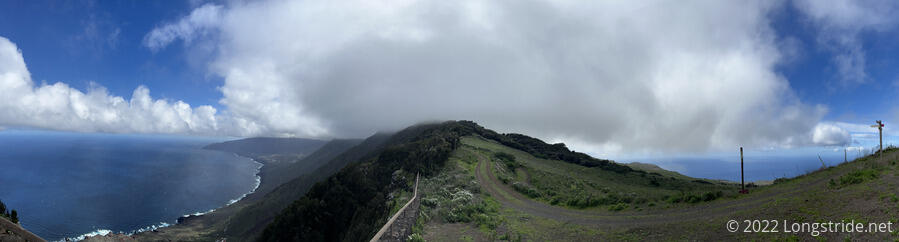
El Hierro, the westernmost and smallest of the Canary Islands, was an easy, though scenic, capstone to the hike. Our first day of the island climbed from the ocean to the town of Valverde, and then followed an almost 300 year old pilgrimage trail roughly down the center of the island. We gradually gained in elevation, passed through a very small town, and followed a road through fields, separated by low stone walls. With volcanic calderas nearby amid lush green rolling hills, this portion of El Hierro was one of the most unique landscapes we visited.
Our second day on the island, and our last day of hiking, continued us to and over El Hierro’s high point, Malpaso, down to the sanctuary where the pilgrimage trail starts, and then brought us to the ocean at a very remote beach. We detoured to a monument dedicated to the Meridian of El Hierro, once the westernmost known lands to Europe.
As with La Palma, we wound up in the clouds for a substantial portion of the trail around Malpaso, which was disappointing, but the rest of El Hierro more than made up for that.
A Stunning Volcanic Archipelago
The one thing each of the Canary Islands have in common is that they are all volcanic. The entire island chain is the result of relatively recent (and ongoing) volcanism, and evidence of that is visible almost everywhere you go. Beyond that, the varied and distinct microclimates provide a diversity of unique scenery that few other places can match.
Despite some hardships (which I’ll write more about soon), we had a great time exploring the islands, and we’re looking forward to revisiting them in the future.