We continued along the south coast of the Yorke Peninsula, with some rough trail and nice beach along the way.
After a hot day yesterday, we were elated that it was cool this morning.
With even further to go than yesterday — over 32 km — we didn’t feel like we had a lot of time to waste. Remembering how the trail near the campground was somewhat iffy yesterday evening, we opted to just go back to the road and continue from there. (The hiking trail was eventually going to rejoin the cyclist trail on the road anyway further ahead.)
Fortunately, the road continued to be quiet, though a couple of big trucks drove through, kicking copious amounts of dust into the air.
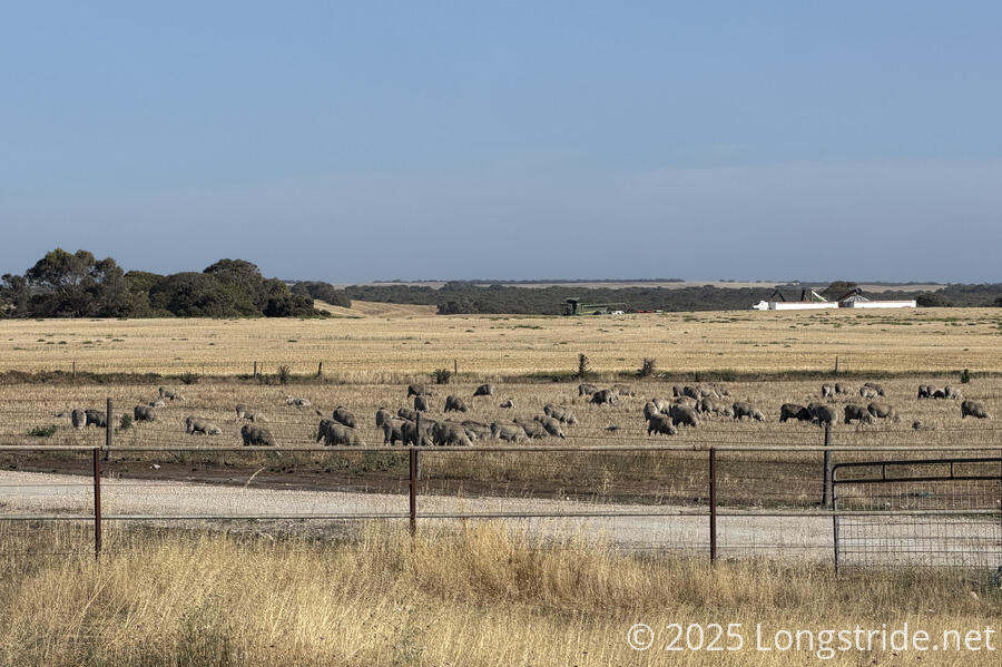
We also passed by another of the very few sheep farms we’ve seen on the trail.
On the road, we saw two dead parrots, probably killed by the trucks that zoomed past us. In the trees at a road intersection, a small flock was screeching loudly. A bit later, on a smaller road, we saw a kangaroo and its joey hopping away.
The “end” of the road split and went behind two locked gates with “private property” signs on them. A trail sign requested hikers stay in the foliage between the two property lines. This would have been an eminently reasonable request, if the trail could have gone more than twenty meters before turning into an overgrown bushwalk through dense trees and bushes. We followed the trail as best we could until deciding it was too much of a mess to walk through, and bailed out to one of the roads. Reasoning that as long as we stayed firmly on the roads and between the two fences on either side, we were fine, we stuck to the road and hurried along as quickly as we could; the sooner we weren’t in a questionable place the better.
Eventually, we crossed through a gate, and a short while later, entered the Port Davenport Conservation Park. First on road, and then trail, we followed the path, eventually arriving at Sturt Bay.
We got to the beach on Sturt Bay about two hours before low tide. It was fine to walk on; there was usually (but not always) sufficient hard sand for us. The beach wasn’t always very wide, though, and sometimes there wasn’t hard sand near the waterline.
This was a very long, and gently curving, beach. This made it feel a bit like an optical illusion. In the distance, the beach seemed to curve away sharply. But no matter how far we walked, the curve remained there, and it never felt like we were turning with the beach, even though it was clear that’s what we were doing on the map.
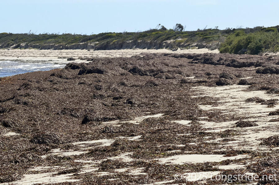
Just before we got to the Sturt Bay Shelter, we passed a section of water that had a lot of seaweed in it. It looked rather gross. It’s one of the very few places we’d walked past so far that had obvious seaweed growing so close to the beach.
We reached Sturt Bay Shelter around 2 pm, and took a very long break in its shade. With “only” another 10 km to go to Mozzie Flat, we decided there was plenty of time to make it there today (provided the beach continued to be as hikable as it had been). We hadn’t really considered this before, but, making it to Mozzie Flat also puts us in position to push a long 35 km tomorrow to reach Edithburgh a day ahead of our plan, and zero there. Which we’d definitely need after hiking 96 km in three days, on top of the four days from Point Turton to Marion Bay.
Leaving the shelter, we immediately hit an incredible amount of seaweed on the beach, some drifts easily half a meter or more tall. It was a bit of a slog to get through the couple hundred meters of the thick seaweed, but once we did, we had a very easy beach walk the entire rest of the way to Mozzie Flat.
We also passed the Marina Banggara fence, a porous predator-control fence that stretches across the peninsula, from Flaherty Beach (which we crossed just before reaching Point Turton) Sturt Bay. The fence protects the tip of the peninsula, which contains its largest swath of native vegetation (including Dhilba Guuranda - Innes National Park, and other conservation areas and private lands not used for farming). In this area, the plan is to reintroduce native animals which have become locally extinct, in an attempt to restore more natural ecological function.
To get off the beach and up to the Mozzie Flat Campground, we climbed a quite tall staircase, which had been boarded up on the top, requiring us to climb over to get into the campground. (Fortunately, this was possible; it didn’t seem like there was any other way up to the top of the cliffs from the beach.)
A sign at the shelter said that the name of the location was of uncertain origin (and almost certainly not derived from mosquitoes, which the site doesn’t have in any particular abundance), but possibly referred to the “Mosquito Fleet”, a fleet of ketches that transported goods from Adelaide to burgeoning towns on the Yorke Peninsula.
After getting our tent up and dinner cooked (which was a little challenging in the wind), we debated what to do tomorrow. While we have the option to only hike 25 km to a campsite tomorrow and then a short 10 km day to town, the long day tomorrow to give us a day off seems like the better option.