Our last, and second longest, day on Walk the Yorke brought us to its terminus in Port Wakefield.
With a long (33.3 km) day planned to get to Port Wakefield, CareFree and I … didn’t leave particularly early like we wanted to. The caravan park office didn’t open until 8:30, so we couldn’t leave before then anyway. And the general store didn’t open until 9, and I wanted to get some soda to supplement my water.
The general store was only a short walk from the caravan park. Once there, we got soda, and ice cream, because why not? (Alas, no coffee for CareFree, their coffee machine wasn’t working.) We also talked with the owners for a little while. They were impressed we were doing Walk the Yorke, and said we would definitely enjoy the scenery on our next trail: the coast-to-coast Tasmanian Trail, across the center of the island of Tasmania. They sent us off with a Port Clinton post card and sticker pack.
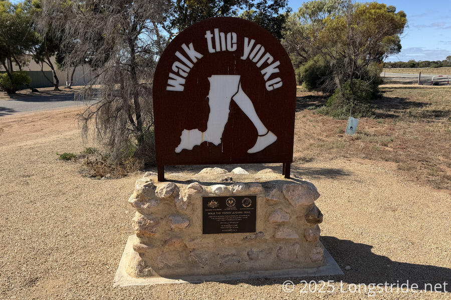
On our way out of town, we passed a dedication plaque and monument to the completion of the Walk the Yorke. It seemed a little funny placing it here, rather than at one of the termini, and it was certainly nicer looking as a monument than the large signs at the start and end of each section.
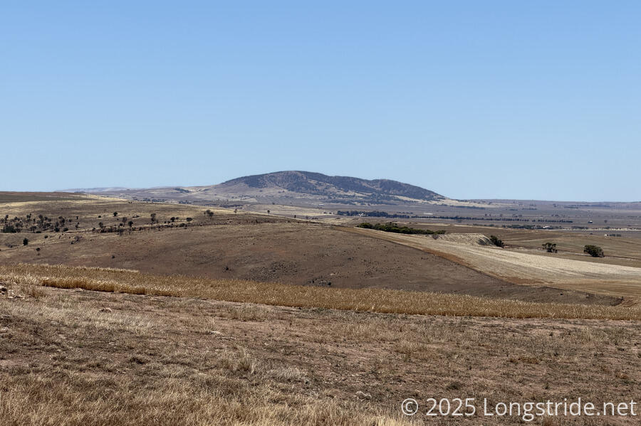
We followed a long, mostly straight dirt road northwest from Port Clinton. Rather than following the coast, the trail here diverted inland, gradually climbing up the foothills south of the Hummocks. At a whopping 147 meter elevation, this was the highest elevation by nearly a factor of 3. The trail breached 50 meters once before, near Daly Head, and came close on a couple of other occasions, but most of the time, was below 25 meters. (Of course, we spent a substantial amount of time at, or even below, (mean) sea level when walking on the beaches at low tide.
After about an hour, and some light switchbacks near the top of a ridge, we turned north, following the ridge for another two hours (including a break). Our break was a bit ill-timed; if we’d gone another five minutes, we could have sat down on an almost-shaded bench, rather than on the side of the road.
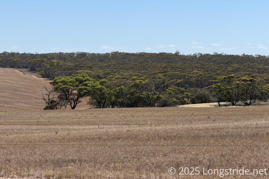
Of course, the road up, across, and down the ridge was flanked by farms, and didn’t escape the breeze blowing in off the water. A couple of dust devils formed over one of the farms.
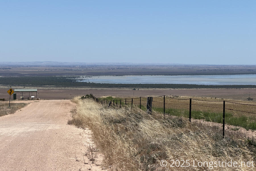
We did have some nice views of Gulf St Vincent, as well as the Clinton Conservation Park, which the trail would skirt for much of the afternoon.
Along much of the ridge traverse and descent, South Hummock was visible, poking up above the distant ridge. It was easily the highest land visible along the entire trail.
Thanks to some pine trees along the road, the construction of some of the farmhouses near the road, and also the general dryness of the area, I got some vibes of the Pacific Crest Trail in Southern California. It wasn’t much, just a faint feeling. I think it was mostly the smell of the pines that brought it on.
After descending from the ridge, we turned southeast, heading towards the (formerly bustling, but now nonexistent) town of Port Arthur. Along the dirt road, a woman driving past congratulated us on having (nearly) completed the Walk the Yorke, and suggested that when we get to Port Wakefield, we should check out the Rising Sun Hotel for dinner, since it has really good food. We made a note of the place for later.
She also said she thought it was a bit hot out to be hiking today. Certainly, it was warmer than we’d have liked, but today wasn’t the hottest day we’ve hiked (and it certainly wasn’t the hottest day we didn’t hike).
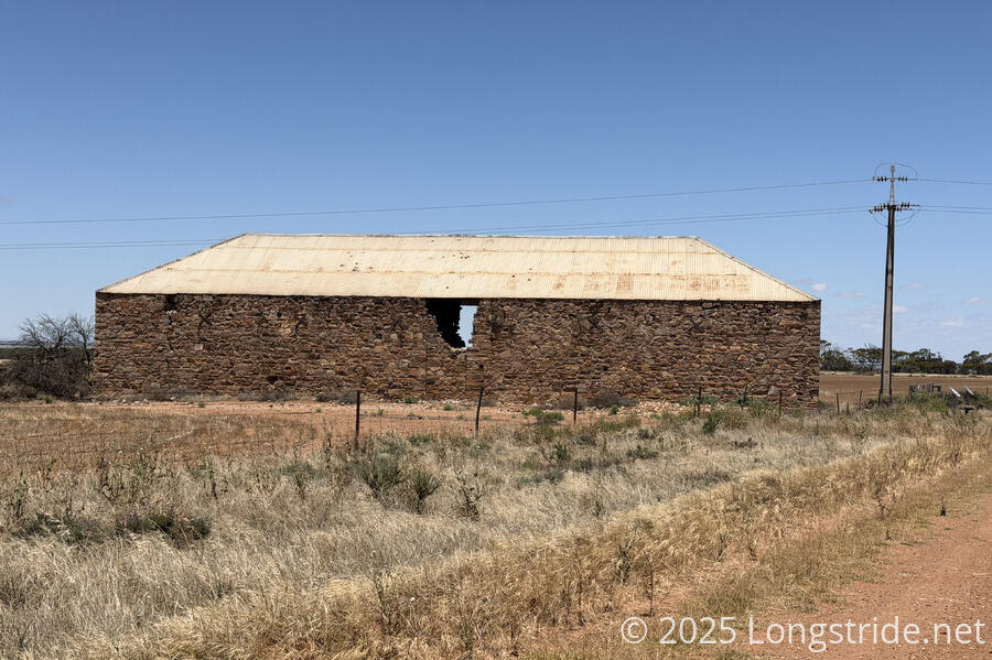
The road took us past a large stone structure with some large holes in it. A trail sign described it as the Yararoo Station Woolshed. Originally used to store wool from shorn sheep in the sheep station surrounding the shed, it later stored grain and hay, and then fell into disrepair in the 1970s after roof damage was caused by gunshots from pigeon removal(!).
The aboriginal storytelling plaque, which up until now had mostly lighthearted stories, told a vastly grimmer story:
“Once they got a hold of our old ancestors, they brought them back here. They put them up in the prison here. Removed the rock. Stuck the gun through and started shooting them. And that's now they dealt with the "Aboriginal problem" in those days.”
Yararoo Station Woolshed / Port Arthur Prison×Yararoo Station Woolshed / Port Arthur Prison
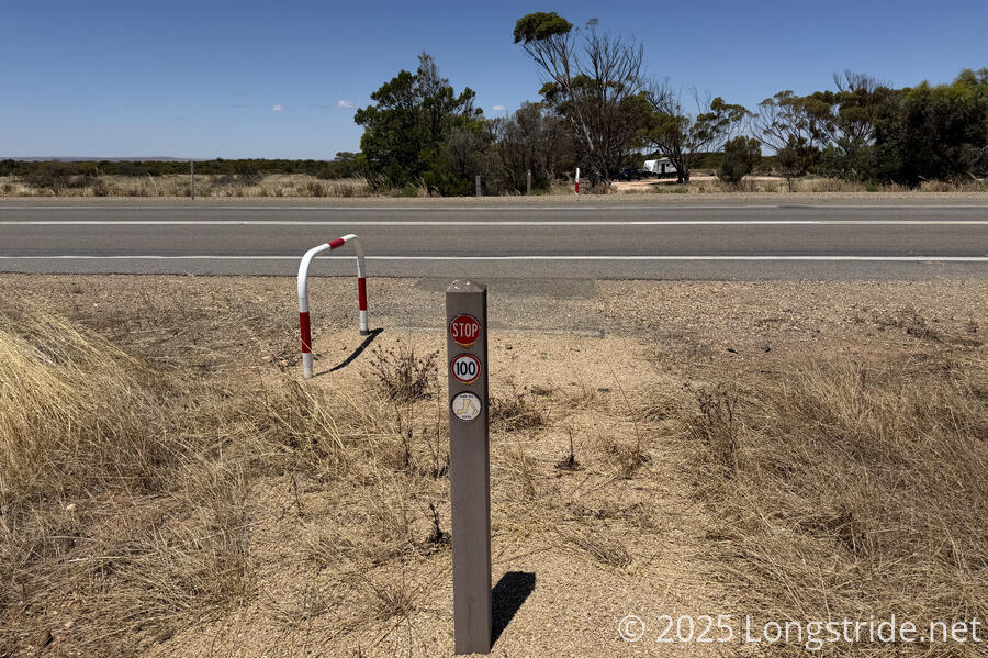
One of the things that Walk the Yorke does well is road crossings. Where the trail crosses a high-speed road, a special trail marker calls out the speed limit of the road, and red and white striped bike stand indicates that the trail doesn’t continue on that side of the road.
It’s not dramatic, but it’s more infrastructure than a lot of other trails have. (It also helps that Walk the Yorke doesn’t have that many high-speed road crossings.)
The trail entered the Clinton Conservation Park, meant to preserve the salt marsh at the head of the Gulf St Vincent, and mostly skirted around its boundary.
This was the roughest part of the trail today. Through the park, the trail was in a wide swath that had been cleared at one point for trail use. Now, it was a bit overgrown with grasses due to insufficient traffic, and our socks picked up plenty of seeds. Later, as the trail got pinched between the border of the park and the highway, some light scrub covered the ground completely in places, which made us a little nervous in light of yesterday’s sign about death adders.
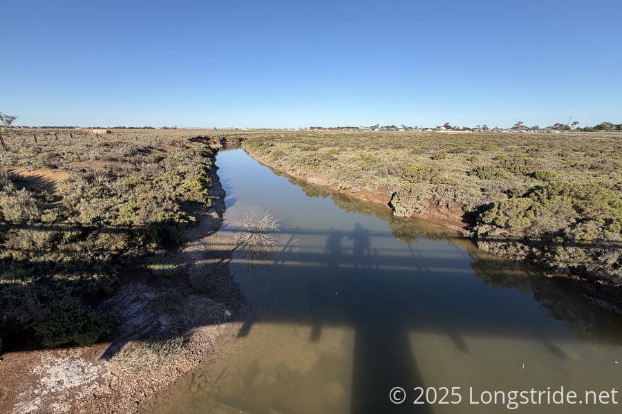
That tight stretch didn’t last long, though, and while the trail became somewhat indistinct for a short while, trail markers followed the fence line of the park, and there was a wide enough area between the road and the fence that there were many paths to choose from. This wide area came in handy when we reached a small, stagnant creek. There was no bridge, but we could walk around the creek by walking to the road and around the end of the creek where the creek seemed to just end.
While we were near the highway, several cars honked and waved at us as we went past. Given it seems like many locals are aware of the trail, we assumed they were giving us an early congratulations on completing it.
A pushed-over fence served a minor obstacle for the penultimate stretch of trail, a several-kilometer nearly-straight stretch along an old railbed.
This stretch a little reminded me of Wyoming’s Great Divide Basin on the Continental Divide Trail, only there was more green and zero cows. (While we’ve seen some cows on the farms we’ve walked past, it wasn’t very many. And thankfully, we never walked on farms, nor through open grazing land, so we’ve had zero encounters with large animals.)
A breeze that had dissipated when we descended from the top of the ridge began blowing again, as we were now more-or-less on a straight path towards the water.
This last bit of trail, I started to pick up the pace a little: the trail was almost over. I wasn’t really getting the “and I’m very ready to be done” feeling gotten on longer trails, like the CDT, Te Araroa, and the East Coast Trail. I think it’s because Walk the Yorke hasn’t been particularly challenging (apart from the near-constant sun exposure), and while I was glad to be nearly completed, I didn’t really have the exhaustion those three trails gave.
Entering into Port Wakefield, we crossed over the Wakefield River, on a brand-new footbridge that saved either a long detour, or getting our feet wet.
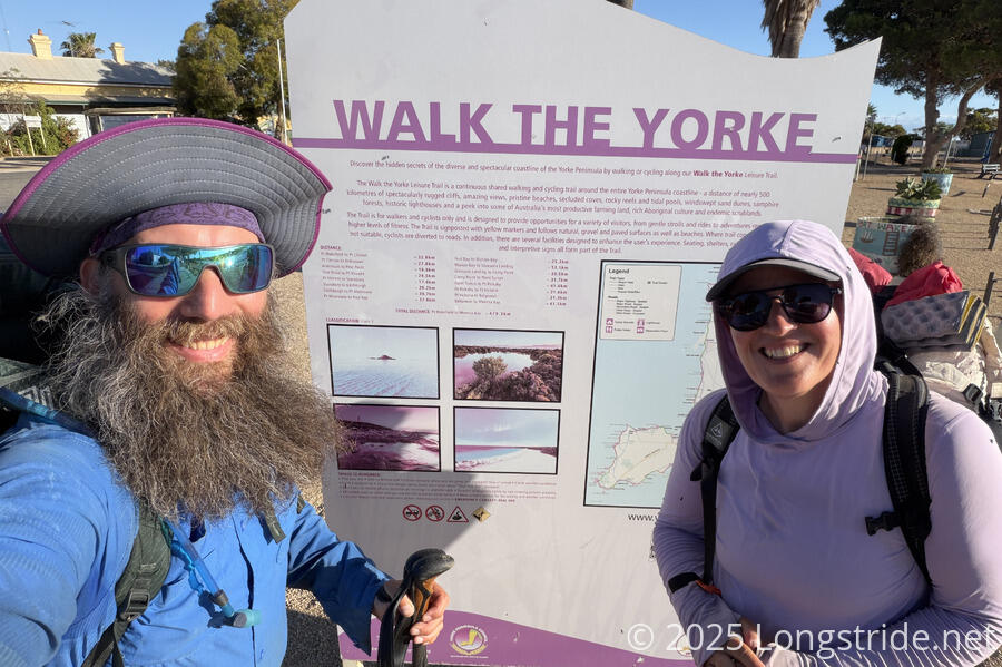
The terminus was a simple sign describing the trail overall on one side, and this section of trail on the other, just like the terminus at Moonta Bay. There was nothing grand about it, just the simple acknowledgment that we had walked the Yorke.
A couple minutes later, we were at the Rising Sun Hotel to get dinner (which was great), and then we made our way to the Port Wakefield Caravan Park, where a cabin awaited us.
Tomorrow, we’ll make our way back to Adelade, and then prepare for our next adventure: a hike across Tasmania.