Today, we rounded Corny Point, turning us south, and taking us past a wide assortment of beautiful beaches.
The parrots were up and squawking away at 5:30 am, an hour before we’d planned to get up. Surprisingly, their racket didn’t carry well through my sleeping bag, so I was able to go back to sleep, at least until my alarm went off.
CareFree and I were up and done with breakfast in the kitchen just in time; the kids from the surf group filled the kitchen with chaos and breakfast-making shortly after we were done.
One final chore remained before we left: booking a campsite at Shell Beach in Innes National Park for tomorrow night. It’s next to a lake, so we expect there to not be a problem with water.
Around 8:30, we continued west along the road in front of the campground, rather than backtrack to the beach for a continuation of yesterday’s lousy beach walk. This took us past the Corny Point General Store, which was unfortunately still closed as we walked past.
Some clouds blocked the sun, but with no wind, it was not especially cool.
The road brought us to a bench at a public BBQ area, and we stopped for a short early break to give our feet a little rest after walking along the road for an hour. A small box on one of the picnic tables had several painted rocks for a rock swap. We took one painted with a cat, and will drop it off somewhere else along the trail.
We continued to follow the road (with a farm on the inland side, as expected). After another half-hour, a trail marker suggested we were supposed to scale a fence and wade through waist-high grass. Not wanting to do either, we stuck to the road. (Not that we’re particularly focusing on any sort of trail purity here, but most of our road divergences so far have been along the Walk the Yorke cycle path, so we’re still “on-trail”, for some definition of on-trail.)
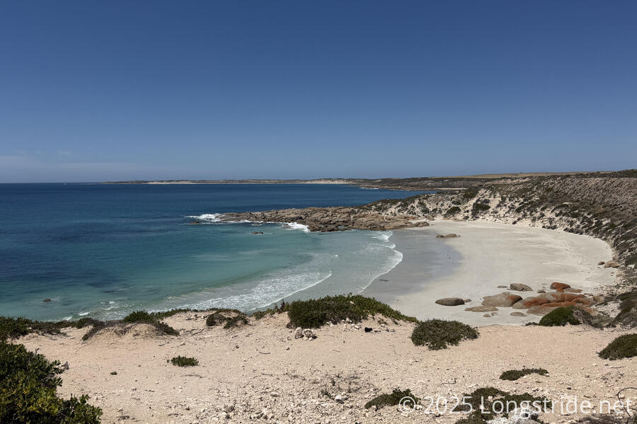
Nearing Corny Point, we eventually rejoined the trail, following the cliffs around the north prong of Corny Point, and then dropping down to a beautiful crescent-shaped beach.
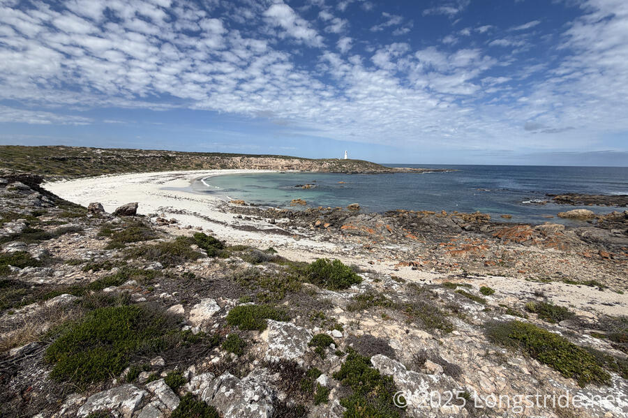
Dropping down to the beach, and then climbing back up on the other side to the Corny Point Lighthouse may have been the two steepest climbs we’ve had so far, the descent made more difficult by a lack of signs and unclarity in which sandy path to follow.
At the lighthouse, we took a break in the lighthouse’s shade, the breeze from the ocean almost making it too cold despite the otherwise bright sunlight. A woman who tented next to us at the caravan park arrived at the lighthouse about a half hour after we did, which was a little amusing for all three of us.
We had picked up no small number of flies walking near the farms earlier today. Despite the breeze at the lighthouse, they were still swarming around us, though fortunately in smaller numbers than when we arrived.
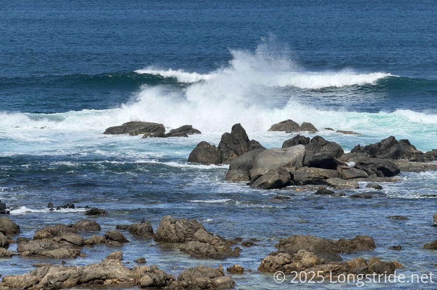
So far, the waters of the Spencer Gulf have been mostly sedate; gently lapping up on the shore or with nice orderly waves. Now that we’re again on the western coast of the Yorke Peninsula, and heading closer to the mouth of the Spencer Gulf, we started to see some waves crashing on the rocks, reminiscent of the much more vigorous ocean along the Great South West Walk and Great Ocean Walk that we were accustomed to along Australia’s southern coast.
The trail from the lighthouse lead us along a sandy path on the clifftop. It was fine for a short while, but then the trail kind of fizzled out and became overgrown. Not wanting to walk through overgrown bush (we’ve yet to see snakes, and we’d also prefer not to press our luck), we followed a path down to the road that paralleled the coast, again walking next to a dusty farm.
While we were on the road, a couple in a passing car stopped to ask us if we were good.
Fortunately, we were only on the road for about ten minutes, after which we reached the parking lot and toilet at the northern beach access for Berry Beach, and made our way to the beach.
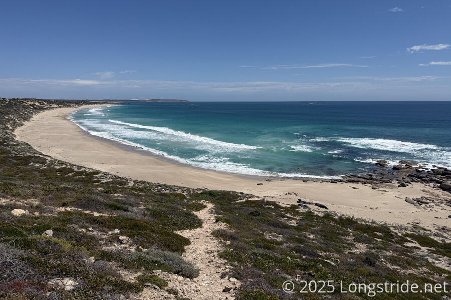
While we were still on the cliffs, we could see that Berry Beach should be nice to walk on: no seaweed, and a wide, gently-sloping beach. Off in the distance, we could see two groups of surfers, the group camp we saw at the caravan park last night.
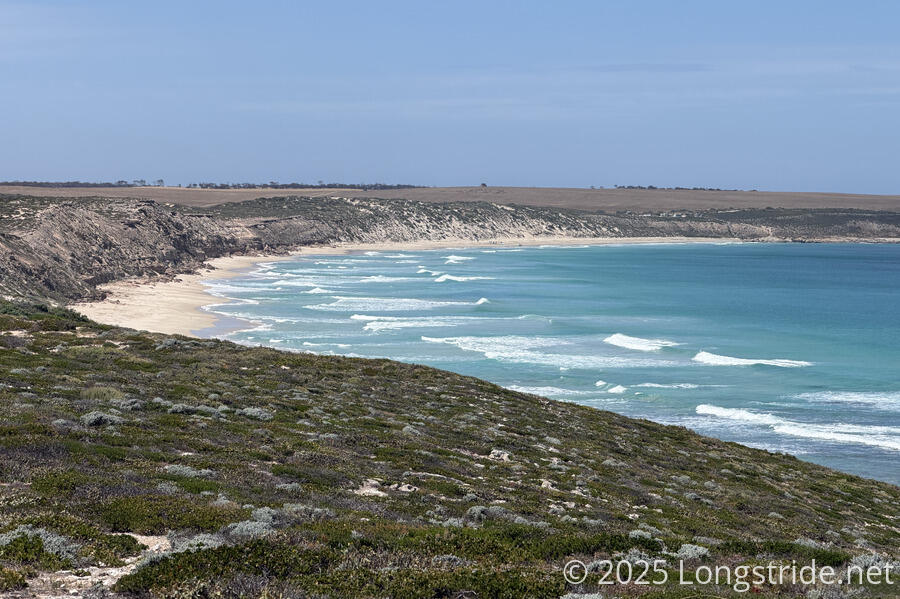
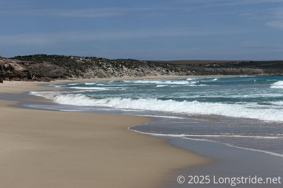
As expected, the beach was wonderful to walk on. What we didn’t fully appreciate from the clifftop was just how clear the water was. I imagine that during the peak of summer, this beach would be relatively packed with swimmers, surfers, and sunbathers alike.
The waves swept in with a strong regularity, seeming almost perfect for beginner surfboard lessons.
We had a brief chat with the instructor from the Port Vincent Aquatic Center we’d spoken to last night, who came out of the water to greet us as we came close.
Leaving Berry Beach, the trail scrambled up and down rocks and sandy trail, accessing several more small, beautiful, secluded beaches with extremely still water.
Eventually, the beaches ended and the trail climbed up onto the cliffs. Off in the distance, we could see a small pod of dolphins.
We took a break, exposed in the sun, at a nice overlook. The flies returned, becoming quite annoying. At least we had a nice view.
At Point Annie, the trail climbed down a steep dune to bring us back to the beach, which we followed to the Swincer Rocks campground. This beach wasn’t fun to walk on; it was somewhat sloped, making walking more difficult. With the rougher sea, the waves frequently splashed up onto the shore where we were walking frequently, often pushing us further up-beach into the softer sand.
Still mid-afternoon, the heat was making it uncomfortable to hike, so we decided to sit down in the shade of the campground’s privy. The privy’s water tank had some water, so we took the opportunity to take a very long break, wait out some of the afternoon sun and heat, and cook dinner, saving us time at our camp tonight (and also reducing the amount of food we’d have to carry, and water as well, since we weren’t certain there’d be water at our campsite).
We resumed hiking a bit after 6 pm, the sun noticeably lower in the sky, and the temperature much cooler. The next beach started off lousy, with loose, shifting sands and a steep slope, but eventually leveled out and became more firm.
We passed a truck which had gotten stuck on the beach, its two occupants trying to dig it out: it couldn’t have been good that one of the truck’s tires was in a large hole half its height.
After seven, we reached the campground at Gleesons Landing, a large sprawling campground with many car campers and caravans enjoying the scenery.
Upon leaving the beach and entering the campground, we were greeted by two large, unleashed dogs that followed and growled at us, despite its owner, on a chair in front of his RV with a beer in his hand, insisting “they’re friendly”.
We kept going several more minutes, to what seemed like the far end of the campground, found a nice isolated spot relatively near two privies and a row of trash cans, and pitched our tent on some very soft sand.
We’re now a little more concerned about water tomorrow: our campsite, which on the maps is close to a lake, might actually be close to some salt flats. But so far, we’ve had water whenever we needed it, so we’re not too worried about it.