Compared to most other long-distance trails, the Continental Divide Trail is very much a choose-your-own-adventure trail. With numerous alternate routes available, it is quite likely that many hikers have traced unique routes on their journal along the CDT.
On my CDT hike, I took 38 alternate routes, 605 miles in total, which collectively bypassed 1067.5 miles of official trail and reduced the length of the trail by 462.5 miles. Here, I’ll discuss some of the more interesting alternates I took.
Gila River
The Gila River alternate in southern New Mexico, starting just north of Silver City, is 106 miles long and bypasses 175 miles from the circuitous main CDT route. This was by far my favorite alternate along the CDT. I’d have taken it in any case, but for 2022, it was mandatory: the Black Fire, burning directly on the trail, and which became one of the largest forest fires in New Mexico history, closed the official trail through the Black Mountains.
The official CDT heads northeast through the Black Mountains, an especially dry and remote area, then turns west, before finally resuming its northward trek.
The Gila River Alternate instead maintains a straighter (but still somewhat curvy) route north. After departing the CDT, the alternate follow a dirt road for about half a day, then follows a trail that becomes a long steep climb through a burn area before reaching the Gila River.
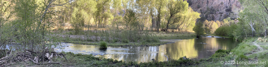
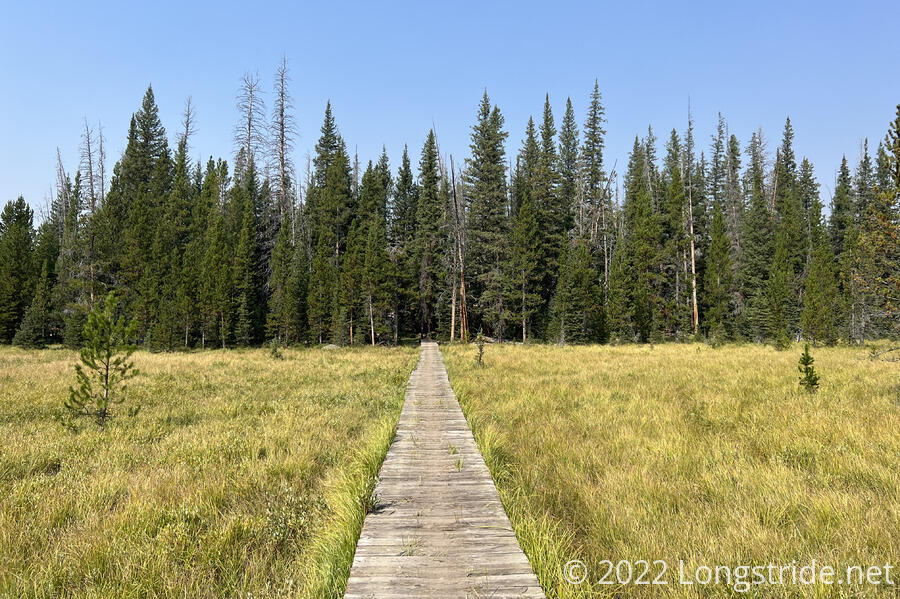
Once at the Gila River, the trail followed the river in the bottom of its canyon, for roughly 55 miles. There was no shortage of water.
When I hiked through in early May, the river was rarely more than knee-deep, but usually somewhat shallower than that. Featuring 250 (wet) crossings of the trail, this alternate couldn’t be more different than the official trail it bypasses. After a week in the desert before, this was a quite welcome change of pace.
This was the best part of New Mexico on my hike. It was great not having to worry about water for a few days, and the scenery was unlike any other in the state.
In in late season, this alternate can become impassable. Due to significant rains in October when I was completing the trail in northern New Mexico, the Gila River Alternate was impassable due to the depth of the river, adding a significant complication for southbounders.
Pie Town
The Pie Town alternate, about a day north of the end of the Gila River alternate, cuts off about eight miles from the official route, following a series of dirt roads all the way to Pie Town.
The primary reason to take this alternate is to avoid 12.5 miles of walking along a paved highway to reach Pie Town. Also, located along the alternate, about a day apart, are the Valle Tio Vences Campground, with a water cache, and the Davila Ranch CDT Rest Facility, which provides for “free” (donation requested) a place to stay with a roof, laundry, shower, wifi, gas stoves, and a refrigerator stocked with eggs, onions, potatoes, and cans of pork and beans. It certainly felt quite amazing to start off the next day hiking, from the middle of nowhere, showered and with clean clothes.
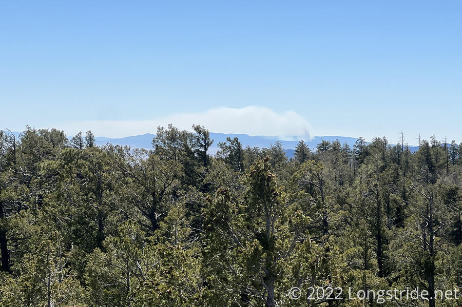
About a third of the way between the campground and Davila Ranch is Mangas Mountain, which has a fire tower. It was a little tricky to get up to the fire tower from the road, since the tower is normally accessed from a different road that doesn’t directly connect to the road the alternate follows. However, as is the norm for fire towers, there was a great view. (The tower was also staffed, and we were also able to see the nearby Bear Trap Fire.
Cebolla and Narrows Rim Trail
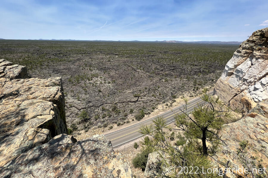
The Cebolla alternate, located about halfway between Pie Town and Grants, is about 25 miles long to bypass 35 miles of the CDT. The section of trail skipped goes through the El Malpais National Monument and the Chain of Craters Wilderness Study Area.
Before I started the CDT, I was looking forward to going through this area (though with reservations — I remembered the lava rock in Oregon doing a number on my boots). Once actually on the trail, though, I opted out largely because there was very little water, and the rest of my group preferred to take the shorter route.
The alternate started off along a dirt road, traveled along (or in) a dry gully, and an historic cabin, before joining another dirt road that lead to a paved road. Following the road would have made for a paved road walk of epic proportions, so to reduce the road walk a bit, I took the Narrows Rim Trail, climbing up onto a ridge overlooking El Malpais. This gave a fairly stunning view over the badlands, and went near the La Ventana arch. A rather involved rock scramble was required to climb off the ridge and rejoin the CDT at a parking area.
San Luis Peak
The detour to the summit of San Luis Peak traded about a mile of distance for an extra 1,400 feet of elevation gain, climbing up the first 14,000 ft mountain within easy reach of the CDT.
It had a great view, of course, though it was more important to me as being the first time I’d hiked above 14,000 feet.
Departing the CDT at a saddle, the trail largely follows the ridge line up to the summit, which was quite steep. It was quite windy when I was there, which helped make for a slow and steady climb up the mountain, and made it hard to stay for very long at the summit.
Descending the other side of the mountain, the trail was slightly less steep. Reaching another saddle, the trail turned down into a valley, paralleling the CDT on the opposite side of Organ Mountain. Some parts of the trail were a bit ill-defined, and the trail had been relocated from what was shown on my map, so navigation was a little bit confusing during the last bit of descent to the valley floor. After crossing Stewart Creek, the trail picked up again, following the creek downhill. After joining a dirt road for a short distance, the trail reached a trailhead with a pit toilet, and rejoined the CDT.
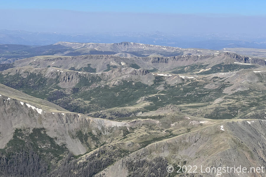
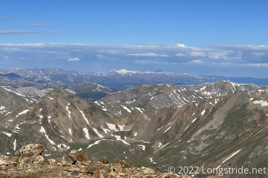
Mount Elbert
The highest mountain in Colorado, and the Rockies, Mount Elbert was number one on the list of mountains I needed to summit while on the CDT.
From just north of Twin Lakes, the South Elbert Trail turns off from the CDT, a somewhat steep, but otherwise gentle steady climb towards the summit. After about two miles, just below the treeline, we found a nice large campsite, which set us up for an early morning hike up to the summit. (The earlier we could summit and start heading back down, the better: earlier in the day, while still on the CDT, we saw storm clouds dropping snow on Elbert’s summit!)
Starting about half an hour before sunrise, I made the three mile hike to Elbert’s summit around in about two and a half hours. This was a slow pace, but between the steepness of the climb and the high elevation, it was not unreasonable.
The exhausting climb to the summit of Elbert was well worth it. From the top, there are great views of the surrounding mountains (in particular, Mount Massive, its neighbor and second-highest summit of the Rockies and Colorado). Also visible from the summit is the nearby city of Leadville, one of the highest cities in the US.
The hike down the North Elbert Trail is somewhat steeper, and it was rough going for about two miles until the trail dropped below the treeline, rejoining the CDT about a mile and a half later.
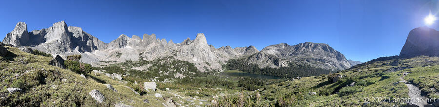
Cirque of the Towers
Without a doubt, Cirque of the Towers is the most scenic alternate off the CDT, and was my second favorite alternate of the trail.
21.5 miles long to bypass 22.4 miles of the CDT, but with substantially more elevation gain, the Cirque of the Towers alternate diverges from the CDT near the south end of the Wind River Range. As the CDT turns to the west to go along the western foothills of the Winds, the alternate heads straight up a glacial valley, crossing over Temple Pass and Jackass Pass to enter the cirque.
After crossing the cirque, surrounded by huge granite spires, the trail climbs very steeply up to Texas Pass, and then descends, even more steeply, down into another glacial valley. Once on the valley floor, the alternate gently follows a creek, until rejoining the CDT, once again in the foothills of the Winds.
The Cirque was the most physically demanding alternate I took on the CDT, but the views were well worth it. It’s one of those places where photographs can’t even begin to do justice to the view.
Butte Express
The Big Sky Cutoff (also known as the “Super Butte Cutoff”) is the CDT of alternate routes: there is no one route; rather, a general goal: turn the incredibly circuitous routing of the CDT between Yellowstone and Butte, MT into something resembling a straight line.
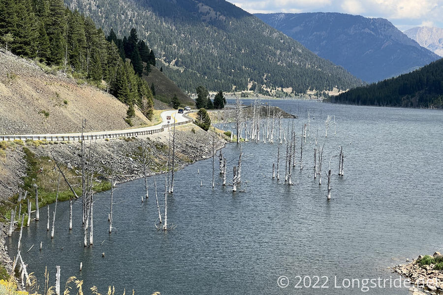
The earliest generally recognized departure is at Two Ocean Pass, where one can depart the CDT and head down the Atlantic Creek drainage into east Yellowstone. This, however, bypasses the Old Faithful area of Yellowstone, which I very much wanted to see, so instead I stuck with the CDT until shortly after West Yellowstone, MT, diverting onto an old alignment of the CDT. A network of trails and dirt roads, plus a bit of paved roadwalk took me past Earthquake Lake, some pretty amazing high plateaus and ridges, and a lot of ranches to reach the outskirts of Ennis, where I zeroed.
From Ennis, a longish paved and dirt road walk took me through the Tobacco Root Mountains, with abandoned mines and equipment sprinkled throughout. More road walk and a hitch on a school bus brought me to Whitehall. (I’d originally planned on hiking directly into town to avoid having to hitch, given there’d be a long road walk either way, but the oppressive heat — over 100°F — suggested adding a climb over a mountain pass was unnecessary.)
From Whitehall, another day on road, plus some forested trail returned me to the CDT northeast of Butte.
The whole alternate, 12 days in total, was roughly 178 miles long, bypassing 498.7 miles from the CDT. That is, near as I can tell, fairly close to the shortest route possible between West Yellowstone and Butte, while minimizing the length of CDT skipped and minimizing paved roadwalk. (A possibly slightly shorter route could have cut off earlier, taking dirt roads directly through West Yellowstone, but would also have reduced my time in Idaho to not even a full day, and included a very lengthy paved road walk out of West Yellowstone.)
I only took this alternate out of necessity: by the time I got to West Yellowstone, it was already near the end of August. The 321 miles this alternate saved saved me nearly two weeks of hiking; without it, I’d have arrived in Canada in the second week of October, to much colder weather and more difficulty getting away from Waterton Lake.
The large amount of road walk made parts of this alternate quite tiring, but largely it was still beautiful country, and while I’d have preferred being on the CDT proper, I don’t regret taking this route.
Other Alternates
A handful of other alternates warrant some mention.
Teller Montezuma: About a day south of Grays Peak, this alternate started off as a wrong turn, accidentally following a dirt road to the summit of Teller Mountain. Instead of backtracking, I took a very rough ATV road down the mountain into a valley, and then down the valley through the town of Montezuma. Past the town, the dirt road rejoined me to the CDT. Had I not made the wrong turn, I would likely have still done most of this unofficial alternate: dark clouds had been chasing me most of the day (eventually raining on me for most of the road walk), and the CDT follows a high, exposed ridge here. I likely would have made it to Webster Pass, opposite the valley from Teller Mountain, and then dropped down to the valley via a dirt road from the pass. This was the only time I had to take a detour to escape the weather.
Straight Creek / Ursus Fire Alternate: In Montana, at the southern end of the Bob Marshall Wilderness, this was the only alternate I took explicitly because of a fire closure. This alternate saved three miles (and almost a thousand feet of elevation gain) by following the Straight Creek down its valley, rather than climbing up a pass and going around the far side of mountain that formed the creek valley’s western border.
Spotted Bear Pass: In the Bob Marshall Wilderness, this 27.9 mile alternate to bypass 42.5 miles of CDT was purely about saving time. It cut more than half a day of hiking off an already long stretch of trail.
Ghost Ranch: In northern New Mexico, the Ghost Ranch Alternate, while about 2 miles shorter than the 27 miles of CDT it bypasses, is primarily about adding a resupply stop at Ghost Ranch to break up the otherwise long stretch between Cuba and Chama. While most of this alternate is along dirt roads, there are some incredible views of exposed sandstone cliffs that are otherwise not visible from the CDT, including a trek through a box canyon just north of Ghost Ranch.